Final report for FW22-401
Project Information
Past practices have contributed to economic growth at the expense of soil and water conservation, as indicated by degraded lands and creeks. There is opportunity to reverse land degradation and dehydration via sustainable shifts in agricultural land management. Climate change exacerbates the need for on-ground actions to occur at a time/ scale more rapidly than the current pace in order to optimize sustainable agriculture production.
This proposal demonstrates how integrated management shifts support land and water restoration and produce commercially viable crops. Current annual water use is ~5M gal- this regime is not sustainable, and needs to shift from water resource strain to agro-ecosystem production. The water regime needs to be well studied to provide the technical input required to design, and implement specific water management applications.
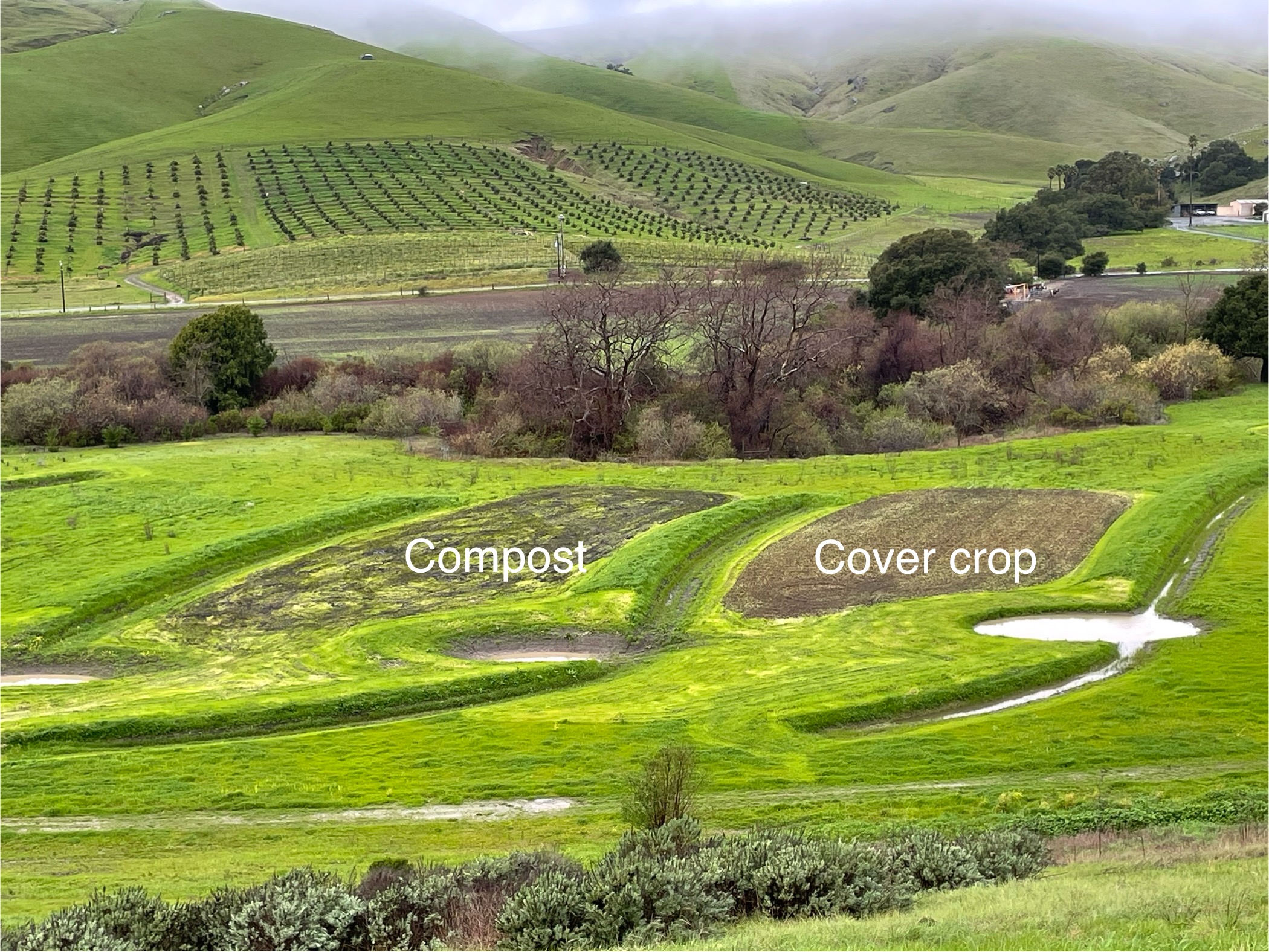
A basic understanding of the current water balance, opportunities for rehydration, and annual runoff (>700k gal) for 3 drainages have been approximated. Applying diverse solutions (conceptualized in the form of berms, swales, and recharge basins) can help infiltrate up to ~500k gal water per year. These treatments give an opportunity to measure and monitor rehydration efforts (see attachments).
This project has been shared across several environmental and agricultural based networks and posted on local community boards. Participants and visitors have included:
- Toro Creek Watershed Neighbors
- Upper Salinas Las Tablas Resource Conservation District staff (USLT RCD),
- City Farm San Luis Obispo Staff,
- Cal Poly Environmental Science Professors,
- Santa Cruz Permaculture,
- Creek Lands Conservation Staff,
- Local environmental freelance grant writers,
- San Luis Obispo (SLO) County farmers and ranchers,
- Local libraries: SLO and Morro Bay (MB)
- Local ecological environmental landscape architects
- Local hydrologists
- Local herbalist program
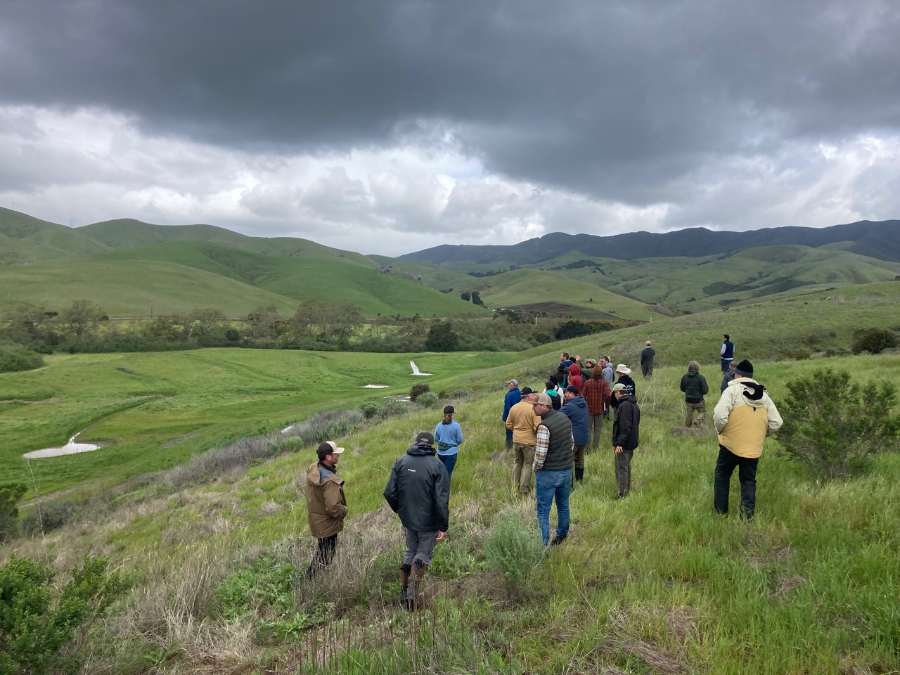
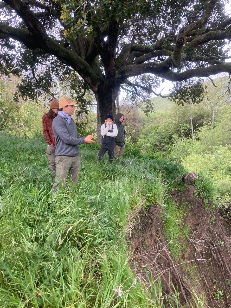
There were many tours and conversations held on the land with local interested parties. Additionally, Traceland held two workshops to share and educate the stakeholders developed over the grant period. One on rehydration and restoration, on April 5th, 2024 and a second on oak and acorn food on site November 11th 2023.
Feedback from the workshops were overwhelmingly positive and suggests growing awareness and interest in agro-ecological solutions that contribute to the resilience of watersheds and the food system as a whole.
Objective 1: Water management accounting (January 2023 - December 2023)
- An assessment of the consumptive water use of the Trace Farm to reduce the water footprint and off-set pumping from the agricultural riparian well that is hydrologically connected to stream flows in mainstem Toro Creek. Test the degree of hydraulic connection so that streamflow benefits can be quantified. Develop conceptual level concepts for water conservation, streamflow enhancement, and benefits to riparian floodplain habitat;
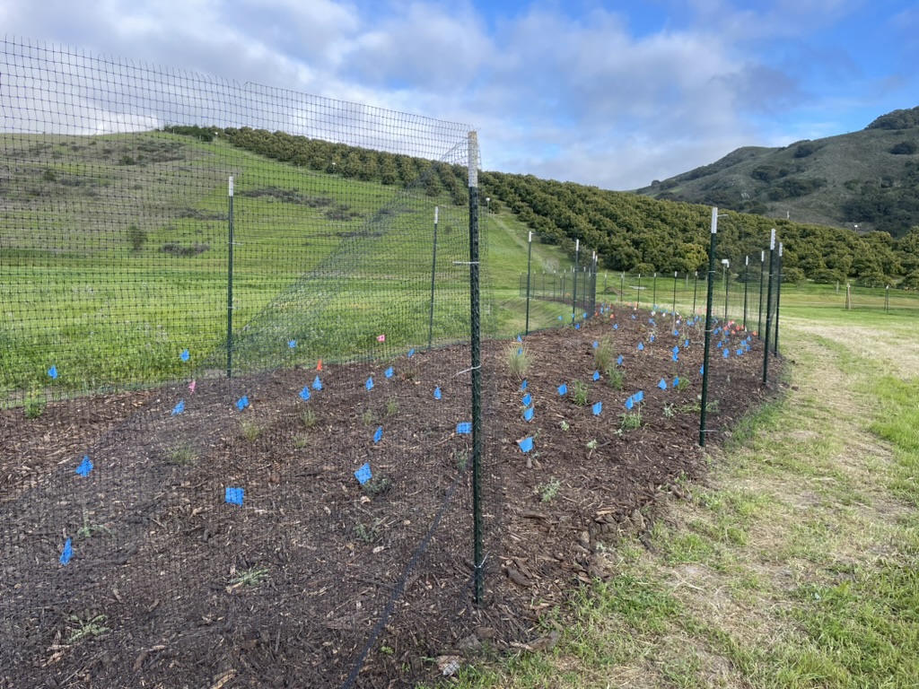
Objective 2: Expand agricultural operations onto valuable Class 1 alluvial soil and simultaneously restore native habitat across approximately 12.5 acres (Planning 2022, earthworks May and July 2023, Monitoring November 2023 – April 2024, Planting March 2024, Workshop April 2024, Planned remediation Summer 2024)
- We developed a master plan to establish native-dominant plant communities on a disconnected flood plain and adjacent hills to enhance botanical biodiversity and increase wildlife habitat complexity. The plan integrates productive agricultural ecosystems (e.g. edible landscape) that emphasize the diversity and functions of natural ecosystems as well as soil health elements such as mulch application, reintroduction of mycorrhizal mycelium, and evaluation of soil minerals.
- We held one workshop on rehydration and restoration agriculture April 2024
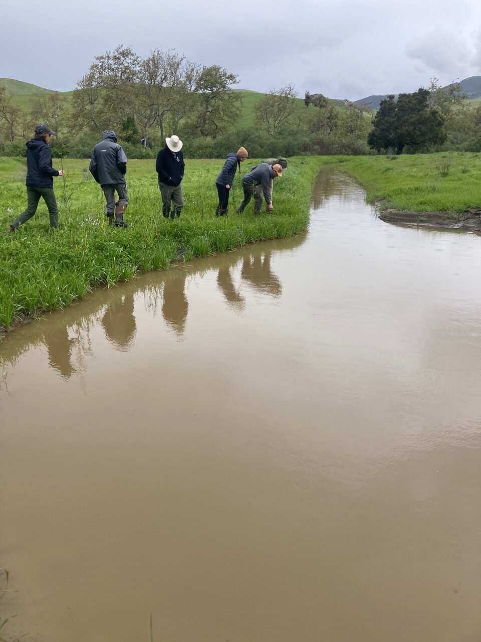
Objective 3: Reduce soil erosion and stream bank collapse 0.5 miles of Toro Creek (Planning 2022, earthworks May and July 2023, Monitoring November 2023 – April 2024, Planting March 2024, Workshop April 2024, Planned remediation Summer 2024)
- We assessed the drainage, and creek bank to determine where to divert stormwater and mitigate existing channel incision and erosion.
Objective 4: Capture > 500k gal stormwater run-off (similar timeline as Objective 2)
- We designed a rehydration system based on keyline farming principles using berms, swales, basins to capture runoff water.
- We held a keyline farming field day to assess the dynamics of water infiltration and its multiple benefits in relation to semi-arid mediterranean climates
Objective 5: Bio-sequester atmospheric CO2 (planting 73 trees)
- First we assessed the carbon emissions from the earthworks.
- Secondly we estimated the time required for native and foreign oaks to bio-sequester the CO2 emitted during excavation.
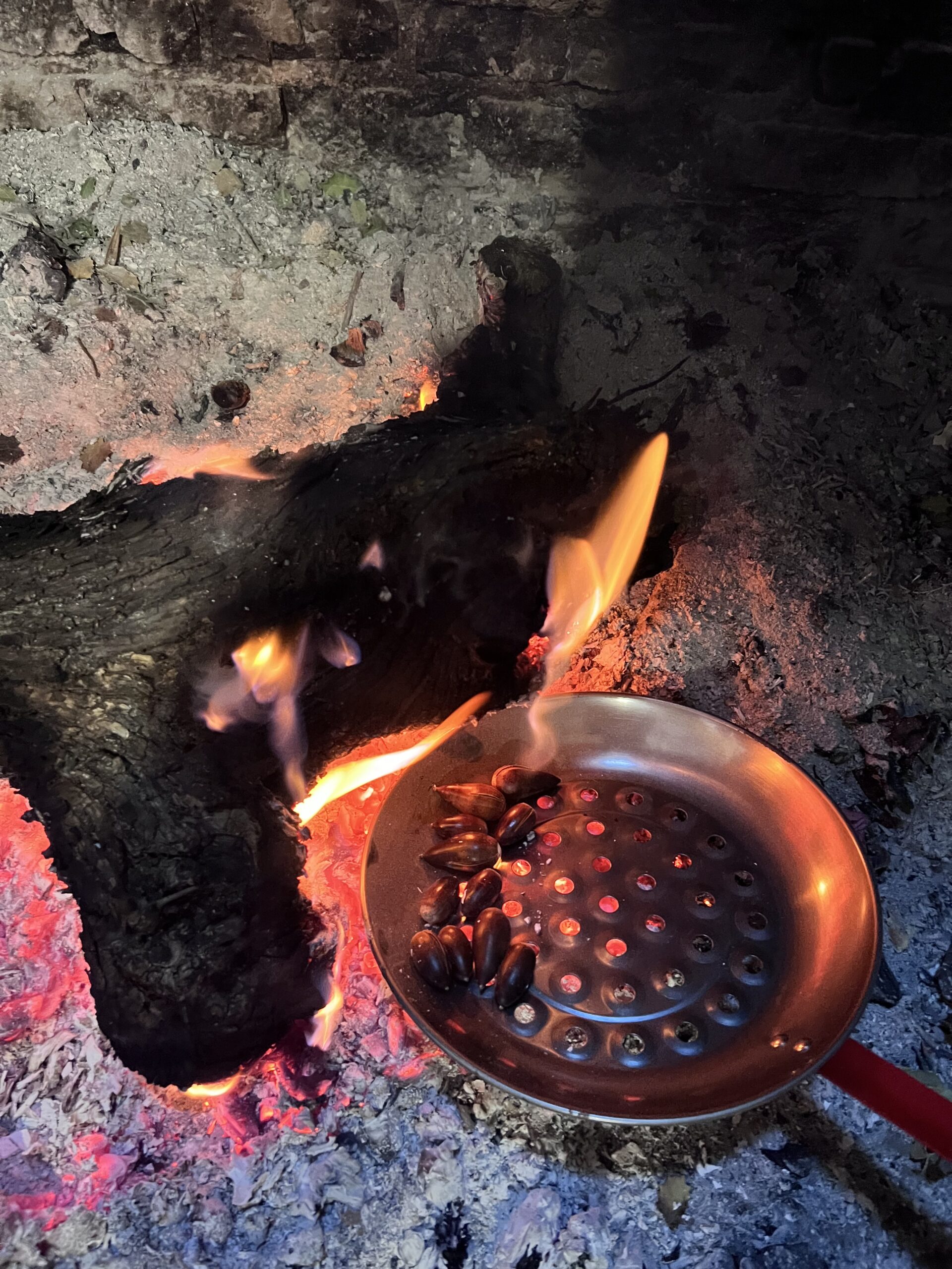
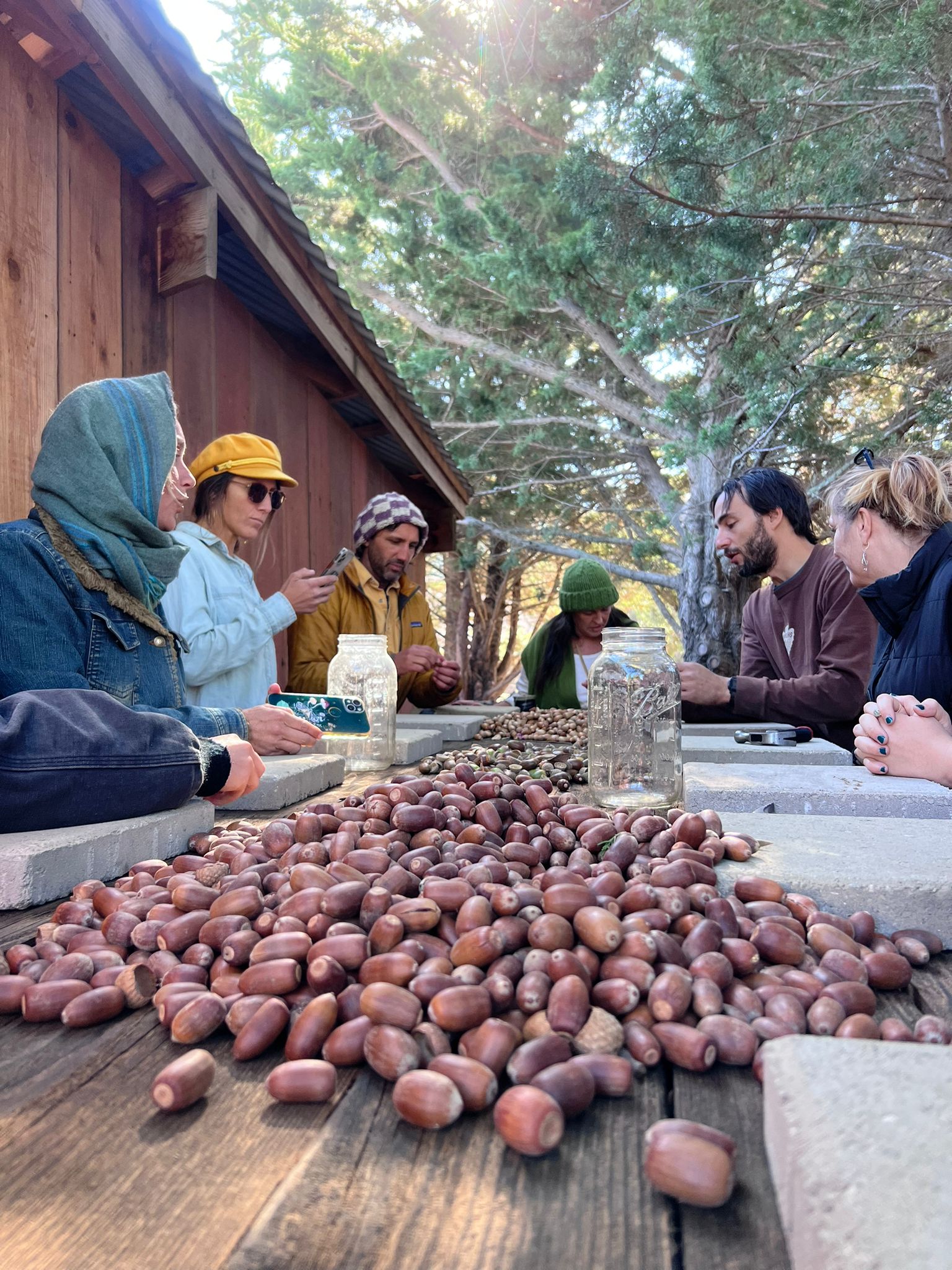
Objective 6: Research and develop acorn food production as a high-value, gluten-free, delicious flour and foodstuff (Acorn food workshop Fall 2023, First oaks planted Spring 2024)
- We collected acorns from red, white and intermediate section native oak trees, taste tested and made several recipes.
- We carried out literature reviews on acorn food practices globally and visited two active acorn producing regions and businesses in the Iberian Peninsula of Europe.
- We identified several processing steps involved in producing acorn flour and potential machinery that would be involved to produce it commercially.
Contract: 4/22-1/24: Contract oversight, administration, management tasks
1 - 12/23, 12 months: complete objective 1: Water management accounting
5-8/22: 2-4 months: all major design/ planning elements for objectives 2 through 6 for implementation-ready plans.
5-8/23: Phase 1/ first earthworks associated with Objectives 2 - 4.
3/24 (following first rain): Phase 1 planting activities-restoration and agro-ecoforestry, assuming all earthmoving has been complete (Objectives 2,3,4,5,6).
Winter 23-24: monitoring; 1st Agroforestry workshop (Objective 2;) 1 field day workshop after rain events (Objective 4)
Fall 23: Acorn food processing workshop, objective 6.
Early spring 24: One berm was planted with native food and pollinator species (fully complete Objectives 2, 5, 6)
Summer 24, 1 month: Phase 2/ complete/ remedially address issues related to earthworks and restoration activities associated with Objectives 2 - 4.
Spring 24: Project Wrap Up
Cooperators
- - Technical Advisor (Educator)
- - Technical Advisor
- - Technical Advisor
- - Technical Advisor
Research
Objective 1: Water management accounting
-
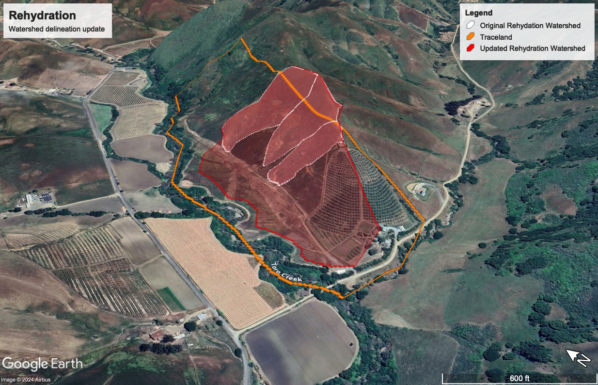
There are 7,000 acres of the Toro creek watershed located up stream of the Traceland agricultural well, dozens of land holders with riparian rights and hydrologically connected wells, and large variability of annual precipitation amounts as well as orographic differences. At 18 inches of rainfall on average, the reach of Toro creek that abuts Traceland is a perennial stream in several locations. Thankfully, the well has never had any issue with water supply over the last 20 years of agricultural and residential use, even during years of heavy drought. The catchment area of this rehydration project after recalibrating earlier figures post earthworks construction was determined to be roughly 40 acres. About two thirds of this drainage is detained above grade of the Traceland well in swales and basins, suggesting a potential increase in input to the agricultural well tap area.
-
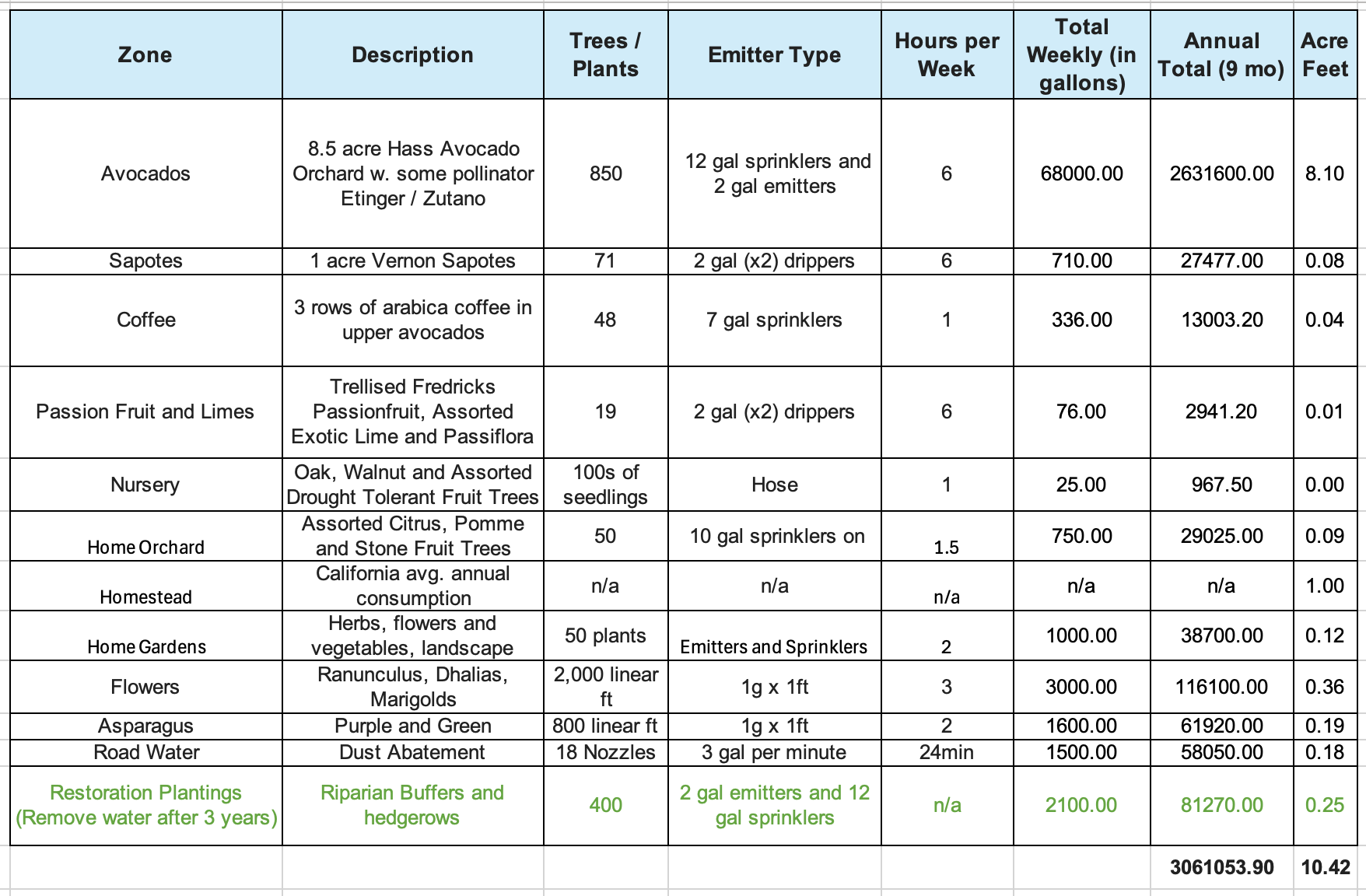
We assessed the consumptive water use of Traceland Farm to reduce the water footprint and off-set pumping from the agricultural riparian well. Water consumption was measured according to agricultural use based on observations and estimates for the 2023 irrigation year for a total of 3.3 million gallons or 10.17 acre-feet (af), less than originally estimated. This figure is discounted slightly from 10.42 af for the restoration plantings that have negligible consumption and will not require water after 2-3 years of establishment (Water Consumption Table).
-
- Materials: Irrigation consumption table
- Methods: Accounting of water consumption
Objective 2: Expand agricultural operations onto valuable Class 1 alluvial soil agricultural land and simultaneously restore native habitat across approximately 12.5 acres,
-
- Earthworks were completed August 2023.
- A second flower bed was developed on the Class 1 alluvial soil moving northward along the creek terrace using the grubbing and extra topsoil from the earthworks.
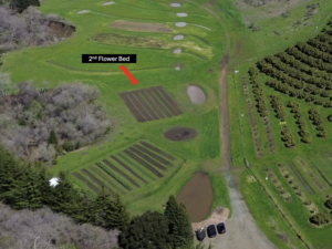
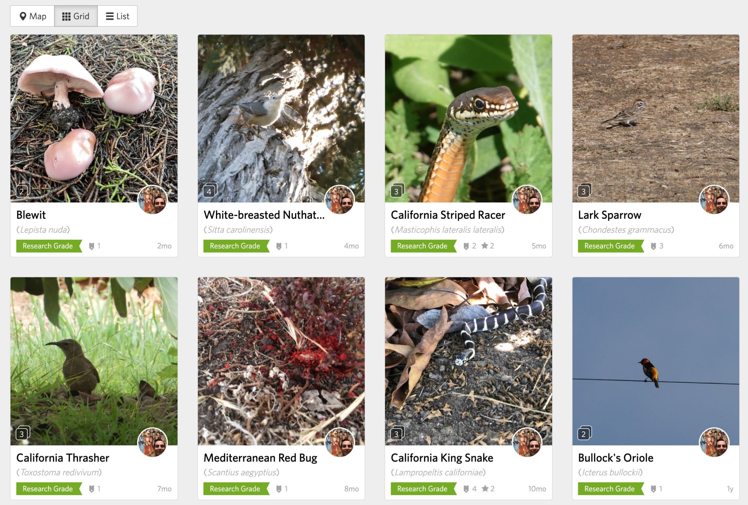
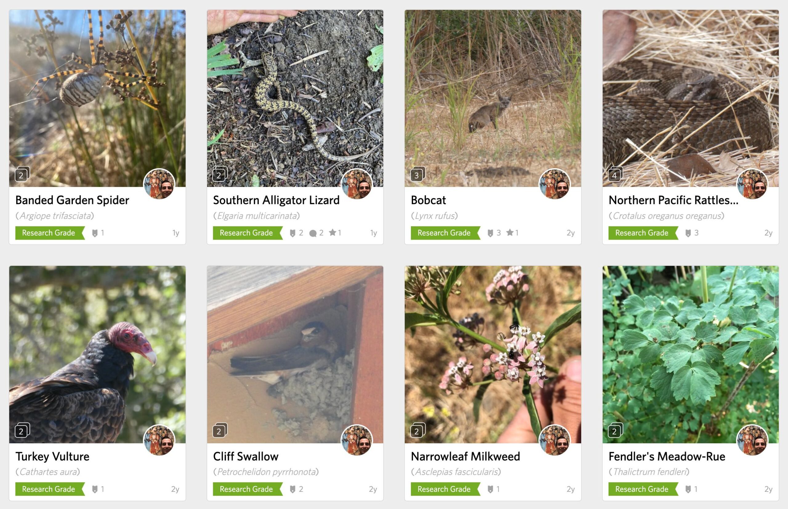
- Monitoring of the terrestrial and aquatic wildlife species response to restored habitat is being continually tracked.
- Baseline began in summer of 2019 until present contains 162 observations, 149 species, 107 of which are research grade.

-
-
-
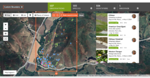
- Jesse Trace iNaturalist Observations
- Figure 1: iNaturalist Observations
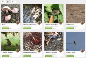
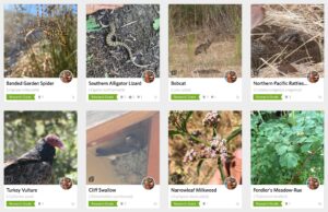
- Example 1 Observations Example 2 Observations
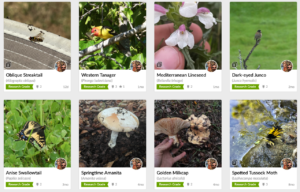
- Example 3 Observations
-
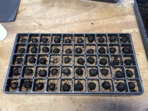
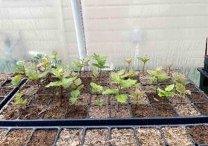
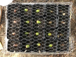
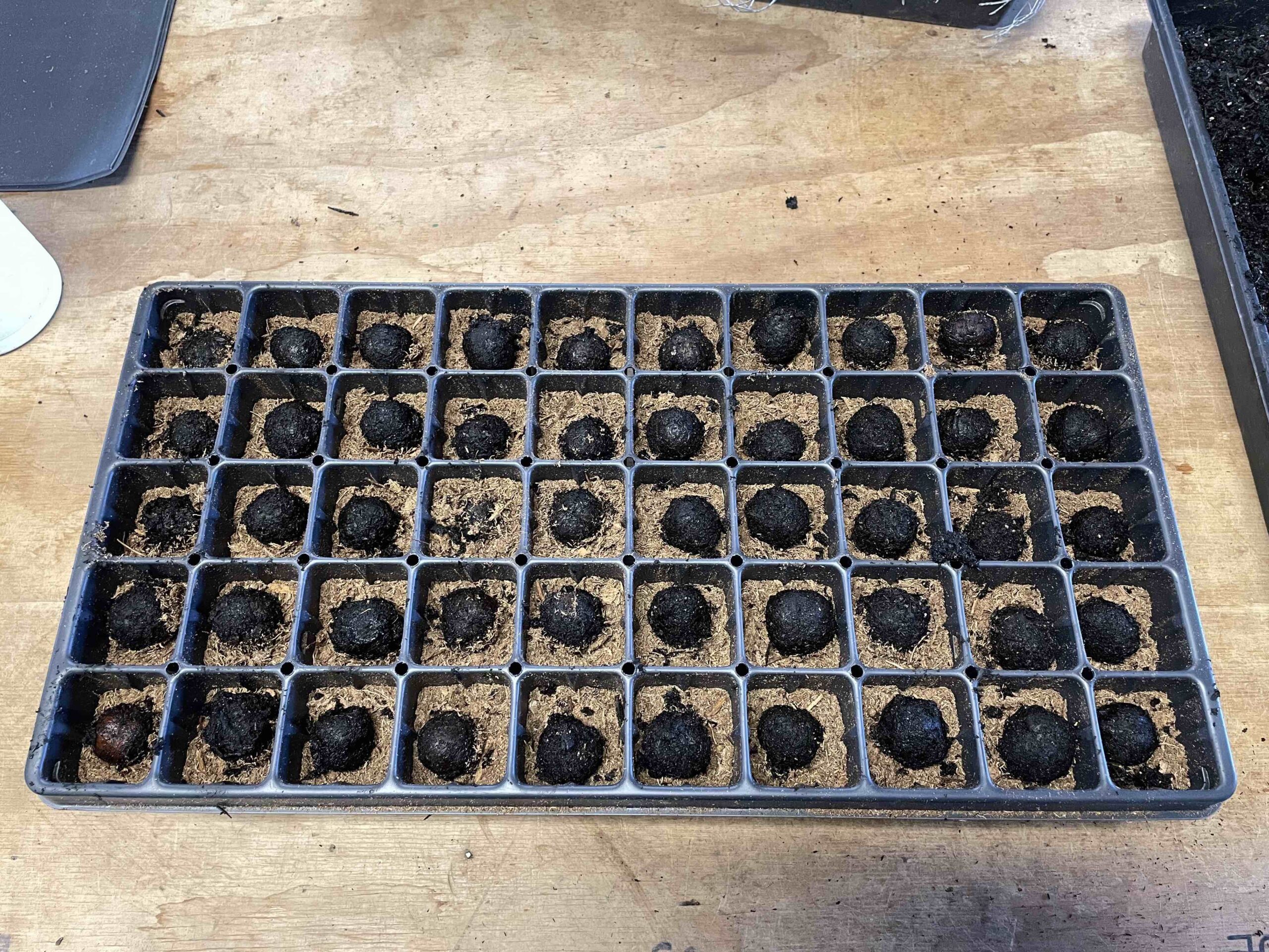
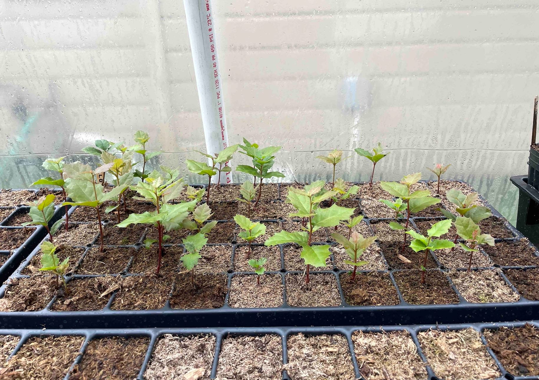
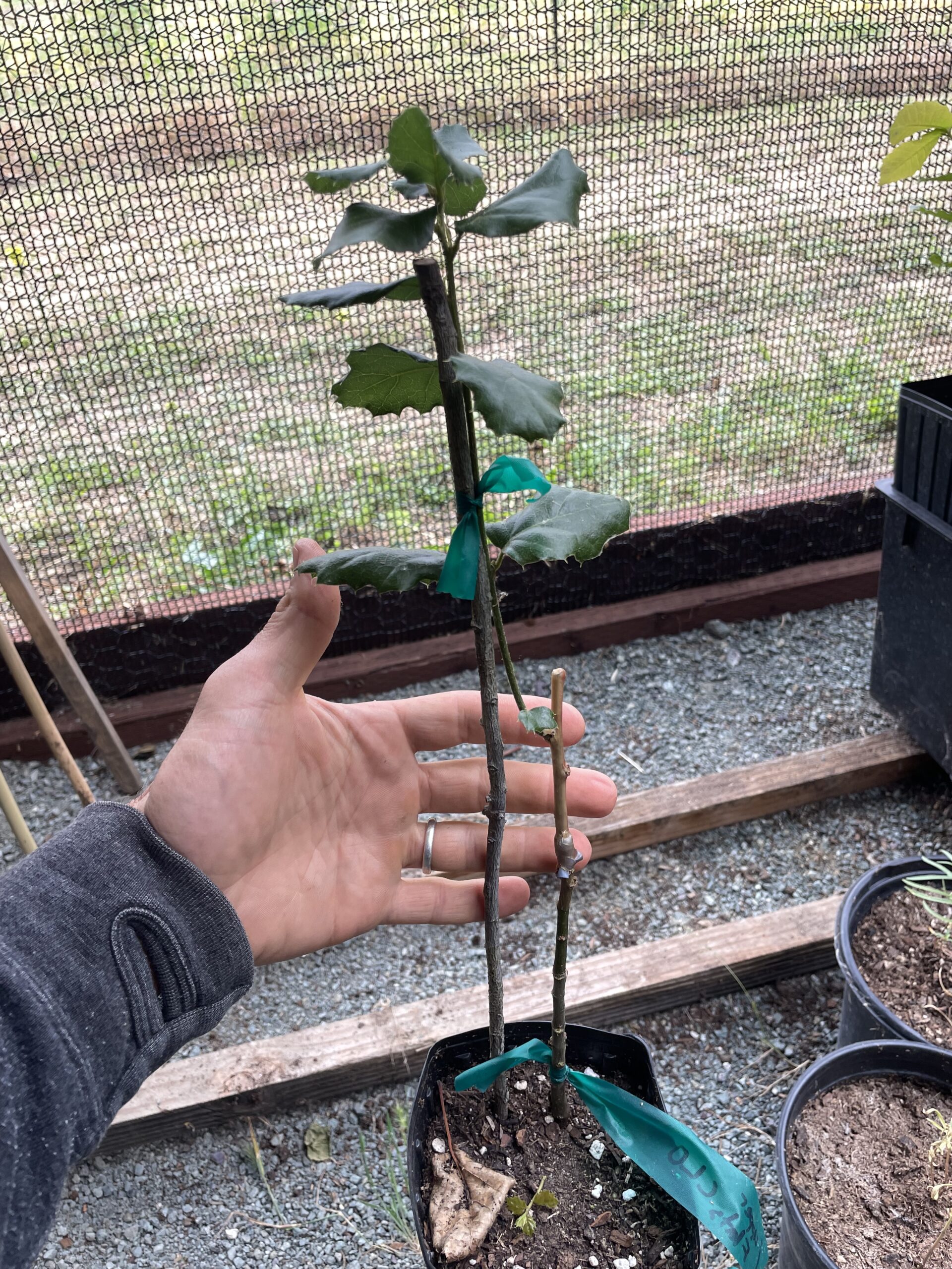
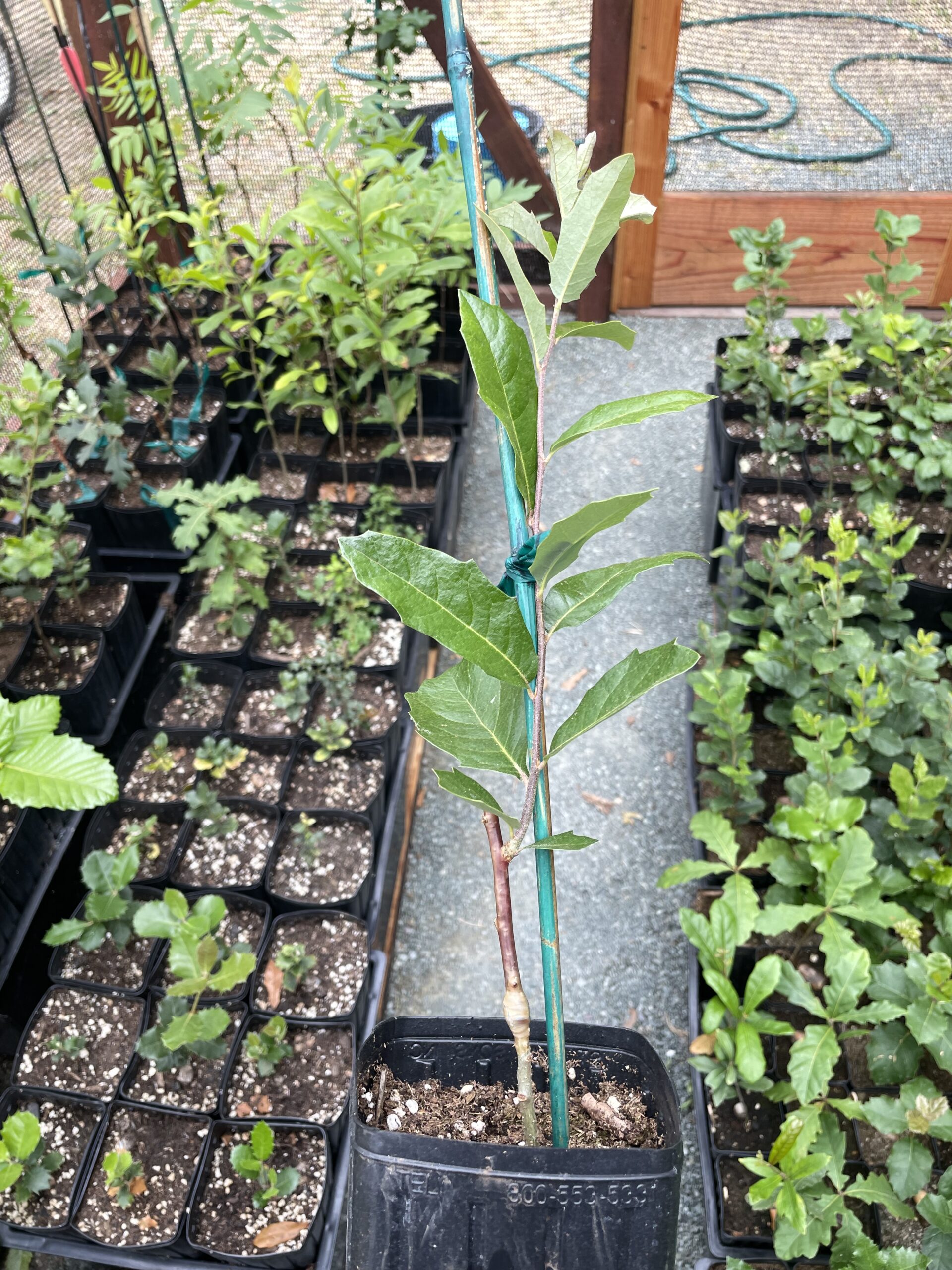
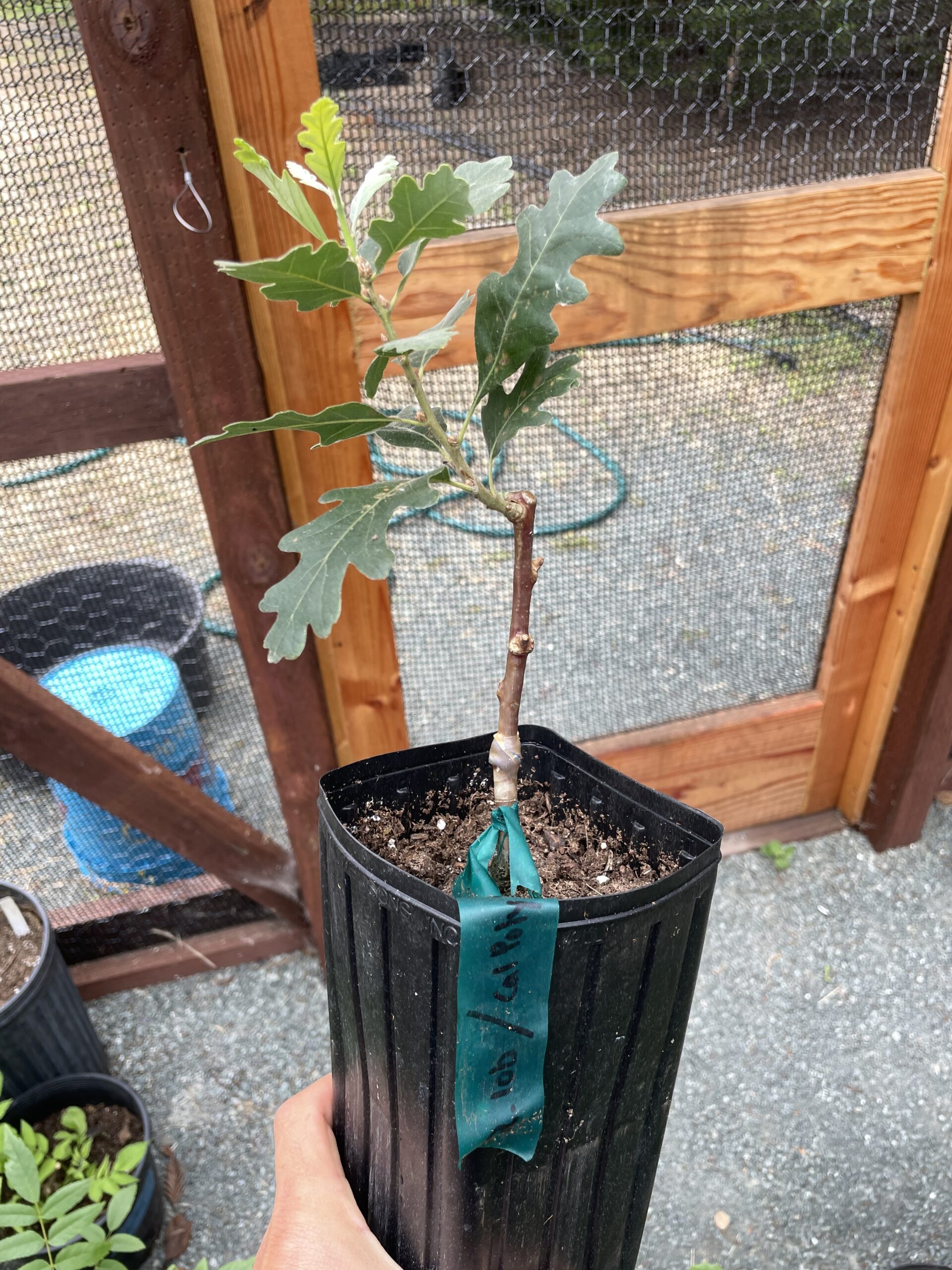
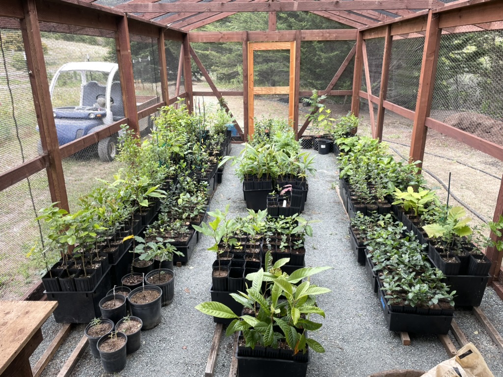
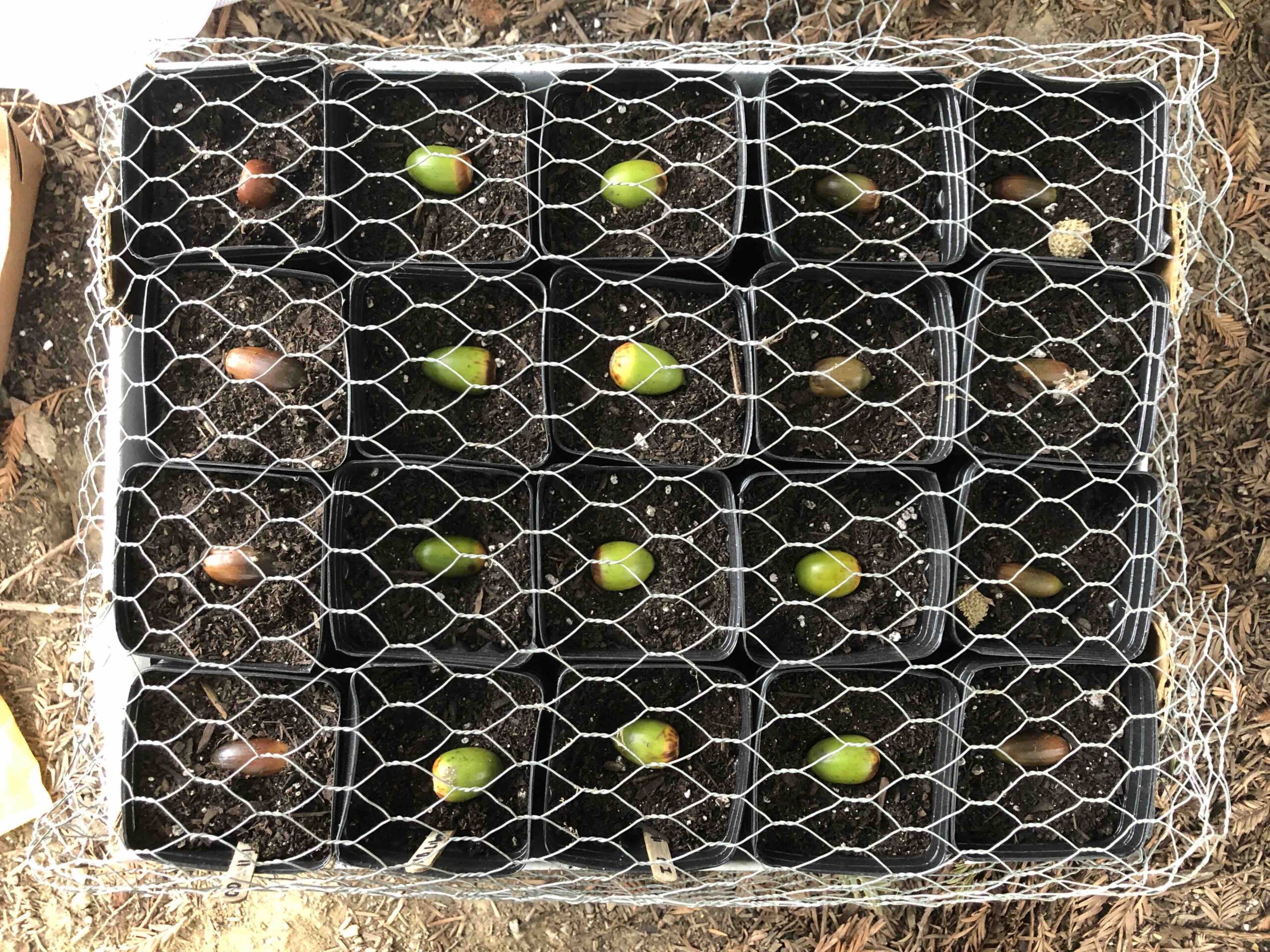
- Based on advice from the International Oak Society (IOS) and the California Conservation Corps (CCC) we decided to sow our own local and climate adapted seeds and acorns and use specialized air pruning tree pots. Change in sourcing is better quality than local nursery stock and under original budgeting cost. Plants have been germinated and are developing well. First oak grafting trials were carried out. Several native, native adjacent and non-native species were successfully grafted with the hot pipe callusing technique. This proof of concept is critical for the development of native elite oak cultivars. The nursery has grown in diversity and size and is able to supply planting efforts on Traceland as well as other ranches.
 .
.  .
. 
- Black Walnut Tray Coast Live Oak Tray Island Oak & Q. species
-
-
Nursery Pot CostsItem
Quantity
Cost
3” x 8” air pruning pot
200
139.80
3” x 8” pot container
8
71.92
4” x 14” air pruning pot
318
329.88
4” x 14” pot container
23
265.77
5” Plug Trays
2
116.60
Tax + Shipping
332.30
Total
$990.95
-
Potting Soil CostsItem
Quantity
Cost
Kellogg Potting Soil (PS)
3
35.85
Kellogg (PS) + Peat
5+1
97.81
Total
$133.66
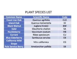
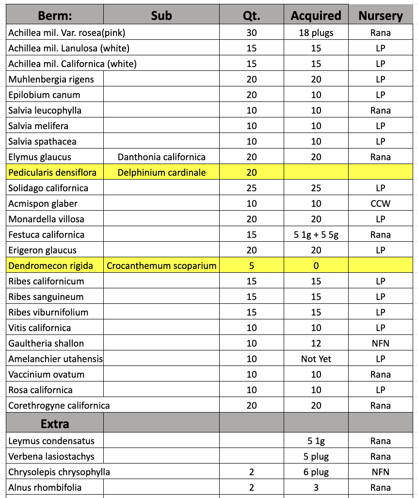
- Developed plant palette based on bioregional ecosystem mimicry: oaks, black/persian walnut, salal, huckleberry, currant, elderberry, grape, service berry, (timber, food), and found an estimate of mature oak orchard acorn production at 3.1 – 7.7 metric tons per hectare according to the book The Carbon Farming Solution, written by Eric Toensmeier, published in 2016.
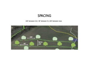
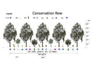
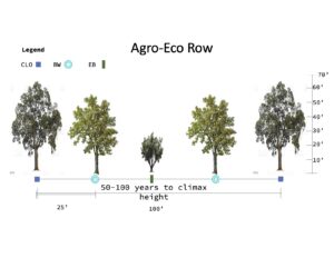
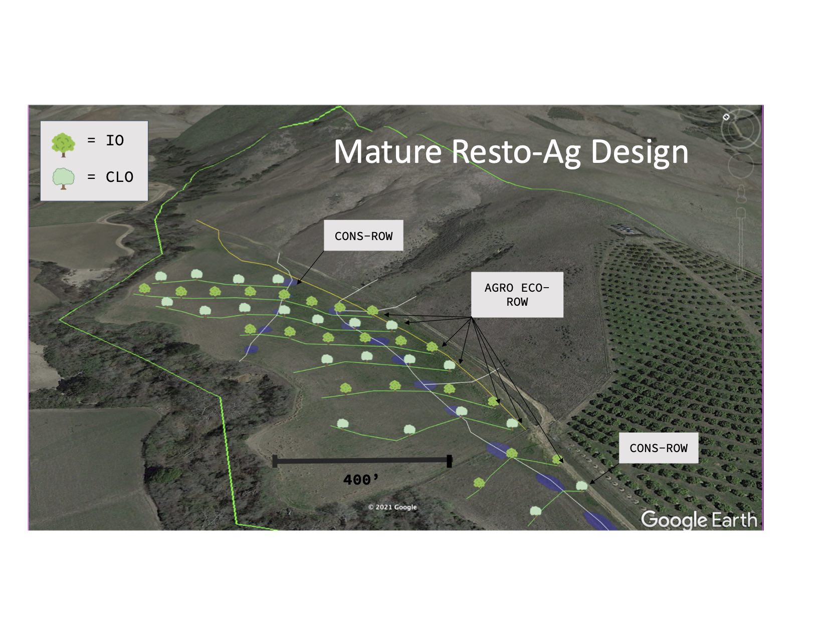
- We incorporated the appropriate sizing/spacing for conservation plantings, and agro-eco rows into the design (with alleys between trees leaving plenty of space for more intensive ag and about 30 years to do it before shaded out by mature trees)
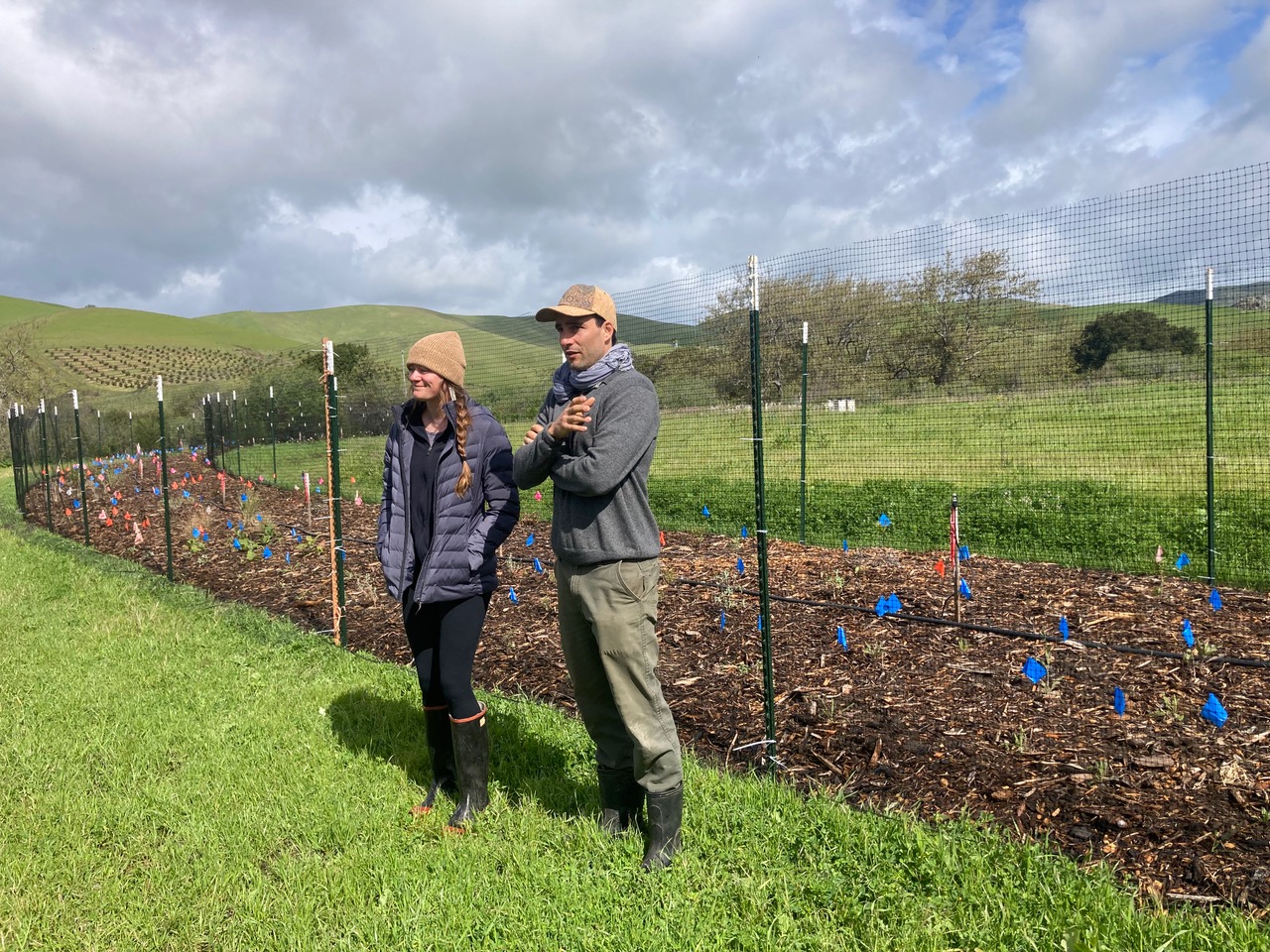
- 200 ft long 10 ft wide native food and pollinator hedgerow was established with the US-LT RCD with funding from the Wildlife Conservation Board (WCB) on the bottom most berm of the rehydration system reintroducing extirpated species and seed source according to Cal-scape distribution maps and database.
 .
.  .
. 
- Mature Design Spacing Plant Palette
 .
.  .
. 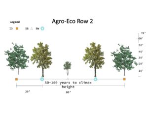
- Conservation Row Agro Eco Row 1 Agro Eco Row 2


 .
. 


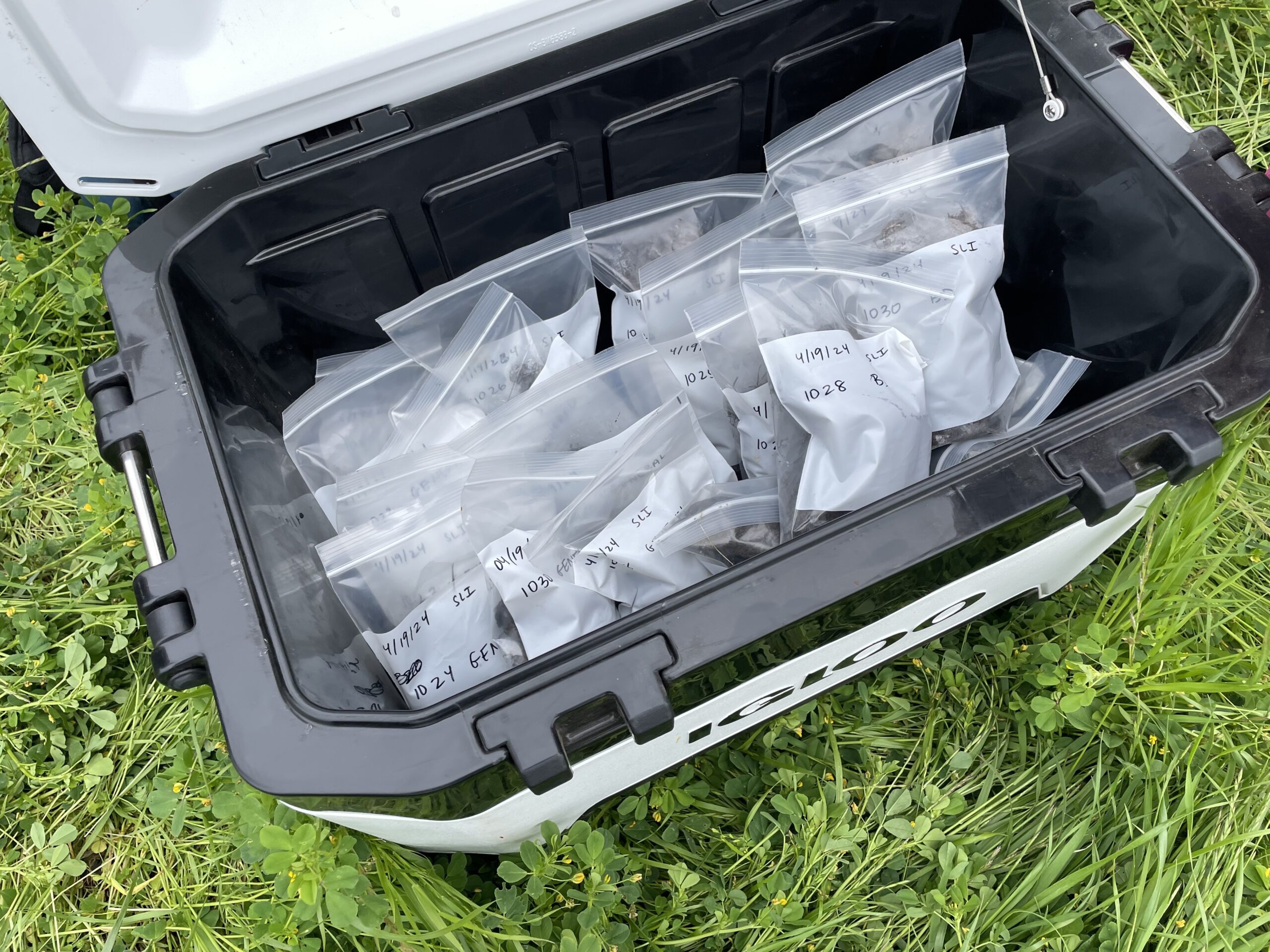
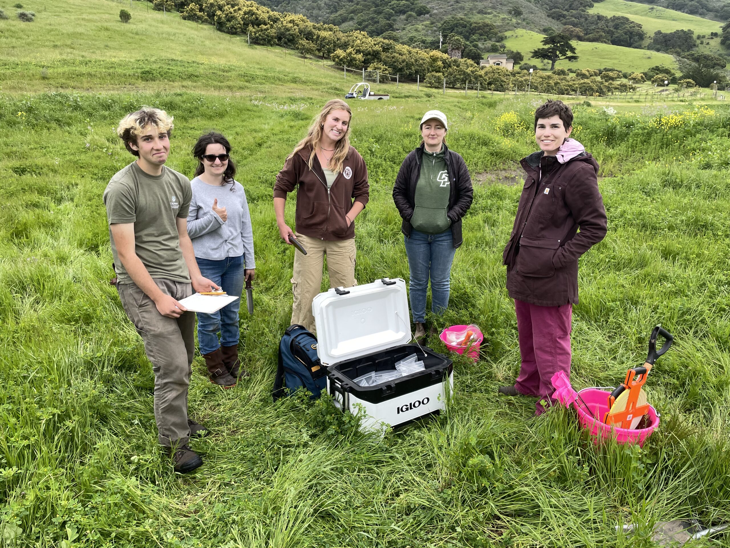
- Soil health measurements were carried out by PHD Yamina Pressler, Cal Poly Professor and soil scientist with her students in concert with the Upper Salinas Las Tablas Resource Conservation District (USLTRCD)
- 1) soil carbon assessment – total carbon, inorganic carbon, mineralizable carbon (2) soil biological assessment – nematode community composition and abundance, and (3) soil physical properties – aggregate stability, texture, gravimetric soil moisture, bulk density (clod method)
- Materials: iNaturalist project, Graphical Soil Analysis Report
- Methods: Monitor wildlife populations and upload new species onto iNaturalist as habitat develops and soil sampling with Cal Poly
Objective 3: Reduce soil erosion and stream bank collapse 0.5 miles of Toro Creek
-
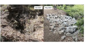
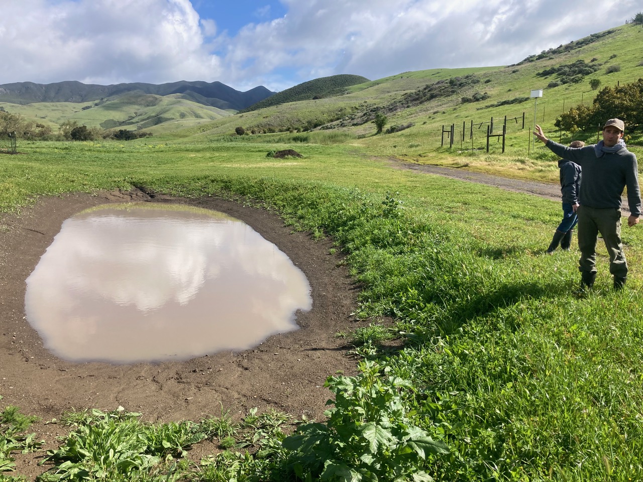
- Rehydration earthworks were completed in early August 2023. The system worked according to plan and had no issues other than minor erosion on upstream side of basins. These sluffs will be touched up summer 2024 with a skid steer.
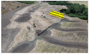
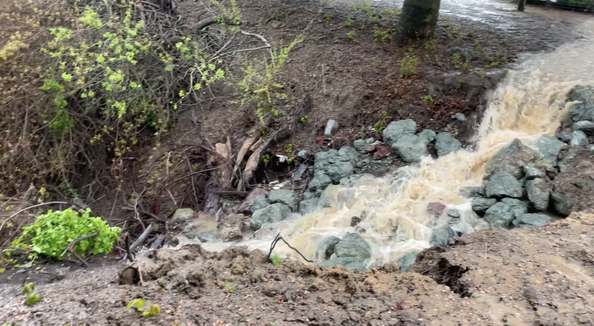
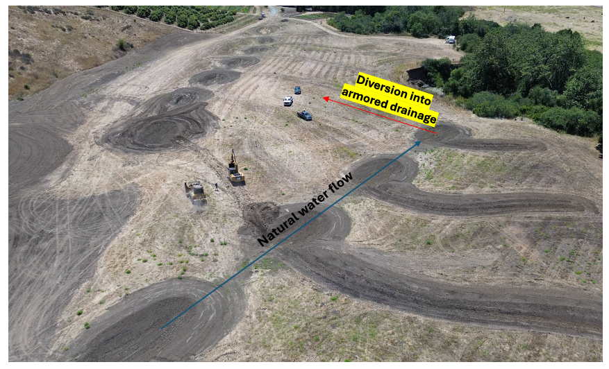
- Two main erosion gullies from the 100-year terrace ending in mainstream Toro creek have been located and assessed. All surface run-off was diverted effectively from the third ravine drainage via a distribution swale into the primary drainage with armored spillway. This was then terminated with an energy dissipation bowl to absorb any potential scouring force from a heavy storm.
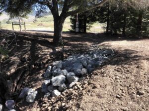
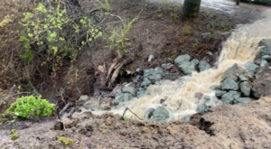
- Energy Dissipation Bowl (EDB) EDB during rain
- Materials: Camera and 100' measuring tape
- Methods: Monitor several points systematically along the creek bank and chart evolution.


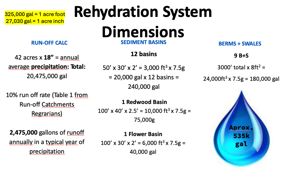
Objective 4: Capture > 500k gal stormwater run-off
-
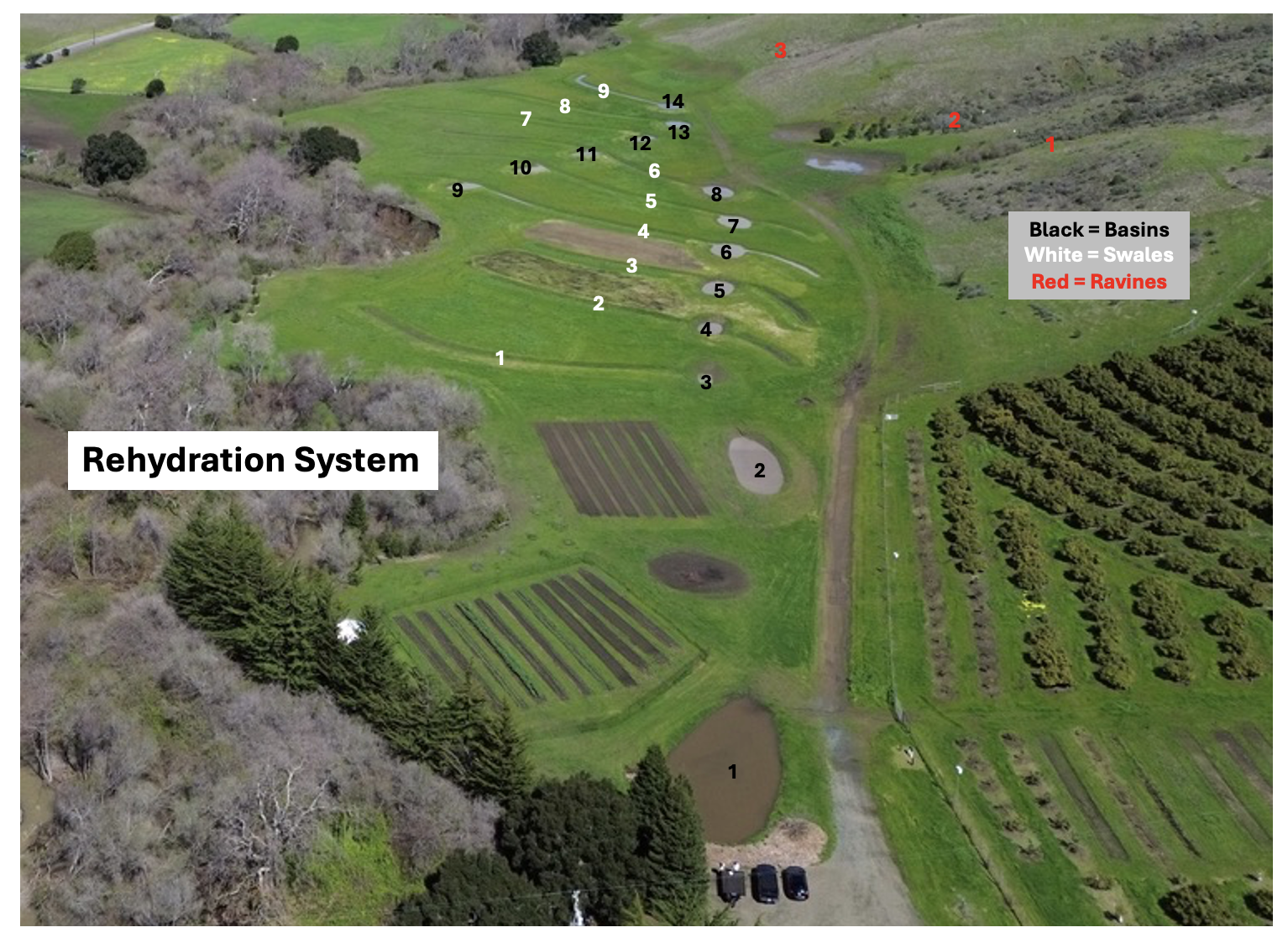
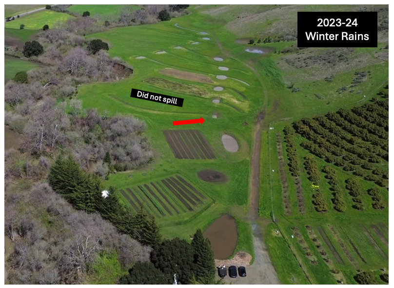
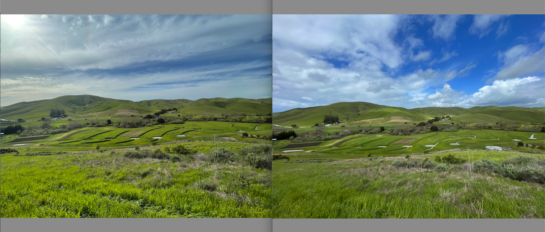
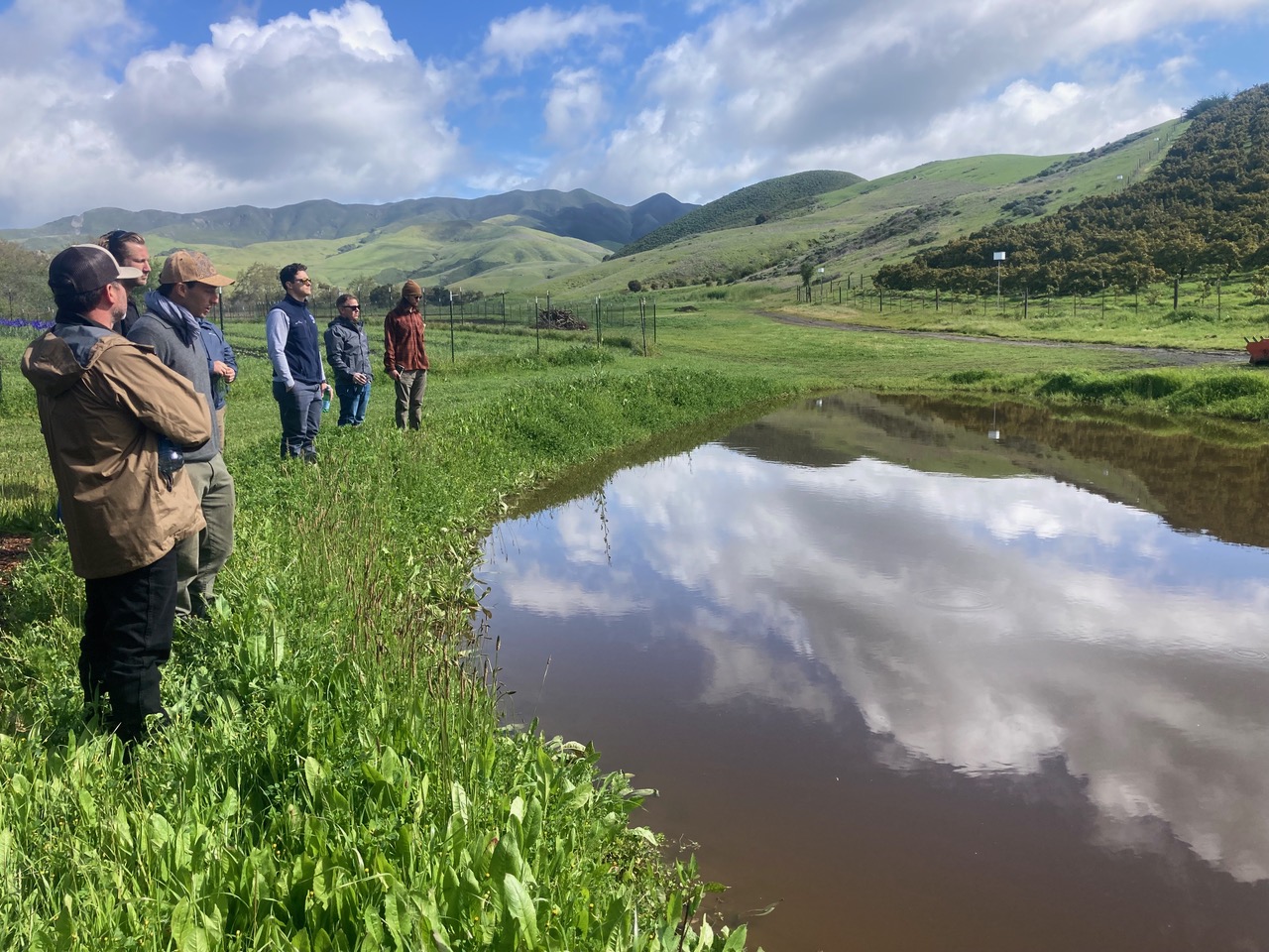
- Stepped-down, on-contour berms, swales, and recharge basins were developed according to specific topography on the ground, while maintaining roughly 100 ft between the rows for mature oak tree sizing. The run-off from the 24” rain over the 2023-24 winter did not overflow from the bottom most basin spillway. During this time the system filled close to capacity on several occasions, suggesting higher than anticipated water recharge.
- Monitoring the system, we deduced certain areas of high infiltration and potential paleo channels in some of the far reaches of the swales. We also noticed areas of high impermeability in the basin bottoms from fine silt erosion. Due to the amount of exposed soil from excavation there was significant sediment mobilization. Increased vegetative cover over time on the landscape should reduce this. There are future opportunities to utilize a keyline plow to further infiltrate runoff into the soil profile. Precaution will have to be exercised to be careful of sensitive flora and fauna recolonizing the ephemeral aquatic environment created.
- Despite insufficient budget, observational studies and measurements were performed to estimate infiltration of detained water. The total infiltration surface area of the rehydration system is roughly 50,000 ft2. A past percolation test on the 100-year flood terrace were used as a proxy to estimate water infiltration. Results of the test were 1” of percolation every 80 min. Field observations of surface infiltration varied greatly in the features depending on location. Future funding is needed to support experts to determine infiltration relative to evaporation.
-
-
- Research Question: How long does it take one inch of water to infiltrate in the rehydration system?
- Infiltration Formula: 50,000ft2 x .082 (1 inch) = 4,100 ft3 x 7.5 gal =30,750gal per 80 min
Infiltration Adapting Percolation Metrics
Field Infiltration Observation:
- In general the basin’s water surface lowered roughly 1” per day from visual observation
- 24hrs x 60min / into 80 minutes
- 80 minutes is 5-6 % of 24hrs
- 5-6% of rate of perc test
- As of May 30th, most of the basins are dry or near dry. We estimate that all features will be dry by late June 2024.
The system most likely captured more than 500k gallons of water, though it is unclear how much was infiltrated and how much evaporated. The captured surface water attracted many different wetland species and water fowl that had never visited the site such as: redwinged black birds, blue herons, American egrets, Malards, sierran chorus frogs and benthic macronveribrates.
-
- Materials: Camera for routine timelapse
- Methods: Periodic photos of basins to chart evolution of system
Objective 5: Capture and bio sequester atmospheric CO2
-
-
- We determined that investigating how oak woodlands and dry farmed perennial tree crop species contribute to and use groundwater was beyond the scope of this project.
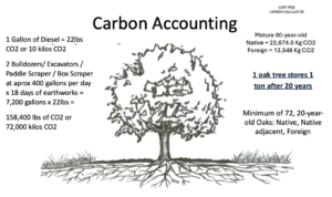
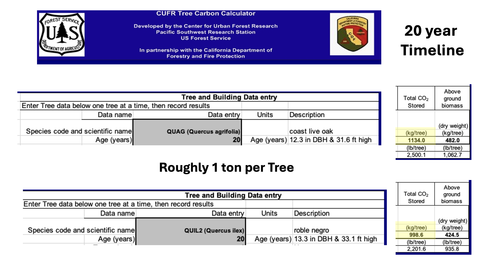
- The carbon footprint of the project’s activities was accounted for to neutralize its emissions via hardwood tree planting. Excavation of the rehydration system took longer than predicted and hence, emitted more CO2. Total workdays with two operators and two machines amounted to 18. The total CO2 emitted during the project was 72,000 kg. Including the lower sequestration rates of foreign oak trees, this project will reach carbon neutrality in 20 years from 72 oak species based on the CUFR calculations.
-
- Materials: CUFR Tree Carbon Calculator.
- Methods: Calculate annual carbon average to offset earthworks emissions.

- CUFR Calculator Carbon Capture
Objective 6: Research and develop acorn food production as a high-value, gluten-free, delicious flour and foodstuff.
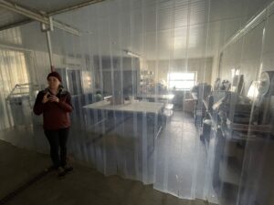
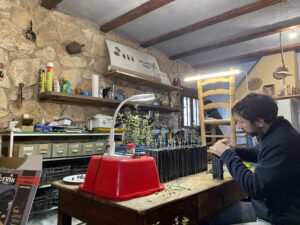
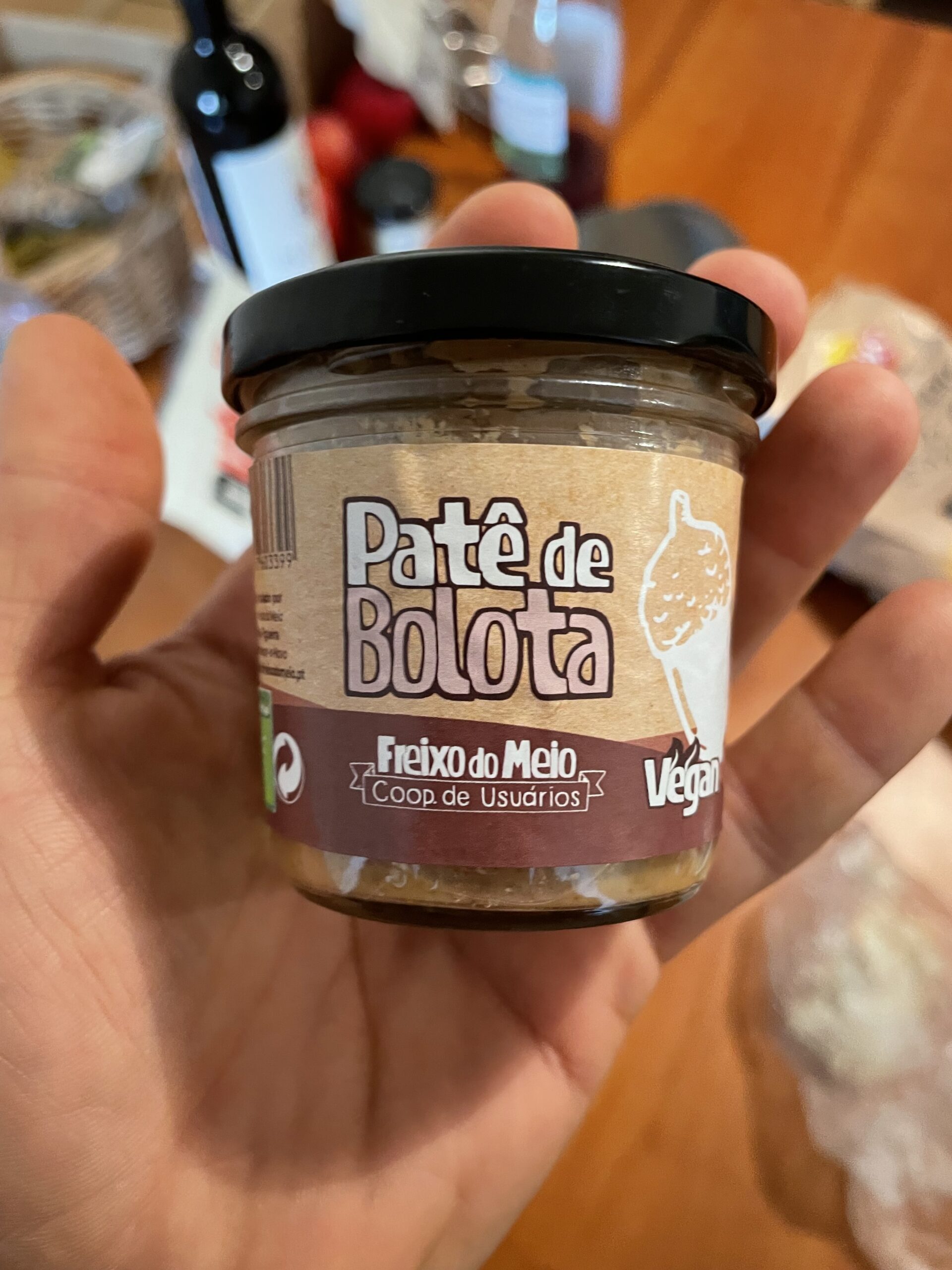
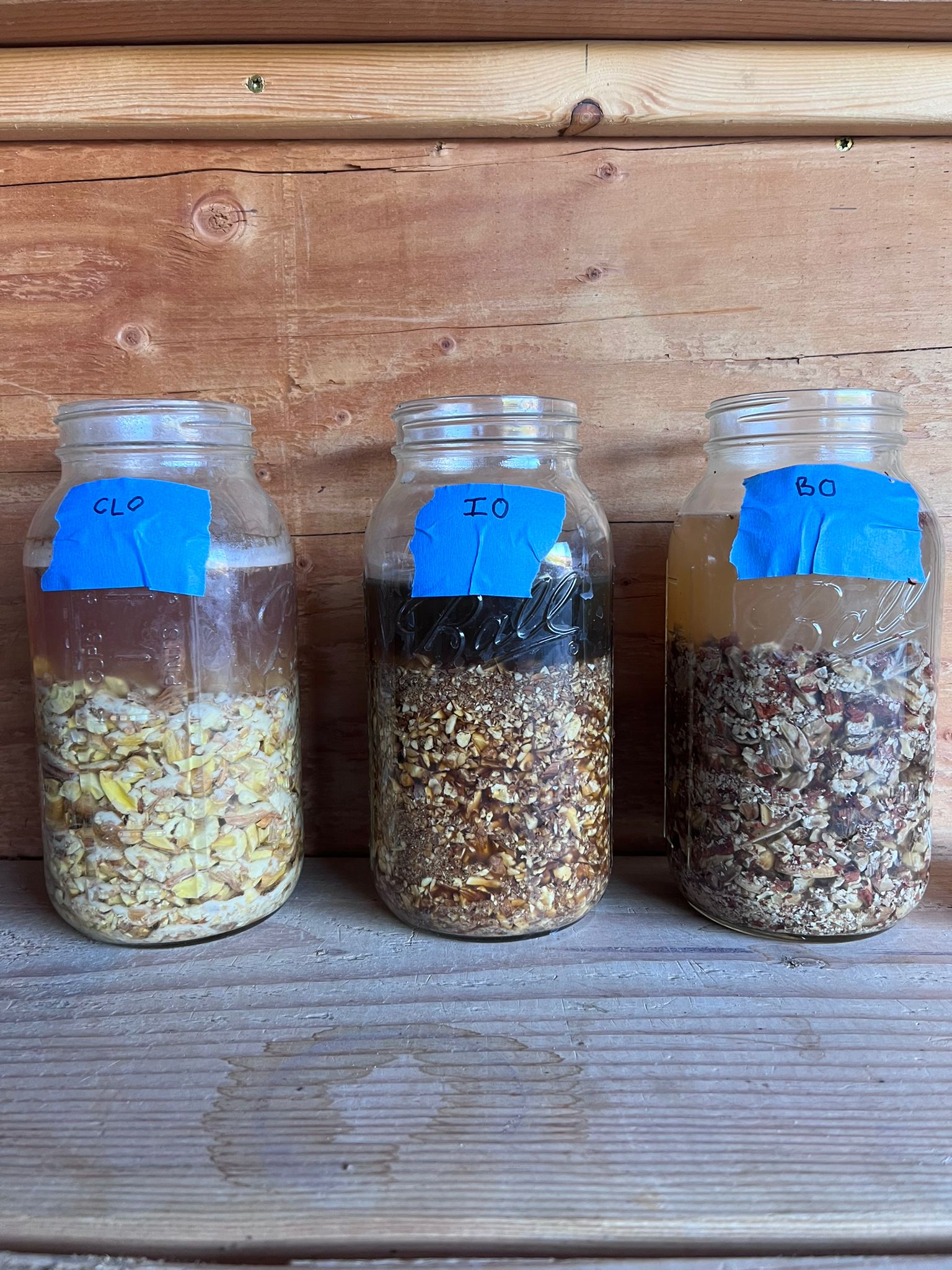
- In December 2022, we visited the Portuguese oak dehesa agroecological farm Freixo do Meio that specializes in commercializing acorn foods as well as other woodland products. A realistic first commercial harvest was determined to be within 10-15 years of initial planting based on high yielding sweet acorn oak cultivars. A literature review has been conducted to conceptualize value-added acorn products and harvesting methods to improve efficiency of production. Acorn recipes have been developed from local species to target flavor profiles and culinary opportunities and the first steps in developing local elite oak cultivars have been taken.
- In December 2023 we visited Balanotrees near Tarragona Spain. They were very helpful in demonstrating their work-flow for vegetative propagation of elite oak cultivars. We also tried several acorns from these prized cultivars and were impressed with their size, shelf life and delicious flavor of the acorns.
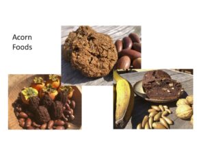
- Acorn Recipe Experiments


- Materials: 5 Gallon Bucket, Nut Wizard, Scale
- Methods: Gather acorns from local trees, leach and taste test in various recipes. Visit and taste test acorns from European leaders.
Objective 1: Water management accounting
- The downstream neighbors have taken interest in the wholistic design and water management system and have agreed to develop catchment basins on their flats. A conceptual framework was developed for water conservation, streamflow enhancement, and benefits to riparian floodplain habitat according to the principles of keyline farming design.
- There was insufficient funding to determine hydrologic connectivity from Creek Lands Conservation staff hydrologists. Nor were we able to work with any Cal Poly professors to develop estimates of groundwater recharge from the system. Nevertheless, considering the relatively small size of the catchment area, the impact is likely to be acute and insignificant on the agricultural well in relation to the Toro creek watershed.
Objective 2: Expand agricultural operations onto valuable Class 1 alluvial soil agricultural land and simultaneously restore native habitat across approximately 12.5 acres,
- Conceptualized and finalized planting plan to establish native-dominant keystone plant communities on terrace/100-year floodplain and adjacent hills to enhance botanical biodiversity and increase wildlife habitat complexity. The plan integrates productive agricultural ecosystems (e.g. edible landscape) that emphasize the diversity and functions of natural ecosystems and integrate soil health elements.
Objective 3: Reduce soil erosion and stream bank collapse 0.5 miles of Toro Creek
- The 2023-24 rain was above average with 24” and presented virtually no erosion. The system effectively diverted the original drainage causing head cutting, captured all of the mobilized sediment in the basins andand dissipated the excess water energy in the improved armored system spillway. There are several local landowners that have visited the rehydration system and have requested development of their own adapted to each properties unique conditions.
Objective 4: Capture > 500k gal stormwater run-off
- The rehydration system functioned according to its planned design. It successfully captured and detained run-off water and sediments from the upper slopes on the 100-year flood plain according to the models of Brad Lancaster in Rainwater Harvesting for Drylands and Beyond and Mark Shepard in Restoration Agriculture and Water for Any Farm. The project budget only allowed for observational studies of functionality.
Objective 5: Capture and bio sequester atmospheric CO2
- Total emissions were calculated to be 72,000 kg. This project will reach carbon neutrality in 20 years from 72 oak trees of native and foreign species.
- Contacts have been made with Cal Poly professors, Resource Agencies, local ranchers and local city governments to plant oak trees in rangelands and develop silvopasture systems. These efforts align with their goals of habitat restoration, carbon sequestration and climate resilience that come from the slew of other ecosystem services trees provide. Involving these bigger players will ensure funding and the appropriate follow up to study and integrate carbon accounting and footprint understanding to other farms and working ranches.
Objective 6: Research and develop acorn food production as a high-value, gluten-free, delicious flour and foodstuff.
- Information was compiled regarding acorn food production globally. A network of acorn food producers locally and globally has emerged from this research. The industry has promise, particularly in Spain, where the dominant species has many of the desired qualities in an agricultural product including flavor, annual yield and acorn size. Partnership between California and Mediterranean actors is imminent.
Research outcomes
This project has developed and implemented a holistic design approach to managing runoff water, restoring ecosystems, and the creation of a perennial crop agricultural commodity. These practices are based on tried-and-true keyline water management design and agroecological science. The long-term implications of this perennial, drought tolerant, food system will take decades to bear fruit. This silvopasture model will function within a successional, extensive, agro-ecosystem, mimicking the oak savanna it is established in, and endure for centuries. The result will be a landscape that increases its soil fertility and ecosystem function, rather than degrading it. The system will also function as a nursery and genetic bank for the replication of this model across California with the development of locally adapted elite oak cultivars for human and livestock consumption.
Objective 1: Water management accounting
Understanding how to manage a budget is the foundation of a healthy business. Water is the main currency of irrigation farming in the arid west. Therefore, accounting for and properly managing water resources at the farm level is paramount for sustainable agriculture. This project has developed a process that is easily adaptable for farmers and ranchers in the West. This model applied to lansacpes with landowners and farmers across California has an enormous potential to improve water quality through sediment reduction and recharge aquifers to meet groundwater basin sustainability targets.
Understanding the context of the watershed the farm is located within and the potential of the landscape to capture and store water in alluvial soils are basic resource questions that need to be answered going forward. Considering that many streams in arid climates are disconnected from their original flood plains, ag lands need to be regarded for their potential to capture water just as much as to capture agricultural revenue. Furthermore, the non-linear threats associated with the future in a changing climate, this model presents an approach to improving water resilience for western landscapes.
We hope to incorporate water infiltration studies in future projects, especially as it relates to Groundwater Sustainability Plans.
We recommend the adoption of water budgeting practices for farmers, ranchers and resource conservation agencies to paint a clear picture of weaknesses and opportunities regionally. These studies should be aligned with the goals of Groundwater Sustainability Agencies to help reach their targets and rebalance the water budget to the extent possible in critically over drafted basins.
The budget of the project was inadequate to pay for test wells and piezometers to track the water on its path into the aquifer. We recommend future studies to understand groundwater recharge values through hydrologic measurement to get a clear sense of these dynamic systems.
Objective 2: Expand Ag Land to Class 1 soil and restore habitat on 12.5 acres
We developed a second flower field and restored the bottom most berm (200’ x 10’) with a native food and pollinator hedgerow. Despite exhausting the project budget, we were able to work with the local resource conservation agency to at minimum establish a conservation agriculture and seed source reintroduction zone. This habitat restoration activity is crucial to reverse the dwindling populations of pollinators and wildlife by inserting food source at the base of the trophic chain. Observations from the biological baseline suggest that many species have been extirpated from the area through land use and land cover change since european settlement.
Oaks were established on the lower most berm and a plan was developed to plant out the remaining berms over time. This oak woodland restoration will be partially dedicated to banking elite oak cultivar genetics for clonal tissue propagation and establishment in cattle pastures throughout California. Three oak categories were determined for use in the genetic bank.
- Native
- Native Adjacent
- Foreign
These species should be carefully studied to determine risks and benefits for future agriculture and restoration use in the arid west. Future funding will be necessary to identify, domesticate and propagate useful oak species for silvopasture, non-timber forest product, and intensive balanced carbohydrate crop production applications.
Considering that oak woodlands are in decline in mediterranean climates globally it is important to be proactive in their restoration and in innovating ways to add value sustainably to these fragmented ecosystems. This project has initiated a process to solve this important problem in western ranches. We recommend that future studies focus on an agroecological approach to production and the careful incorporation of ecosystems and their services, directly into agricultural systems.
Objective 3: Reduce creek bank erosion
The catchment system did not overflow from ravines 1, 2, and 3. Therefore, all sediment mobilized from winter rains was deposited in the basins and swales, rather than spilling over the edge of the bank of Toro Creek. The diversion of the third ravine drainage into that of the first and second arrested the head cutting and its associated erosion. The energy dissipation bowl at the bottom of the system was increased in size and capacity.
This thoughtful management of drainage on ag lands has the potential to reduce erosion and improve water quality across the West, especially in areas with pronounced summer drought and disturbed soils. Riparian and aquatic species could benefit from the reduction of sediments into their habitat. For example, endangered steelhead trout habitat is affected by sediment mobilization by filling the spaces in between gravel that eggs are laid in (aka redds) and also decreasing water oxygen levels for fry and alevin.
Future studies should determine the precise amount of sediment captured from runoff scouring as well as the reduction of head cutting on riparian banks. The incorporation of erosion reduction techniques would also restore ephemeral habitat on uplands.
Objective 4: Capture 500k gal of runoff water
The rehydration system was successfully completed mid 2023 and worked according to plan. The system detained every drop of water from its three-ravine catchment area and stopped it from spilling into the creek, despite having an above average rain year of 24”. The lower two basins that drain the avocado orchard spilled several times into the EDB. A wide variety of wildlife was attracted to the area due to the presence of water on the landscape. This has persisted until the summer solstice more or less.
Due to insufficient funding, only observational measurements were taken. Infiltration was slowest in basin bottoms, where mobilized silt and sediments settled. Certain areas presented higher infiltration than others, especially far reaches of the on-contour swales.
Capturing runoff water on a broadscale could reduce velocity in creeks and rivers during the high flow time of year in mediterranean California. This can enhance dry season flow as water seeps through the sub-soil and into the riparian zone later in the year.
Future studies of rehydration systems and their groundwater recharge should attempt to measure nearby stream flow to demonstrate hydrologic connectivity and change in flow. These studies should be carried out on smaller drainages where the impact on late season streamflow can be easier to measure.
Objective 5: Capture and bio-sequester carbon emissions from earthworks
Insufficient funds and time constraints impeded oak and walnut planting activities. Furthermore, research on clonal tissue propagation and interesting alternative oak species required new calculations to determine sequestration rates from said cultivars. This also spurred the decision to in-house oak and walnut tree production to ensure local seed source, secure rare and unique cultivars and to assure plant health. Oak grafting will greatly reduce time to fruit and ensure desired genetic characteristics. We are one of a very few practitioners in the west coast performing grafting on hardwood species.
Calculations were made using the CUFR carbon calculator. The study concluded that it would take 36 native oak species and 36 foreign oak species at 20 years of age to absorb the carbon emitted from the earthworks portion of this project.
Carbon emissions from agriculture have been estimated to account for as much as 1/3 of all global atmospheric CO2 equivalents. Like water budgeting, understanding the scale of emissions at the farm level is an important step in managing resource use and externalities at regional and national levels. Long-lived hardwood trees are ideal candidates for sequestering atmospheric carbon.
Future studies should determine actual levels of CO2 sequestration in native and nonnative Quercus species in silvopasture systems.
Objective 6: Research and Develop Acorn food
For the last several years, efforts have been made to visit, harvest, process and taste test native oak species in SLO county and beyond. What was once an abundant resource of past human settlement, acorns are now relegated to yard waste and liabilities in urban landscapes. However, there are examples of reignited interest in California native food way revival, homesteading circles, and in Europe’s mediterranean region.
Since many of the free-standing oak trees on creek terraces have been removed to “improve” agriculture, it has been difficult to find exemplary trees and estimate their yield. However, Iberian counterparts have multiyear trials in various universities and think tanks and have arrived at a figure on par with wheat yield globally at one ton per acre. Spanish contacts have also shared their techniques of identifying useful cultivars. The process is as follows:
- Visit oak trees with desired characteristics (large, sweet acorns)
- Revisit annually over three years to track annual yield quality and quantity
- Collect tissue, propagate and name cultivar (if not already named)
Visits to Europe took place in winter 2022 and 2023 to connect with researchers, see acorn processing machinery, taste various products, learn propagation techniques and taste acorns from elite oak cultivars. All this work was done by the PI out of pocket. Considering the emerging market in mediterranean Europe, we recommend future studies in the western U.S. regarding this overlooked and drought tolerant food source.
Cal Poly SLO is moving towards reforesting its rangelands and restoring historic oak populations. We also recommend developing this academic partnership to innovate within climate smart agriculture and uplift elite oak cultivars and sweet acorns as a future high-value commodity for California and other mediterranean climate regions. The PI is leveraging partnerships established from this grant to apply for future funding for the WSARE Research and Education pre-proposal titled, SLO County Rangeland Silvopasture, Carbon and Agricultural Biodiversity Enhancement.
Education and Outreach
Participation summary:
Education and outreach for the project consisted of two workshops and two lectures:
Lectures:
- Oak and Acorns as a staple food (x2)
-
https://www.youtube.com/watch?v=8FWrHRxFCDU&t=836s&ab_channel=JesseTrace
Workshops:
- Oak and Acorn food processing workshop
- Restoration and Rehydration workshop
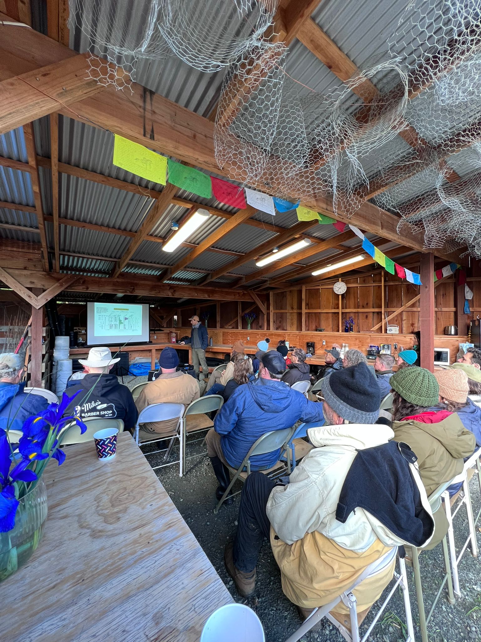
The first lecture took place May 2023 in the Morro Bay public library. The second lecture was March 2024 at the SLO public library. The first workshop was held November 11th, 2023 at Traceland with a local herbalism class, Wild Beauty Ayurveda. The second workshop took place April 5th, 2024 at Traceland and recruited people from across SLO county. Participants included resource conservation agencies, farmers and ranchers, environmental landscapers, watershed conservation organizations, local stakeholders and colleagues.
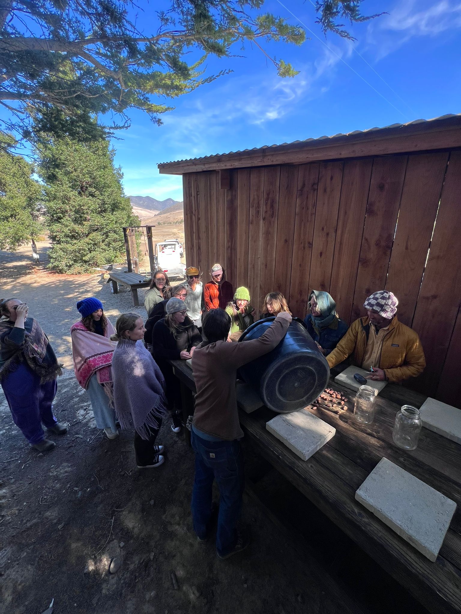
The rehydration and restoration workshop was a great success in terms of turnout and interest in the content. The agenda was composed of three parts:
- An overview of the farm story, big problems and theory
- A site walk to see the work in practice
- A lunch and social for stakeholders to connect and digest the concepts
This methodology was beneficial in that it allowed the presenter to develop the reasoning behind the design as an attempt to try to resolve some of the problems caused by modern agriculture like environmental degradation and biodiversity loss. We were then able to present systems level practices such as keyline design, scales of permanence, ecosystem biomimicry and water management to remediate these issues and establish a structure that is inherently resilient to shocks.
Once the problem and reasoning were expressed the focus then turned to how to develop these systems depending on the local context and the perennial challenge of funding for the small family farm. This dovetailed well with the blending of restoration and agriculture in extensive farming systems and opportunities to work with resource conservation partners to make the task less onerous on the landowner.
Within this framework, the results from the design were the logical outcome of a system that generates positive ecological benefits along with economic returns. It is baked into the system. It was critical to visit the site in early spring when water is still present on the landscape in mediterranean climates.
We recommend workshops that clearly define the problems being tackled, the technical methods used to resolve them, and visits at critical windows to see the models in action and comprehensively absorb the modality used.
Education and Outreach Outcomes
The rehydration and restoration workshop was a great success in terms of turnout and interest in the content. The agenda was composed of three parts:
- An overview of the farm story, big problems and theory
- A site walk to see the work in practice
- A lunch and social for stakeholders to connect and digest the concepts
This methodology was beneficial in that it allowed the presenter to develop the reasoning behind the design as an attempt to try to resolve some of the problems caused by modern agriculture like environmental degradation and biodiversity loss. We were then able to present systems level practices such as keyline design, scales of permanence, ecosystem biomimicry and water management to remediate these issues and establish a structure that is inherently resilient to shocks.
Once the problem and reasoning were expressed the focus then turned to how to develop these systems depending on the local context and the perennial challenge of funding for the small family farm. This dovetailed well with the blending of restoration and agriculture in extensive farming systems and opportunities to work with resource conservation partners to make the task less onerous on the landowner.
Within this framework, the results from the design were the logical outcome of a system that generates positive ecological benefits along with economic returns. It is baked into the system. It was critical to visit the site in early spring when water is still present on the landscape in mediterranean climates.
We recommend workshops that clearly define the problems being tackled, the technical methods used to resolve them, and visits at critical windows to see the models in action and comprehensively absorb the modality used.

Runoff water management and water energy dissipation
The secondary and tertiary benefits of groundwater recharge, livestock water and habitat
Attitude changes towards landscape level modifications without fear of regulatory agencies or permitting quagmires