Final report for GNC20-309
Project Information
Effect of recurring flooding on greenhouse gas emissions, soil C and N contents and forage quality in grazing and hay fields.
Recent rainfall and weather projections show strong evidence suggesting to an increase in the frequency and magnitude of flooding events in the central U.S., because of changes in both seasonal rainfall and temperature across the region. In Ohio, areas prone to recurring short-term flooding are cultivated with perennial forages and make up an important part of the productive area for farms such that increased recurrence of flooding challenges farm productivity. Previous studies suggest that long-term flooding is associated with reduced forage nutritive values and increased stem heights and elongation rates. However, the effects of recurring short-term flooding on forage quality and production remain unexplored. The effects of flooding on greenhouse gas (GHG) emissions also remain underexplored. This project explored flooding effects in the south and north regions of Ohio on forage quality, dry mass production, greenhouse gas emissions, and soil C and N contents. Overall, recurring short-term flooding did not affect forage production in any of the locations, but negatively affects some of the forage quality parameters in the north region. For high-flooding areas, lower forage crude protein and higher neutral detergent fiber were found, while acid detergent fiber, digestibility, and lignin were not affected. Overall, recurring short-term flooding did not consistently increase GHG emissions in any location, rather a tendency to decrease emissions was observed in highly inundated soil in the north region. These findings support the efforts of the Ohio Department of Agriculture Working Lands Buffer Program (WLBP), which supports conversion of flood-prone areas to perennial forages, to reduce nutrient loss. Results of this study indicated that the conversion is also helpful to reduce nutrient loss to air, via greenhouse gas emission, when simultaneously providing high-yielding forage mass. Learning outcomes are the understanding of flooding effects on forage quality and production, which was a question farmers had with the WLBP was launched. We expect that the results will increase farm adoption to the Program. The collaborating farmer in the North Region was happy to share results at the Ohio Forage and Grassland Council meeting, to share with other farmers that the conversion from row crops to forages in the flooded sites was beneficial economically and environmentally.
The project objective was to understand the effects of flooding on greenhouse gas emissions from soils, C and N contents and forage quality in historically grazed pastures and hay fields, in south and north OH. Originally, in the north region we had proposed to compare flooded forages and crop fields. The objective was modified to evaluate the same parameters but at different levels of flooding intensity and management (historically grazed and hayfields). The reason was that during a farm visit in the North region we observed three different levels of flooded hayfields: non-flood, light flood, and heavy flood. Considering the lack of information regarding effects of flooding on perennial areas, and the interest of the Working Lands Buffer Program (WLBP) in converting croplands to forage lands, we decided to focus sample collection on the different levels of flooding in forage areas. The change was described further in the mid-project report.
To address the problem, I identified pseudo-replicates with naturally occurring flooding in two farms in Ohio. In the south region, pastures had a long-term history of grazing or hay (over 10 years) and were flooded and non-flooded. In the north region, I identified three levels of flooding intensity (non-flooded, low-flooding, and high-flooding), in fields that were converted to hay (from corn-soybeans rotation) as part of the WLBP. In both locations, and throughout the growing seasons of 2021 and 2022, I evaluated forage quality parameters, greenhouse gas emissions from pasture soils, and soil C and N contents.
Research
Describe the process involved in conducting the project and the logic behind the choices you made. Please be specific so that other researchers, farmers, and outreach professionals can gain from your experience.
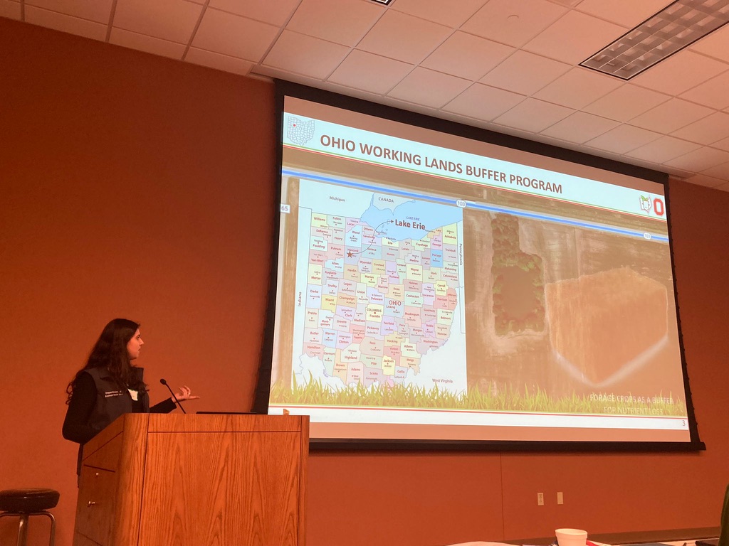
This project was conducted at two different locations in OH: south (Jackson, OH) and north (Jenera, OH). In south OH, pastures for grazing and hay were monitored at the Jackson Agricultural Research Station (OARDC/OSU). The Jackson station is a 334-acre pasture farm, managed with strip grazing, low stocking rate (0.8 cows/ha), and density (18,900 kg BW/ha; i.e. lenient grazing). Pastures are cultivated mainly with tall fescue, with the random occurrence of red clover, and orchard grass. Weeds are visibly present throughout the area. Pastures are fertilized with N-P-K and liming for pH control, which is common across the region. In certain areas of the farm, there has been recurring flooding since its establishment. Three treatments were identified for this scenario at the farm in 2019: flood and non-flood pastures for grazing and non-flood hayfield. In order to study the effects of flooding only on historically grazed fields (not associated with grazing), areas were fenced off and grazing excluded. In north OH, crops (such as corn and soybeans) are predominant. Flooding occurrence has been increasing, resulting in great nutrient loss to Lake Erie and eutrophication. Conversion to forage crops as a buffer for nutrients losses is encouraged through the Ohio Working Lands Buffer Program (WLBP), and farmers can harvest and remove forage for hay. This experiment was conducted at a commercial partnering farm in the Western Lake Erie Watershed region, Northwest OH. Corn-soybeans rotation was converted to forage crops under the program in 2019. Three different levels of flooded hayfields were considered as treatments: non-flooding, low-flooding, and high-flooding.
In both regions, three similar size plots were identified per treatment. Plots were considered pseudoreplicates (Hurlbert 1984). This study follows systems approach field research (Amini 2001; Drinkwater 2002; Azapagic 2003; Ploeg et al. 2006; Fiksel 2006), where the management practices monitored are not simulated. True replications were not possible, because treatment allocation could not be randomized. However, the advantage of this approach is the ability to capture the effects of the long-term history of recurring floods on soil and plant characteristics, that ultimately dictate GHG emissions, C and N contents, and forage quality. The alternative option (i.e. to simulate practices and flooding on a completely randomized area) would not have generated the same relationships between soil microbial community × soil physical and chemical conditions × GHG emissions × C and N contents × forage characteristics, nor provided satisfactory results to address the research questions posed in this study. To build a more detailed and specific conceptual model and be able to understand the underlying relationships between flooding, and soil, forage, and pasture characteristics, pseudoreplicates were the most appropriate option.
Soil texture (Bouyoucos 1951), density (Blake and Hartge 1986), total C and N (Brown 1998), and pH (Mulvaney 1996) were evaluated in 2021 and used to support the identification of plots (consistency among these characteristics was sought). In the fall of 2021 and 2022, soil samples were collected to determine permanganate oxidizable carbon, which represents the available pool of organic C (Weil et al. 2003; Culman et al. 2010) and soil protein (Hurisso, Culman, and Zhao 2018) that represents the available pool of organic N in the soil. The occurrence and intensity of the floods were monitored in both scenarios during 2021 and 2022. Squelchy noise flooding observations (Adapted from Rinderer et al. 2012) were made after every rain event in both locations. In each plot, a “zigzag walk” was taken (approximately 20-m-long with steps of 1-m-long) and 20 spots were monitored. In every step, soil was classified as: (1) not saturated at surface, totally dry; (2) saturated at surface and without visible water above surface (squelchy noise can be heard when stepping on the ground); or (3) saturated at surface and with visible water on soil surface. Flooding observation included the sum of spots scored as 2 and 3. When 5 or more flooding observations were present, pasture was considered flooded. In addition, water table depth was constantly monitored using groundwater wells in the plots.
Forage and GHG emissions were monitored during three sampling periods (spring, early summer, and late summer) of 2021 and 2022, in both locations. Initially, samples would be collected in summer only but in conversation with farmers, we were made aware that flooding occurrence in late spring is increasing. Therefore, a spring sampling was added. Forage was monitored for weed abundance and botanical composition, by using the dry-weight-rank method with quadrats randomly placed in each plot (Mannetje and Haydock 1963). Bare ground frequency was monitored with a nylon string transect and readings were taken every 2 m. Forage was cut at stubble height for determination of total forage dry matter production (DM), species participation on total forage DM, and forage quality parameters (crude protein, acid detergent fiber, neutral detergent fiber, lignin, and digestibility).
Soil emissions of the three main GHG were monitored (CO2, CH4, and N2O) using the static chamber methodology (De Klein and Harvey 2013). Five chambers were placed per plot between forage cuts. Emissions were monitored once daily, for 4-days during each sampling period (spring, early summer, and late summer). Sample collection started at least 24 h after chamber placement to allow soil microbial populations to stabilize and avoid over-estimation of emissions. Static chambers are composed of a base and a cap and sealed with a rubber strap. Samples were collected for 20- min (at 0, 5, 10, and 20 min). Gas was collected from the chamber headspace with plastic syringes. The syringe contents were transferred to pressurized 20 mL vials. Sample vials were analyzed by gas chromatography. Flux was calculated based on gas concentration determined by chromatography, atmospheric pressure, and chamber volume. Chamber volume was measured once the chamber ring was placed in the ground to account for field variability. Environmental conditions were recorded daily during the data collection period: atmospheric pressure, soil water content, soil temperature, and ambient temperature (Chiavegato et al. 2015). Soil moisture was measured using a portable hand-held probe. In addition, rainfall and meteorological data were gathered from the weather station located at the Jackson farm and historical data from Jenera, OH.
Analysis of variance was performed using the Mixed Procedure of SAS (SAS Institute Inc. 2013. SAS 9.4 Statements: Reference. Cary, NC: SAS Institute Inc.). LSMEANS statements were used to calculate means and comparisons. Since soil inundation was not simulated or controlled, mean comparisons were considered statistically different at P ≤ 0.10, allowing observation of trends of changes in the ecosystem over time. Forage response variables (DM, botanical composition, and quality parameters), treatment was considered a fixed effect, and plots were considered a random effect. Plots were considered the experimental unit (pseudoreplicates). Year (2021 and 2022) and trial (Spring, Early Summer, and Late Summer) were considered repeated measures (double repeated measure). A general linear mixed model was used, and the interactions between treatment (NI, LI, and HI), trial (Spring, Early Summer, and Late Summer), and year (2021 and 2022) were explored. For the GHG response variables (CO2, N2O, CH4, and N2O + CH4 in CO2eq), treatment was considered a fixed effect, and chamber nested within plot was considered a random effect. Plots were considered the experimental unit (pseudoreplicates). Year (2021 and 2022) and trial (Spring, Early Summer, and Late Summer) were considered repeated measures (double repeated measure). A general linear mixed model was used, and the interactions between treatment (NI, LI, and HI), trial (Spring, Early Summer, and Late Summer), and year (2021 and 2022) were explored. Soil temperature and ambient temperature were considered covariates.
The analyses of permanganate oxidizable carbon (PoxC) and soil protein were delayed, and results are not yet available. The batch samples from 2021 were sent to the Soil Fertility Laboratory, under Dr Steve Culman and I did receive the results. However, a couple of months later, Dr Culman left Ohio State University and the Lab stopped providing the analysis. In conversation with my advisor, student advisory committee, and other faculty, we assessed that there is high variability in POxC and soil protein results from different Labs. So, my advisor and I decided to re-send the 2021 samples, along with the 2022 samples, to the University of Missouri Soils Lab. These changes took time and I have not yet received the results from the Missouri Soils Lab.
Results of this study showed that soil bulk density was lower in 0-5 layers than in 5-10 layers in both locations, yet values did not suggest soil compaction. Overall, soil bulk density values were lower in soil prone to flooding in comparison to soil non-prone to flooding. Flooding soils are under anaerobic conditions that slow SOM decomposition and increase its accumulation. For this reason, soil bulk density is usually lower in wet soils, which is associated with great C storage. In Jenera, a tendency to have a higher bare ground frequency in high-flooding areas in comparison to non-flooding and low-flooding was found. In Jackson, a tendency to a higher bare ground frequency in hayfields in comparison to pastures was found. Comparing Jenera and Jackson, Jenera had a higher bare ground frequency in comparison to Jackson. Therefore, the area management (pasture vs. hay field) has a much more impact on the bare ground frequency than flooding propensity (flood vs. non-flood areas).
Recurring short-term flooding did not affect forage production in any of the locations, indicating that forage crops may be a good option for soils prone to flooding. Forage botanical composition was lightly affected only when inundation events were more intense, increasing dead material and weeds proportion. Flooding also negatively affected some of the forage quality parameters in the Jenera where flooding had higher occurrence and intensity. For high-flooding areas, lower CP and higher NDF were found, while ADF, digestibility, and lignin were not affected. These results suggest that recurring short-term soil inundations do not affect forage production, and forage quality is lightly affected only in highly inundated soils.
When soil water content during sampling period was high, CH4 emissions were higher and CO2 emission were lower in comparison to lower soil water content values. High soil water content decreases oxygen availability and generates anaerobic conditions. Aerobic organic matter decomposition has CO2 as a final product, while anaerobic organic matter decomposition has CH4 as a final product, although it is more complex and less favorable energetically. For this reason, a pattern of CH4 emissions and lower CO2 emissions during periods of higher soil water content and CH4 sinks and higher CO2 emissions during periods with low soil water content was found. At the same time, N2O fluxes were negative in sampling periods with high soil water content. Soil water content also drives N2O fluxes. Under anaerobic conditions, denitrification is predominantly complete, thus producing N2 rather than N2O. For this reason, N2O fluxes decreased when soil water content increased. However, in both studies, even when the CH4 sink was observed, N2O flux drove the emissions on a C-equivalent basis. CO2eq flux calculation that considered N2O and CH4 emissions from soils was primarily determined by N2O flux. The values of CH4 + N2O CO2eq indicate that the sink potential of CH4 is overshadowed and compensated by extremely high emissions of N2O. From a carbon footprint perspective, N2O drives GHG emissions and should be considered in mitigation strategies. Overall, recurring short-term flooding did not consistently increase GHG emissions in any location, rather a tendency to decrease emissions was observed in high-flooding areas in Jenera. At the same time, quality forage production was possible in both studies. Forage crops then represent a sustainable and productive option for areas prone to recurring short-term flooding.
The Ohio Working Lands Buffer Program supports forage crops as a buffer for nutrient losses to water in areas prone to flooding. The results of this study added a plus for the program benefits since soil GHG emissions did not increase and high yield and quality forage production was observed in these areas. The program then was proven successful to increase productivity of flood-prone areas in the Western Lake Erie Basin, without leading to increased GHG emissions.
I am currently working on two manuscripts publications to be submitted. I am also working on educational factsheets about flooding identification and the benefits of the WLBP.
Educational & Outreach Activities
Participation summary:
In December 2020, the research proposal was presented at the 2020 Horticulture and Crop Science Graduate Research Symposium at Ohio State University, titled “Effect of recurring, short-term flooding on soil, pasture and environmental characteristics of grazing and hay pasture”.
Miquilini, M., Chiavegato, M. (2020) Effect of Recurring, Short-Term Flooding on Soil, Pasture and Environmental Characteristics of Grazing and Hay Pasture. Horticulture and Crop Science Graduate Research Symposium, Ohio State University. (Online Presentation)
In November of 2021, the preliminary results from Jenera were presented at the 2021 ASA, CSSA, SSSA International Annual Meeting (Salt Lake City, UT). The abstract titled “Forage Quality and Greenhouse Gas Emissions from Flood-Prone Hay Fields” was presented as a voluntary oral presentation in the C06 Forage and Grazinglands session.
Miquilini, M., Ribeiro, R. H., & Chiavegato, M. (2021) Forage Quality and Greenhouse Gas Emissions from Flood-Prone Hay Fields. ASA, CSSA, SSSA International Annual Meeting, Salt Lake City, UT. (Oral Presentation)
In December 2021, I presented the project proposal and preliminary results to the OSU Animal Science department as a 40-minutes seminar. The seminar was titled: "Effects of recurring, short-term flooding on soil, pasture and environmental characteristics of grazing and hay pastures".
In February of 2022, I presented our preliminary results from Jenera at the 2022 Ohio Forage and Grasslands Council Conference in London, OH, as part of the Ohio State University Forage Research Update, for about 55 farmers and ranchers, plus 10 agricultural professionals and we received very positive feedback from them.
In March 2022, the research results were presented at the 2022 Horticulture and Crop Science Graduate Research Symposium at Ohio State University, titled “Perennial Forages are an Alternative to Reduce Nutrient Losses to Water in Flooded Pastures – What Happens to Nutrient Losses to Air?”. I was also awarded the "People's Choice Award" for the presentation.
Miquilini, M., Ribeiro, R. H., & Chiavegato, M. (2022) Perennial Forages are an Alternative to Reduce Nutrient Losses to Water in Flooded Pastures – What Happens to Nutrient Losses to Air? Horticulture and Crop Science Graduate Research Symposium, Ohio State University. (Online Presentation, People’s Choice Award)
In July 2022, preliminary results from Jackson were presented at the 2022 ASAS-CSAS Annual Meeting in Oklahoma City, OK. A comparison between grazed and Hay Fields was presented in a poster presentation titled: "Balance Between Productivity and Environmental Impacts of Grazed and Hay Fields", and a comparison between flooding grazed pastures and non-flooding grazed pastures was presented in an oral presentation titled: "Effects of Flooding on Grazed Pastures – Forage Quality, GHG Emissions, and C Stocks".
Miquilini, M., Ribeiro, R. H., & Chiavegato, M. (2022) Balance Between Productivity and Environmental Impacts of Grazed and Hay Fields. ASAS-CSAS Annual Meeting, Oklahoma City, OK. (e-Poster Presentation)
Miquilini, M., Ribeiro, R. H., & Chiavegato, M. (2022) Effects of Flooding on Grazed Pastures – Forage Quality, GHG Emissions, and C Stocks. ASAS-CSAS Annual Meeting, Oklahoma City, OK. (Oral Presentation)
In November 2022, preliminary results from both Jackson and Jenera were presented at the 2022 ASA, CSSA, SSSA International Annual Meeting in Baltimore, MD in principal component analysis. A poster titled: "Relationships Among Forage, Soil and GHG Emission on Forage Crops Under Flooding Conditions" was presented in the C06 Forage and Grazinglands session competition, and I was awarded first place in the Robert F. Barnes Poster Competition Award. In addition, the flooding measurements made in the project were presented in the poster titled: " Measuring Flooding in 20 Quick Steps", also in the C06 Forage and Grazinglands session.
Miquilini, M., Ribeiro, R. H., & Chiavegato, M. (2022) Relationships Among Forage, Soil and GHG Emission on Forage Crops Under Flooding Conditions. ASA, CSSA, SSSA International Annual Meeting, Baltimore, MD. (Poster Presentation, Robert F. Barnes Poster Competition Award)
Miquilini, M., Ribeiro, R. H., Lyon S. W., & Chiavegato, M. (2022) Measuring Flooding in 20 Quick Steps. ASA, CSSA, SSSA International Annual Meeting, Baltimore, MD. (Poster Presentation)
In December 2022, I presented my project and final results as a 40-min exit seminar to my advisory committee (Dr. Marília Chiavegato, Dr. Braden Campbell, Dr. David Barker, and Dr. Steven Lyon), to the OSU Animal Science department, and to the OSU Horticulture and Crop Science department. The seminar was titled: “Effects of Recurring, Short-Term Soil Inundation on Forage Quality and Soil GHG Emissions from Pastures and Hayfields”.
Currently, 3 peer-reviewed papers and 2 extension publications are being written with final results from the project.
Project Outcomes
The effects of recurring short-term flooding baseline support the decision-making on the management of these areas prone to flooding. The Ohio Working Lands Buffer Program's effectiveness was also highlighted. The program supports the establishment of forage crops to decrease nutrient losses to water in sensitive areas. In this project, we also found that nutrient losses to air (by greenhouse gas emissions) were not increased. In addition, we found good forage quality and production in these areas. The collaborating farmer reported previous crop yield losses in the fields prone to flooding, and after planting perennial forage crops, high hay yields were possible from the area. The information generated from the project is useful to ensure the success of the Ohio Working Lands Buffer Program, allowing water and air quality improvement. The success of this program may provide a basis for development of new/similar programs across the NCR. Outcomes improve the quality of life of farmers, consumers, and society.
During the course of this project, our awareness of increasing flooding in Ohio was reaffirmed. We were able to capture flooding occurrences several times going out in the fields throughout the years, not only on our experiment's plots but also on farms across the state. By traveling from one region to another, we could see a large number of crop fields being affected by recurring short-term flooding. It led to recognition of the critical need to study specifically recurring short-term flooding in the Midwest and ways to get sustainably yield from these areas. These results provided an important baseline for understanding the effects of flooding on pasture and soil characteristics and greenhouse gas emissions. With this information, we can start to propose forage and grazing management strategies that will allow for sustainable use of flood-prone areas. Currently, there are three additional funded projects that build upon the present project. The first one is studying warm-season grasses implementation protocols, relationships with arbuscular mycorrhizae and morphogenesis as a forage option for flooded areas. The second one is looking at different forage diversification strategies and innovative grazing management strategies to flooded pastures. The third one will evaluate GHG emissions from flooded and grazed pastures. All of these projects are based on, and were made possible due to, the baseline on flooding effects generated in this project.
We were also able to adapt a flooding method to monitor flooding. We measured flooding with two available methods: pressure transducers with groundwater wells (precise but expensive) and the “squelchy noise” (Rinderer et al. 2012; cheap, time-consuming, and subjective to bias). We were able to connect the two methods to estimate time under flooding throughout the years. In a scenario of increasing flooding occurrence, this methodology is an asset for future flooding research projects needed.
Hay farmer in North region in Ohio mentioned, in multiple occasions, that adherence to the WLBP was a great decision as he sees that perennial forages provide higher yields than the corn-soybeans rotations. He also was excited to hear that the conversion did not increase greenhouse gas emissions and felt that he is contributing to climate change mitigation.
Producers have mentioned many times they see frequent (and increasing) occurrences of flooding and noticed lower productivity in these areas. Grazers that heard the project's preliminary results at the Ohio Forage and Grasslands Council meeting were happy to know that this proejct will lead to further understanding of grazing management that will allow for productive and sustainable use of their flooded pastures. A few producers mentioned that if we identified sustainable grazing management that would make the WLBP allow grazing, they would also join the Program.
The project found that perennial forage crops established in the areas prone to recurring short-term flooding did not increase nutrient losses to air and also, provided forage yield to farmers. The next step will be understanding grazing effects in these scenarios.