Final report for GS21-249
Project Information
Grazing lands are essential for global food security and delivery of ecosystem services, and they represent a predominant land use in the southeastern United States, especially in Florida. The multi-functionality of these landscapes, as well as the spatiotemporal variability therein, create complex management problems, which are best solved adaptively and with a process-based understanding. Adaptive multi-paddock (AMP) grazing management has been shown to enhance economic returns for farmers, as well as the delivery of ecosystem services. Grazing land managers rely on frequent pasture monitoring to implement AMP systems, such as pasture regrowth periods, stocking densities, and livestock rotations. However, traditional tools for on-farm forage measurement – visual identification, rising plate meter, etc. – provide limited information and do not readily scale. By contrast, satellite-borne remote sensing platforms capture a broad spectrum of data over large extents and have been shown to provide near real-time estimates of pasture quantity and quality. Moreover, these estimates can be inserted into pasture productivity models and developed into a user-friendly format, providing forecast of pasture characteristics valuable to grazing land managers at a variety of scales. Therefore, the objectives of this study are (1) to assimilate high quality land surface data, including satellite imagery and weather models, into a pasture productivity model for the forecasting of pasture characteristics most useful to land managers (e.g., biomass, crude protein, digestibility) and (2) to evaluate the integration of this technology into AMP grazing systems.
The objectives of this study are:
- to assimilate high quality land surface data, including satellite imagery and weather models, into a pasture productivity model for the forecasting of pasture characteristics most useful to land managers (e.g., biomass, crude protein, digestibility)
- to evaluate the integration of this technology into AMP grazing systems.
Objective 1
The process-based pasture growth model will assimilate key pasture characteristics – biomass, LAI, foliar nitrogen content – estimated from Sentinel-2 data. The empirical models to estimate these variables are currently in development, in our large ground truthing experiment. Preliminary models from Landsat-8 imagery and gridded climate data show strong capability to predict out-of-sample biomass (R2 = 0.72) and crude protein (R2 = 0.88). The pasture growth model will require calibration of parameters specific to subtropical pasture, such as canopy light extinction, radiation use efficiency (RUE), and rate of senescence. To accomplish this calibration, a time series of pasture growth and development data will be developed, and values for each parameter will be empirically established. With all components in place, the model will be developed to receive near real-time updates of Sentinel-2 imagery and gridded climate data via the Google Earth Engine (GEE) cloud-computing platform. State variable outputs will be validated on experimental and operational pastures.
Objective 2
To evaluate the potential for integration of the developed model into a decision support framework for AMP management, a historical dataset of pasture growth on Deseret Cattle and Timber pastures will be developed using the pasture growth model and historical Sentinel-2 images. We will pair this dataset with a record of grazing management where available from each pasture, in collaboration with our partners at Deseret. From these datasets, we will retroactively forecast pasture production and evaluate the corresponding management decisions to determine if forage quantity and quality were optimally utilized based on our model.
Research
I. Objective 1
The study will take place at the Beef Research Unit in Gainesville, Florida, in fields managed by the University of Florida (UF) Agronomy department. The fields have been historically used as pasture and are currently predominantly Pensacola bahiagrass. The soil order is Spodosol with 0 to 2% slopes and moderately poor drainage. These characteristics are representative of a majority of Florida pasture. On-site weather variables are collected including precipitation, PAR, and temperature.
To deliver the RS-informed pasture productivity forecasting model, the following components are necessary:
- Empirical models estimating pasture physiological state variables (LAI, biomass, %N) from RS imagery
- Development of a process-based growth model appropriate to forecasting Florida pasture characteristics, followed by calibration of its parameters (canopy light extinction, RUE, and senescence) in a framework that can both generalize to regional pasture and capture critical site-site variations
- Assimilation of RS imagery into the growth model
- Validation of the model outputs
Component 1
In a funded collaboration with Deseret Cattle and Timber – the largest ranching outfit in Florida - we have already developed very promising preliminary models for estimating key pasture characteristics, and we are currently running a large ground truthing experiment to improve and validate these models. Thus, at the beginning of this SARE-funded project, component 1 will already be fulfilled or nearing completion.
Component 2
First, we have already developed a small suite of minimally complex growth models based on biophysical principles of light interception (driven by leaf area index, LAI), and production of pasture driven by light-use efficiency (LUE). Our model for LUE in turn can readily represent variations in pasture composition, as well as variability in weather (temperature, precipitation) and edaphic conditions. Moreover, through implicit representation of mean canopy age, and explicit representation of canopy N, our models are also well-suited to track critical parameters of pasture quality including crude protein, lignin levels and digestibility. To calibrate parameters of our LUE growth models based on empirical data, we will need to track pasture physiological development over time. This will be performed in ten small scale (2m x 2m) plots for the duration of the growing season (April-October). One plot will be manually clipped to 2-inch residual height each week in a 10-week rotation. This gradient design ensures the measurement of physiological development from an array of regrowth periods and for the range of climatic conditions typically exhibited in southeastern pasture subtropical pasture. The physiological measurements taken weekly in a subsample destructive harvest include forage biomass, LAI, light interception, nutritive evaluation (crude protein, %N, digestibility), and percentage of senescence.
At the end the growing season, we will have a time series of bahiagrass pasture physiological development from which key parameters for the process-based model will be calibrated using empirical statistical methods.
Component 3
Using the GEE cloud-computing platform, RS imagery and gridded climate data will be acquired in near-real time. From the empirical models, the RS imagery will be converted into gridded distributions of pasture characteristics, which are used as inputs of the process-based pasture productivity model. With the addition of the calibrated parameters of Component 2, all components are ready to validate the model performance and allow cloud updates for continuous model improvement.
Component 4
To validate model performance, pixel-sized pasture plots (20m x 20m) will be sampled for the state variables of interest (biomass, LAI, crude protein). Some of these plots will be located inside experimental paddocks at BRU. Additional plots will be located in the operational pastures of Deseret. The pasture productivity model should allow for accurate forecasting of pasture development in between satellite image acquisitions. Validating data will continue to be taken until a statistically significant number of plots has been reached. Simulated model outputs will be evaluated using goodness-of-fit assessments.
II. Objective 2
To evaluate the potential for integration of the developed model into a decision support framework for AMP management, a historical dataset of pasture growth on Deseret Cattle and Timber pastures will be developed using the pasture growth model and historical Sentinel-2 images. We will pair this dataset with a record of grazing management where available from each pasture, in collaboration with our partners at Deseret. From these datasets, we will retroactively forecast pasture production and evaluate the corresponding management decisions to determine if forage quantity and quality were optimally utilized based on our model.
Specifically, grazing rotations will be evaluated on regrowth period and stocking density for each management unit. For example, if livestock were rotated into paddock A, but our model reveals that this paddock had not yet achieved optimal levels of biomass and crude protein, then we can quantify the potential for forage production improvement. Furthermore, management units contain variation in production. We will evaluate the grazing rotation scheme of the ranch to determine if management units are being over- or under-utilized. Our evaluations will be guided by AMP principles to optimize forage quantity and quality. We will solicit feedback from Deseret on the utility and feasibility of the management recommendations. Findings will be shared with the scientific community through conferences and publications and with the producer community through extension events and further efforts to make the model publicly accessible.
Results and Discussion
Overall, over the course of this project significant progress was achieved towards the components of objective 1, while objective 2 proved more challenging and largely remains to be achieved. We published two peer-reviewed manuscripts, two conference proceedings, and delivered multiple conference presentations based entirely or substantially on data collected as part of this funded project. Moreover, we provided training opportunities for multiple graduate students in addition to the PI Hunter Smith, and multiple undergraduate assistants. Below we will summarize the scientific progress achieved on this grant toward objective 1 in two broad categories: estimating pasture characteristics from remote sensing and biophysical modeling.
Objective 1
Remote sensing: we achieved substantial progress toward all of the project objectives related to remote sensing of pasture, including forage biomass accumulation and forage tissue quality (e.g. %N). Our findings in this regard were published in the peer-reviewed journal Remote Sensing (Smith et al. 2023). Our experimental design was executed as planned, and successfully created a wide gradient in pasture characteristics to be captured by spectral models, based on satellite remote sensing data. Satellite data were collected from the Sentinel 2 platform using Google Earth Engine. After confirmation of a high-quality satellite image (e.g. free from cloud contamination), ground data were immediately collected via clipping and use of a digital rising plate meter with GPS-enabled capabilities.
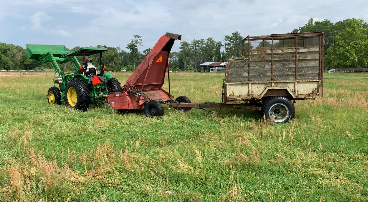
Figure 1: Forage harvesting at the Beef Research Unit (Gainesville, FL).
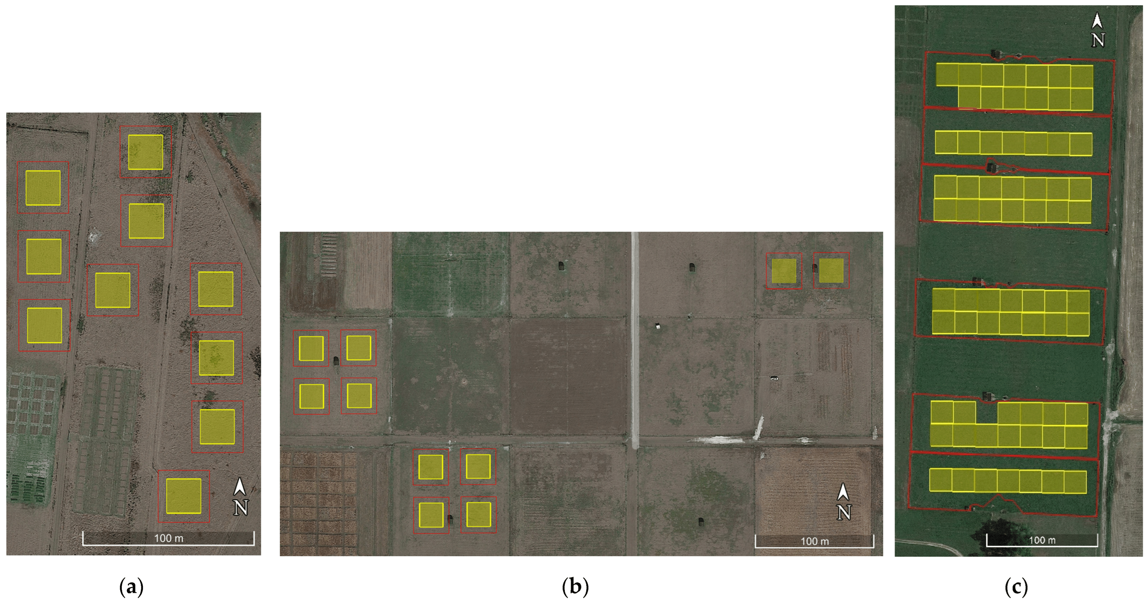
Figure 2: Experimental design for establishing a gradient of pasture canopy characteristics via offset defoliation. Of note, these squares were centered on Sentinel 2 pixels, including a 10m buffer. This research was conducted at the Beef Research Unit of the University of Florida in Gainesville, FL and this figure is reproduced from Smith et al. 2023a.
We then fit a suite of carefully selected machine and statistical learning algorithms to link measured characteristics (biomass, %N) to spectral data from the Sentinel 2 platform. This resulted in a variety of model fit characteristics depending on sampling date, as well as evaluation structure. Briefly, it is standard practice to quantify predictive accuracy on hold out data, separate from those used to train a model. But the selection of which data to hold out is non-trivial in many cases. Rather than hand-pick a single evaluation structure, and thus risk cherry picking an especially favorable looking evaluation metric, we systematically compared many methods of holding out data, ranging from less and more rigorous. Eventually, we even included data from two additional sites: the North Florida Research and Education Center (NFREC) of the University of Florida, and a pasture site from Deseret Cattle and Timber. The ultimate model test is to predict from one site to another. Overall, we found that many statistical and machine learning algorithms could perform reasonably well, but that simpler models held up better to increasing extrapolation challenge. Moreover, a major conclusion from our research is that satellite remote sensing should NOT be judged based on a single acquisition or site-year of data, but rather that carefully constructed evaluation tests that mimic the real-world application should be used for testing and refining remote sensing models.
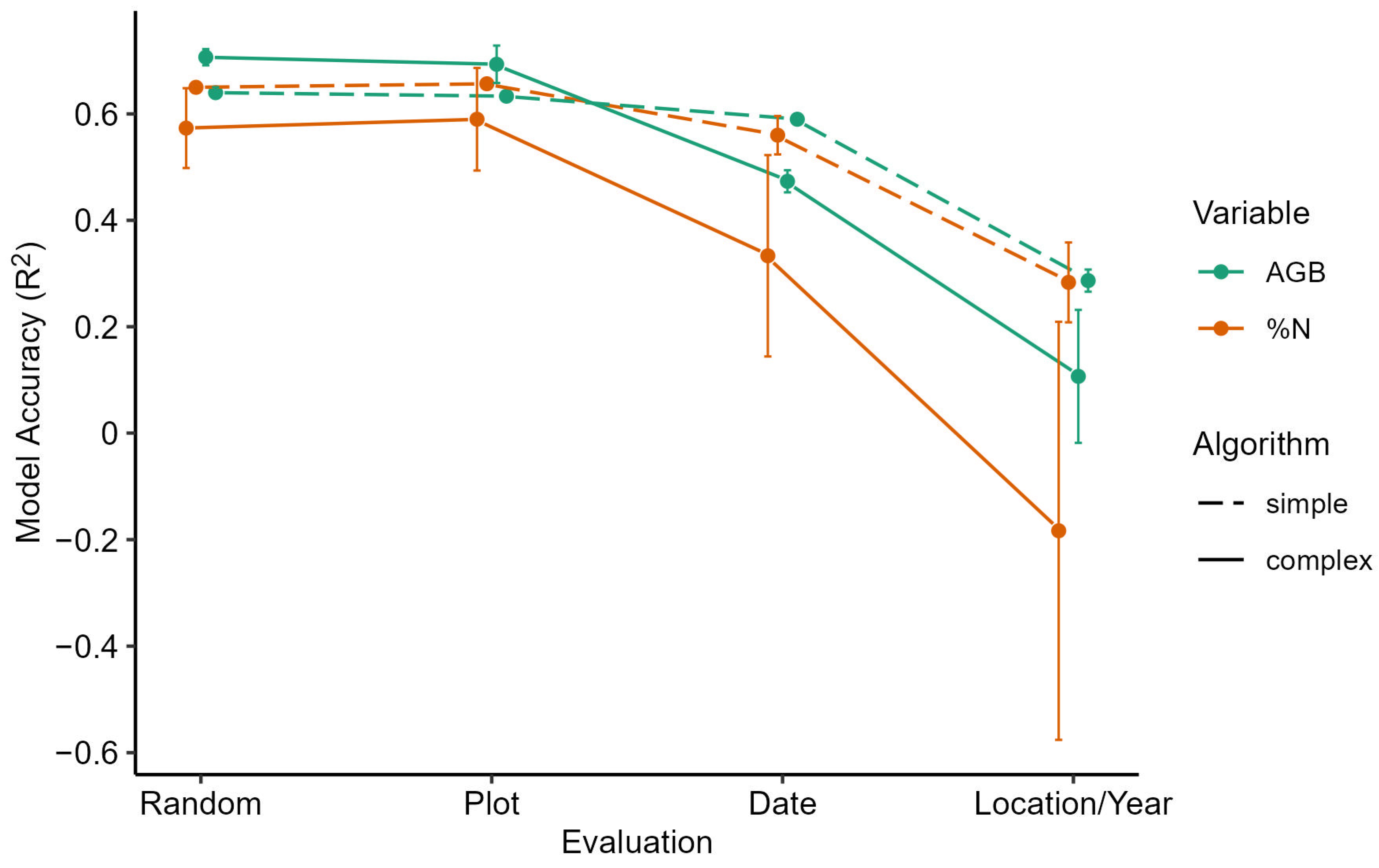
Figure 3: Summarized model performance based on algorithmic complexity and in order of increasing extrapolation challenge. All models suffer substantial declines in predictive fit when challenged to generalize across both site and season, but the more complex machine learning algorithsm (e.g. random forests) suffer the most. We recommend simpler models (e.g. LASSO) be used wherever possible. Figure reproduced from Smith et al. 2023a.
Biophysical modeling: substantial progress in biophysical modeling was made in two different directions. As per project goals, we have advanced our understanding of radiation-use efficiency (RUE) in bahiagrass, reporting our results to date in several conference talks and in one paper in the International Grassland Congress Proceedings of 2023 (Caram et al. 2023). To summarize, we find that RUE is strongly influenced by fertility, increasing with fertilizer applications up to twice the UF IFAS recommended rates without fully leveling off. However, the relationship with tissue %N is more nuanced (one of the targets of our remote sensing research), in some cases being positively associated, and in others negatively associated. We have not yet published these findings in a peer-reviewed journal, but anticipate doing so in the next year, and will be sharing our data at that point. Preliminary investigations of process-based models relying on leaf area index (LAI) and RUE to forecast production are very promising and have been presented several times – however the integration with satellite data is work that remains to be done.
The other major research was to adapt bahiagrass data into an updated module for the widely utilized DSSAT CROPGRO crop modeling platform. This research involved data from multiple experiments, dating back several decades, as well as contemporary data from project PI Wilson’s bahiagrass experiments. The progress on the DSSAT model was published in peer-reviewed journal Field Crops Research as Smith et al. 2023b. This research was vital to establish a linkage between our research objectives and a widely utilized crop modeling platform, providing a more secure foundation for future data assimilation activities.
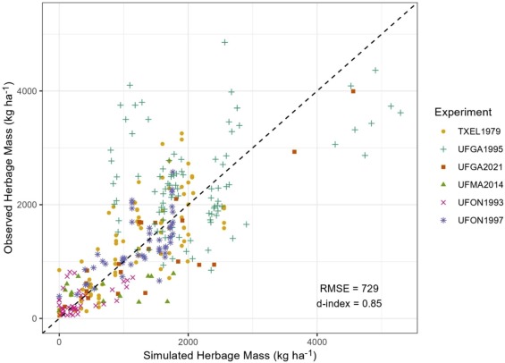
Figure 4: Observed versus predicted pasture biomass from 6 different experiments, using a newly calibrated version of the DSSAT CROPGRO model for bahiagrass. Figure reproduced from Smith et al. 2023b.
Objective 2
In addition to above, progress was made on a pasture mapping tool developed in Google Earth Engine, and shared privately with project collaborator Deseret Cattle and Timber. This tool takes one of the models from the remote sensing in objective 1, and maps out the predicted forage biomass. However, we were unable to collaborate on suitable management records at the time of this project to test integration into management-intensive or adaptive grazing protocols, nor were we able to directly link the satellite and biophysical models via data assimilation. In retrospect, these are both very challenging scientific goals. We believe our findings provide a robust foundation, but additional project funding and interdisciplinary collaborations will be vital to making substantial headway in those directions.
Peer Reviewed Manuscripts:
Smith HD, Wilson CH, Rymph SJ, Santos ER & Boote KJ (2023). Adapting the CROPGRO Perennial Forage model to predict growth and development of Pensacola bahiagrass. Field Crops Research, 302, 109095.
Smith HD, Dubeux JC, Zare A & Wilson CH (2023). Assessing Transferability of Remote Sensing Pasture Estimates Using Multiple Machine Learning Algorithms and Evaluation Structures. Remote Sensing, 15(11), p.2940.
Educational & Outreach Activities
Participation summary:
Conference Presentations
Wilson CH, Smith H, Smith S, Kucharski S, Caram N (2023). Forecasting subtropical pasture production under climate and management scenarios: insights from a hierarchical Bayesian implementation of a canopy process model. ASA, CSSA, SSSA International Annual Meeting.
Kucharski S, Smith S, Smith H, Rusch H, Wilson CH (2023). Impact of Drought Stress on Forage Grass Production and Nutrient Management. ASA, CSSA, SSSA International Annual Meeting.
Wilson CH, Smith H, Dubeux J, Smith S (2022). Forecasting pasture productivity and ecosystem services at scale: insights and challenges combining cross-scale datasets with a canopy process model using a hierarchical Bayesian approach. American Geophysical Union International Annual Meeting, Chicago (IL).
Smith HD, Wilson CH, Dubuex J, Zare A, & Stewart D (2021). Remote Sensing Estimates of Biomass and Nitrogen Content for Improved Modeling of Subtropical Pasture Productivity. Ecological Society of America Annual Meeting.
Wilson CH, Smith HD, Stewart D, Dubeux J, Zare A (2021). Forecasting pasture growth and quality from space: integration of multi-spectral satellite and ground data with a process-based model using a hierarchical Bayesian approach. American Geophysical Union International Annual Meeting, New Orleans (LA).
Undergraduate Research Training and Experience
Multiple University of Florida undergraduate students have been involved in carryingout the project activities. Through their participation, they gained valuable experience and training.
Project Outcomes
Our findings mostly inform on the biophysical challenges inherent to developing model-based approaches in "precision agriculture", from which improvements in social and environmental sustainability can be expected:
- Our finding that model and evaluation structure deeply impacts assessment of satellite model performance is a critical insight for all future work in "precision agriculture" that seeks to leverage spectral data to inform on agroecosystem management
- The integration of multiple data sources into biophysical models that can inform management remains an elusive goal. Our progress toward this is useful, but we believe our outcomes suggest the scope of what is truly required to fully accomplish this vision.
- Looking across our results, we can suggest a range of realistic prediction uncertainty from any modeling platform intended to inform agroecosystem management. In the case of bahiagrass forages, an RMSE around 750 kg/ha is to be expected. While further improvements can be anticipated, we suggest this range is likely to be the ballpark for prediction error for the foreseeable future. Therefore, all future work that seeks to use models to inform on management decisions should factor this in, and accept and embrace that small variations in forage availability are unlikely accurately to be forecast.
- We gained greater awareness of the challenge of interdisciplinary, on-farm research and the importance of fostering collaboration
- Graduate student PI Smith gained invaluable experience in experimental design, project design and management
- We developed improved understanding of how freely available satellite data can inform on ranch productivity and management, and the challenges in converting data and simple models into actionable insights