Final Report for GW12-064
Project Information
There is a marked lack of environmental assessment in land degradation mitigation and ecological restoration programs. Where evaluation does occur, the human dimension is typically underrepresented. Moreover, the process tends to be producer- (technical experts) rather than recipient- (stakeholders) focused, limiting local relevance and usefulness. The most common alternative involves inviting stakeholders to participate in a discussion of assessment results. This may capture their opinion, but not the context of land degradation mitigation contribution to the actual evaluation. Overcoming this challenge may be possible by engaging all stakeholders (including scientific experts) in the identification and prioritization of the criteria used to assess conditions, followed by an evaluation of impacts supported by the criteria they have selected and ranked. This project was focused on the development and testing of such a participatory evaluation protocol in the San Simon Watershed in southeastern Arizona.
Introduction
Human interventions to manage and/or restore degraded lands are common in drylands worldwide, e.g., Pinus halepensis afforestation projects in the Mediterranean (Bautista et al. 2010) or livestock management designed to conserve soils and the vegetation of grasslands in the southwestern U.S. (Roundy and Jordan 1988, Allen 1995). What is also common of past land management and restoration actions in drylands is the lack of systematic monitoring and evaluation after they have been implemented (Aronson et al. 1993; Rey Benayas et al. 2009; Bautista et al. 2009) and the poor consideration of perceptions and knowledge of local populations who impact or are impacted by the mitigation and restoration actions in question (Bautista et al. 2010;Whitfield and Reed 2012). An integrated and participatory post-assessment that includes top-down and bottom-up worldviews through the involvement of different stakeholders throughout the entire process is essential for better decision-making and definition of policies (McDuff 2010; Hisschemöller et al. 2001; Estrella and Gaventa 1998). Integration of local knowledge in environmental management and assessment processes can be useful to inform science priorities (Tribbia and Moser 2008, Rice et al. 2009, Alexander et al. 2011), identify knowledge gaps (Ewing et al. 2010), contextualize problems and the array of solutions on a local-based scale (Blackstock et al. 2007, Krueger et al. 2012) and avoid time lost and costly future conflicts related with misreading local realities (Sinclair et al. 2008). Participatory processes that engage stakeholders (scientists, practitioners, land users, etc.) all the way through the environmental assessment process increase the potential of ensuring what is measured is relevant to most, if not all, stakeholders. These processes are more than a transfer of results but provide an opportunity for mutual learning and the integration of scientific and local knowledge, where the evaluation both informs and empowers all participants.
The San Simon valley in southeastern Arizona was a key place to implement a participatory environmental assessment because it is one of the most dramatic examples in the southwest of extensive and severe erosion and also of intensive intervention. The San Simon valley is located in United States at the convergence of the Sonoran and Chihuahuan deserts of southeastern Arizona and southwestern New Mexico. The southern side of the drainage originates at 12 miles from the U.S. – Mexico border. The 2,250 square mile watershed is flanked on the east by the Chiricahua Mountains (highest peak in the valley 9,759 feet) and on the west by the Peloncillo Mountains (highest peak in the valley 4,990 feet). The valley takes its name from the ephemeral San Simon River that runs northwest and deposits its water in the Gila River. The Gila, which flows westward, joining the Colorado River near Yuma, is the primary source of water for one of the most important farming areas of Arizona. Over 41% percent of the San Simon valley is managed by the U.S. Department of Agriculture Bureau of Land Management (BLM), 26% is Arizona State Trust Land, 19% is private land and 13% is managed by the U.S. Department of Agriculture Forest Service. There is agriculture in some areas of the watershed (USDA & WRRC 2007), but the major land use, especially in the area of interest for this research, is grazing and recreation under the supervision of the BLM (ADWR 2010).
The earliest descriptions of the pre-cattle boom we have of the San Simon watershed are based on stories and anecdotes - sometimes very different from each other - from pioneers and explorers in the 1840s (e.g., Oscar Hutton, Lt. William H. Emory and John Russell Bartlett), soldiers from the California Column in 1862, stockmen in the 1880s and many others that crossed at some point or inhabited the San Simon valley before the 1890s. Even with these documented accounts of the whole watershed, it is not clear what the story might have been in a specific location or time of the year. This could account for the different descriptions found about this watershed. What is true is that the existence of some of those conditions attracted stockmen and farmers in the late 1880s and transformed this valley into a production-based landscape, especially for cattle raising (Jordan and Maynard 1970). By 1919 the San Simon had been transformed into a highly-eroded watershed needing extensive and immediate restoration (Olmstead 1919). It was after the Dustbowl and the Taylor Grazing Act of 1934 that the U.S. Grazing Service begun five decades of hydraulic control structures on the San Simon River and tributaries, followed by many other actions to combat land erosion, shrub encroachment and risk of flooding caused by the increase in bare soil and the arroyo-cutting. A first group of what were known as the “upstream measures” were initiated in the early 1940s and consisted of the implementation of large engineered structures like terraces and dams in the main channel and tributaries. There are now 19 major structures, including detention dams, several dikes and a large and still unknown number of relatively smaller earth structures. Other later phase interventions in the San Simon consisted of vegetation and livestock management methods aimed at recovering that grassland productivity. The existent grazing regimes are continuous, maintenance, intensive and custodial. On the vegetation management interventions, the common techniques are to remove shrubs and/or re-introduce species of grasses. To remove shrubs, the common techniques used are prescribed burning, mechanical removal by chaining (procedure where two crawler tractors drag an anchor chain to remove the shrub from the root) and chemical treatment with herbicides.
The land management and restoration actions that were evaluated in this study are located between the Cochise and Graham Counties jurisdictions, north of Interstate Highway 10 (I-10). Baseline information used in the study was collected following implementation of the IAPro protocol, which is founded on an ecosystems services framework and provides guiding methodologies that can be tailored to fit local conditions (Bautista and Orr 2011). Participants were contacted based on an initial list of key stakeholders suggested by a local Stakeholder Platform (Gila Watershed Partnership), the local University of Arizona Extension Agency Service and the Bureau of Land Management and following a chain referral procedure. Results from this study will be useful for land management organizations/entities that are interested in the translation of science for society based on a stakeholder-engagement form of participation in the assessment of environmental actions in the context of strategies to combat degradation and desertification in arid and semi-arid lands.
Objective | Performance and target date | Result | Date concluded |
Complete the assessment protocol, obtain IRB approval, and conduct preliminary tests | Oct - Dec 2011 | Preliminary protocol ready | May 1, 2013 |
Identify and engage a representative of stakeholders | ~25 stakeholders engaged (Jan - Mar 2012) | 35 stakeholders interviewed | May- Sept, 2013 |
Obtain a baseline assessment of the mitigation and restoration actions from each stakeholder | ~25 baseline assessments completed (Apr - Jun 2012) | 34 stakeholders provided baseline assessment and one only contextual interview. | July 2013 |
Elicit stakeholder-identified indicators of assessment and have them ranked | List of stakeholder identified & ranked indicators (Jun- Aug 2012) | List of ten assessment indicator/criteria suggested and ranked by 33 of the 35 initial stakeholders. | September 2013 |
Incorporate changes in perspectives through exchange of perspectives on the indicators | Final individual and group rankings obtained (Sep 2012) | Perspectives on indicator were collected in step 3.a and later re-evaluated in 3.b. to obtain exchange of perspectives. | September 2013 (3.a) and November 2013 (3.b.) |
Obtain (secondary) or collect (primary) data for indicators for each action | Data sets assembled (Oct 2012 - Feb 2013) | Primary biophysical information and remote sensing information for seven indicators and three expert-based evaluations for each action obtained. | Collected during June-September 2012 and July-August 2013. |
Facilitate reassessment of the mitigation and restoration actions after the monitoring data on the selected and ranked indicators are applied | ~25 reassessments completed for individual and group (Mar-Apr 2013) | 12 reassessments completed. Rest of the participants could not participate of the final group meeting. | November 15, 2013 |
Refine protocol for potential application beyond San Simon watershed. | Final protocol completed (May-Jun 2013) | The protocol was refined previous the application in the San Simon with a smaller group of stakeholder group participating in a Master Watershed Steward class. The testing of the protocol was also important for the refinement of the larger | February 2012 |
Produce "Guide of Good Practices" to increase public engagement in support of sustainable protection and restoration measures in drylands. | Guide completed (Apr 2013). | The San Simon protocol itself is the guide of good practices for participation in environmental assessment. Since this team also contributed with what we learned to the larger international PRACTICE team, a set of articles and guidelines using the San Simon success story along with other applications worldwide is in progress and will be available online. | February 2014 |
Cooperators
Research
After gathering historic and contextual information and digitizing analog maps of past land management and restoration actions, it became clear that the San Simon watershed has undergone numerous and often overlapping human interventions. Information found about past management actions in the San Simon watershed was digitized using ArcGIS v. 10.0 (ESRI, Redlands, CA, USA). A team of experts (land managers working in the watershed since the 1970s, an ecohydrologist currently working in the watershed and three researchers (two range ecologists and another ecohydrologist)) independent to this study were consulted in an effort to categorize the actions in a meaningful way for the science and easy to understand from the perspective stakeholders. This resulted in into five actions that were found to coincide in location (four land management actions and one structures): 1) rotational grazing (ROT_GZ), 2) rotational grazing combined with all or some of the mentioned vegetation management techniques like reseeding or shrub control (ROT_GZ_VG), 3) long-term resting from grazing or allotments where grazing has been restricted for a period of 20 years (REST_GZ), 4) long-term resting from grazing combined with vegetation management methods (REST_GZ_VG), and 5) hydraulic structures such as dams and dikes (STRUC).
Participants in this study were contacted based on an initial list of key stakeholders suggested by a local Stakeholder Platform (Gila Watershed Partnership), the local University of Arizona Extension Agency Service and the Bureau of Land Management. Using the chain referral methodology (Bernard 2006) each stakeholder was contacted, invited to participate and asked to referrer other stakeholders. This research was approved by the Institutional Review Board for the Protection of Human Subjects (IRB project number: project number 13-0297; FWA number: FWA00004218).
Baseline information used in the study was collected following implementation of the IAPro protocol, which is founded on an ecosystems services framework and provides guiding methodologies that can be tailored to fit local conditions (Bautista and Orr 2011). IAPro has seven steps: identification and engagement of the site-specific stakeholder platform (Step 1), baseline stakeholder assessment on the actions (Step 2), stakeholder assessment of the relative importance of the various assessment criteria (Step 3), data collection for the assessment criteria (Step 4), integration of data and relative importance of the assessment criteria (Step 5), collective re-assessment of the actions (Step 6) and dissemination of results and best practices (Step 7). Some of the modules are fully participatory activities (Steps 1 to 3 and 6-7), while Steps 4 and 5 represent scientific and technical work to be performed by the local assessment team.
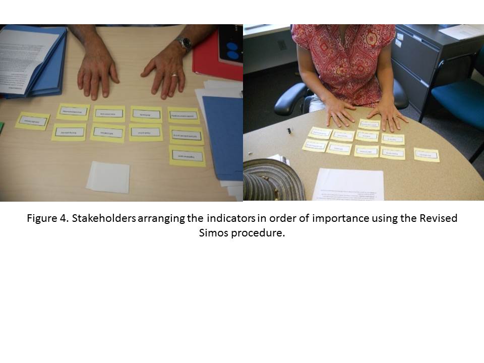
Through a semi-structured questionnaire with open-ended questions (60-90 minutes), (Step 2 of IAPro) stakeholders provided a baseline evaluation of each identified land management and restoration action and initial information on the context of the evaluation. The suggested positive and negative outcomes of each action provided also during the semi-structured interview (Step 2) were transformed to assessment criteria and prioritized using the revised Simos’ procedure for elicitation of weights (Step 3). The revised Simos’ procedure (Figueira and Roy 2002) is a method that uses a ‘card playing’ format in which different criteria are arranged in different levels (also called subsets), followed by the ranking of the subsets, with varying distance (blank cards) between subsets according to the difference in the relative importance according to the stakeholder. Performance of each criterion on each action was measured on either the ground or through remote sensing, or when empirical methods were not feasible, assessed by expert-judgment. Criteria weights and data for each criterion were integrated through the outranking multi-criteria decision aiding method and software ELECTRE IS (Roy and Skalka 1984; Aït Younes et al. 2000).
Final results were presented back to the stakeholders for group discussion and individual re-assessment of actions and prioritization of assessment criteria. A post-group assessment survey was filled by the participants after several interactive activities (see agenda) that provided the opportunity to share thoughts and preferences among participants and evaluate the whole process.
1. Assembled the project team. PIs Ocampo and Orr formed a project team to help with the interviews and the field measurements. This included the participation of one PhD student who collaborated with the interviews and one PhD, one Master student and one undergraduate who helped with the biophysical measurements. They all have taken and passed the CITI Social & Behavioral Research Investigators ethics in human subjects research training and obtained official certification. These project collaborators have experience in participatory processes, remote sensing analysis and/or biophysical monitoring. The team also includes the Graham County Cooperative Extension Director, Bill Brandau, who has been invaluable in helping organize field logistics and identifying stakeholders. An indirect member of the team is Jan Holder, the Director of the Gila Watershed Partnership, a key multi-stakeholder platform participant in the evaluation process.
2. Identified the land management actions to be evaluated by stakeholders. Based on the analysis of the information obtained in several field visits and review of 1940-2010 project files from the Bureau of Land Management Archive in Safford, Arizona, five groups of land degradation management actions were identified: a) structures near and in the channel, b) rotational grazing with vegetation management, c) rotational grazing without vegetation management, d) long term resting from grazing with vegetation management, and e) long-term resting from grazing without vegetation management.
3. Selected and mapped representative sites for each management action. An iterative process involving input from experienced land managers in the watershed and two watershed research scientists familiar with the climate, soils, vegetation and geomorphology represented by the San Simon watershed resulted in three representative sites for each action distributed in the watershed. Biophysical information was collected in each of these three sites.
4. Project approval by the IRB Human Subjects Board: Completed and approved all instruments, data collection/data entry forms and guidelines for stakeholder engagement activities and University of Arizona IRB Human Subjects approval FWA 00004218 obtained in 05/1/2013:
- Consent Form
- PRACTICE factsheet
- San Simon Actions factsheet
- Potential-Stakeholder Discussion Guide (Steps 1 and 2)
- Integrating and Weighting General and Site-specific Indicators (Step 3)
- Integrating data and perspectives (Step 5)
- Discussion Guide and Interviewer Outline (Step 6)
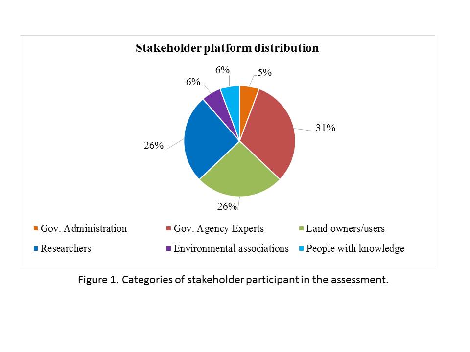
5. Stakeholder platform identified and engaged: Thirty-five stakeholders were contacted and interviewed (37% governmental agency experts, 6% governmental administration, 5% environmental associations, 26% researchers and 26% land users) on two occasions (May – September 2013).
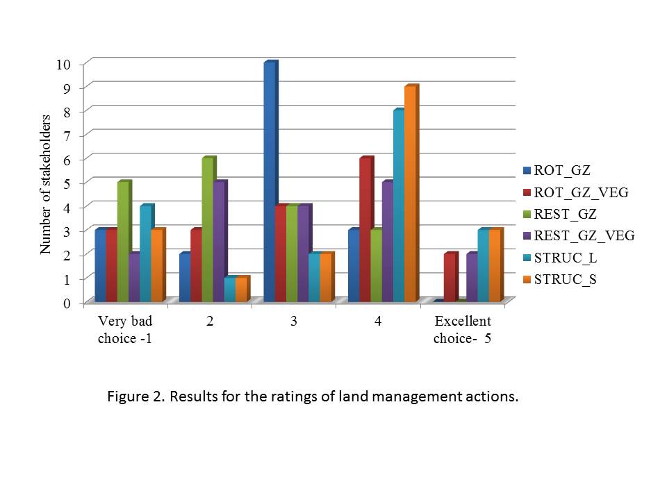
6. Baseline assessment of the mitigation and restoration actions obtained from each stakeholder: The 35 stakeholders’ platform evaluated the five actions in a Likert-type of question from 1 (very bad choice) to 5 (excellent choice). The structures were differentiated by some stakeholders as large in the main channel (STRUC_L) and smaller in the uplands (STRUC_S). The other actions evaluated were: rotational grazing without (ROT_GZ) and with vegetation management (ROT_GZ_VG) and long-term resting from grazing without (REST_GZ) and with vegetation management (REST_GZ_VG). Results showed divided opinions on the effectiveness of each of the five actions. Thirty-eight percent of them did not rate some or all of the actions due to the many factors playing a role in the results or were in consideration of their view that some of the actions were not so much land management and restoration actions but “political decisions.” Results for 63% of the participants that rated all the actions indicate that the small structures (STRUC_S), followed by (ROT_GZ_VEG) received slightly higher ratings (5 and 4) across the whole stakeholders group. Eighty percent of land users rated ROT_GZ in the medium of the scale (rate 3). More researchers (60%) rated with a four the actions REST_GZ_VG and STRUC. Practitioners (agency experts) gave a higher rate to the smaller structures (rate 4), while they had more divided opinions in the rest of actions. REST_GZ received lower average rates (1 and 2) among the stakeholders.
Stakeholders also provided valuable comments about the different techniques used in each of the actions, such as herbicide application, burning, chaining, cement structures, earth dikes, etc. They also commented on the potential use of this watershed as grazing rangeland or for wildlife conservation and how they perceive the climatic changes will affect the effectiveness of the different actions applied in the past and currently to increase herbaceous cover in the watershed. Here some of the comments gathered during the interviews:
- “Vegetation management does something, but dependent on climate. Can be too expensive and hard on the landscape.”
- “You have to rest and apply restoration efforts. But we need more time to see the results.”
- “Vegetation management is a mix of results, because depends on soil and location.”
- “Vegetation management is very positive, but needs more management, investment and people.”
- “Most of these interventions don’t end well.”
- “Most of them just transitional steps and too expensive. All can have good results if the conditions are good (rainfall and if not have crossed a threshold).”
- “Have not seen successful ones, worsen the abundance and diversity of vegetation.”
- “Vegetation management in the San Simon does not work. But long lived woody species need to be removed. Shrubs do not go on their own.”
- “Vegetation management methods are all useful. Not doing vegetation management is a very bad choice for this area.”
- “Large structures: some are good, some are bad. Each case is unique, cannot compare structure because have different objectives.”
- “Structures need a combination with other actions such as vegetation management.”
- “Structures are more a problem due to their maintenance cost.”
- “Structures are a big investment that also requires land management actions. Necessary to check the critical ones to restore or assist.”
- “Structures only have a localized effect and not for a long term. You need both structures and grasses to restore the soil. Nothing stops the water or help infiltrations if there is bare land.”
- Structures: “Would rather have them than not.”
- “Never seems to work long-term in any of the places I have seen them. They need more money and not enough money in the U.S. to fix the San Simon. "
- “I would advocate for structures just because of potential to keep the soil and regrowth shrubs.”
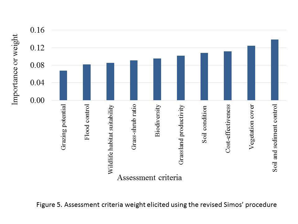
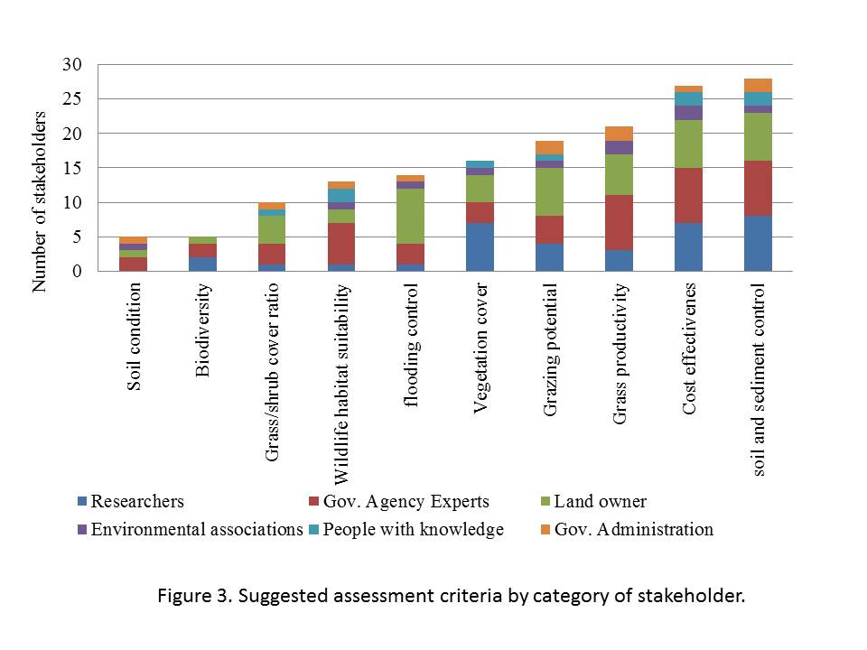
7. Stakeholder-based assessment criteria: The stakeholders interviewed suggested outcomes and conditions that were important to consider when evaluating the land management and restoration actions implemented in the San Simon Watershed. This list of suggestions was consolidated in a list of the ten most mentioned criteria/indicators: Soil condition, biodiversity, grass/shrub ratio, wildlife habitat suitability, flooding control, vegetation cover, grazing potential, grassland productivity, cost-effectiveness and soil and sediment control.
Table 1. Consolidated list of assessment criteria assembled by the 35 stakeholders participating in the San Simon watershed assessment. Each criteria belongs to a good or service from the Millennium Ecosystem Assessment (2005).
BIODIVERSITY | REGULATING AND SUPPORTING | PROVISIONING SERVICES | CULTURAL | ECONOMY | |||||
Wildlife habitat suitability | Biodiversity | Soil condition | soil and sediment control | flooding control | Vegetation cover | Grass productivity | Grass/shrub cover ratio | Grazing potential/ use (in the short-term) | Cost effectiveness |
Increase the presence of resources, conditions and to support occupancy of wildlife. | Variety and quantity of different types of plants and animals present in the area. | The chemical and physical condition of the soil that makes it healthy. | Reduction or halt the amount of soil that is being excessively eroded and transported away from a landscape via water or wind and accumulated somewhere else. | Reduction of the risk of flooding downstream when an extreme rainfall event. | Portion of land area that is covered vegetation of any type (e.g., shrubs, grasses, forbs, succulents) when viewed from above. | This refers to the rate of generation of grass biomass over time. | The relative area covered by grass versus shrubs. More grasses than shrubs is the desired condition. | Level at which the action promotes the possibility of grazing. This is not related with a possibility to increase livestock rate, since the number is fixed by BLM regulation. | A form of economic analysis that compares the relative costs and outcomes (effects) of two or more courses of action (fixed or initial costs as well as operating or maintenance costs). |
8. Prioritization of assessment criteria: Indicators ranked by 31 stakeholders using the Revised Simos procedure or “Pack of cards.” Each stakeholder evaluated the final consolidated list of suggested assessment criteria and prioritized it according to their own perspectives, using the methodology Revised Simos procedure. Average result showed more importance for the indicator ‘soil and sediment control’ and the less importance for ‘grazing potential’.
9. Conducted field measurements. Two biophysical measurement campaigns during July – September 2012 and July- August 2013 were necessary to collect information for selected common indicators (indicators that correspond to the Millennium Ecosystem Assessment) and indicators suggested by the stakeholders during the interviews: a) soil total carbon content (soil analysis), b) water and soil conservation (method Landscape Function Analysis (Tongway and Hindley 2004)), c) biodiversity of vascular plants (point intercept method), and d) wildlife habitat suitability (Normalized Difference Vegetation Index measured by remote sensing). For this work the team designed a set of protocols/guidelines and maps. Information was used to estimate an average value for each action in seven of the 10 suggested indicators.
10. Expert-based estimation of qualitative indicators/criteria: Questionnaires with Likert-type of question from 1 (not very effective) to 5 (very effective) were answered by two researchers in range management, one researcher in watershed hydrology and two practitioners with more than 20 years of experience in the San Simon Watershed. Information was used to estimate an average value for three of the suggested indicators for the five actions. The final assessment matrix with the average value for each suggested criteria/indicator on each action is presented in table 2:
Table 2. Assessment matrix with the criteria and data for each of the five land management and restoration actions used in the outranking assessment.
Assessment Criteria | Wildlife habitat suitability | Plant diversity | Vegetation cover | Grass productivity/abundance | Grass/shrub ratio | Grazing potential | Cost effectiveness | Soil and Sediment control | Flooding control | Soil condition |
Metric/ Proxy | Average accumulative NDVI | Shannon indexes | Landscape organization indexes (LFA) | Grass cover % | proportion grass/ | Expert-based estimation | Expert-based estimation | Stability indexes (LFA) | Expert-based estimation | Total Organic Carbon% |
ACTIONS (data) | ||||||||||
ROT_GZ | 4.00 | 0.50 | 0.14 | 7.33 | 0.50 | 2.50 | 3.83 | 49.50 | 2.00 | 0.27 |
ROT_GZ_VG | 4.99 | 0.58 | 0.48 | 18.33 | 8.85 | 3.17 | 2.83 | 51.17 | 3.00 | 0.32 |
REST_GZ | 4.10 | 0.28 | 0.11 | 1.07 | 0.05 | 2.33 | 3.33 | 44.60 | 4.00 | 0.22 |
REST_GZ_VG | 4.27 | 0.39 | 0.12 | 7.00 | 0.72 | 2.50 | 2.17 | 40.10 | 4.00 | 0.23 |
STRUC | 4.62 | 0.64 | 0.17 | 16.19 | 0.49 | 3.50 | 2.33 | 35.96 | 5.00 | 0.68 |
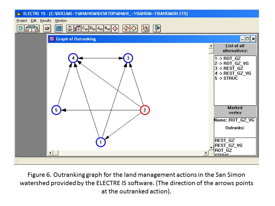
11. Integrated multi-criteria evaluation of actions: The outranking assessment integrating the assessment criteria, average criteria weights and average performance for each action indicates that ROT_GZ_VG is the action that outranks the rest (see circle 2 in figure 6). The ELECTRE IS integration result is a graph where each action that is better to another in respect to a threshold (concordance level) is represented by a pointing arrow in the direction of the worst action or the outranked action. Results in this case show that ROT_GZ_VG is not only superior on more criteria but also in those with higher average weight, which gives it an advantage over the other actions (represented by only outgoing arrows). In this analysis ROT_GZ_VG outranks the other four land management and restoration actions and no actions outranks back (as shown by the direction of the arrows in Figure 6). In the case of REST_GZ and REST_GZ_VG, both actions outrank each other as shown by the two-way arrow.
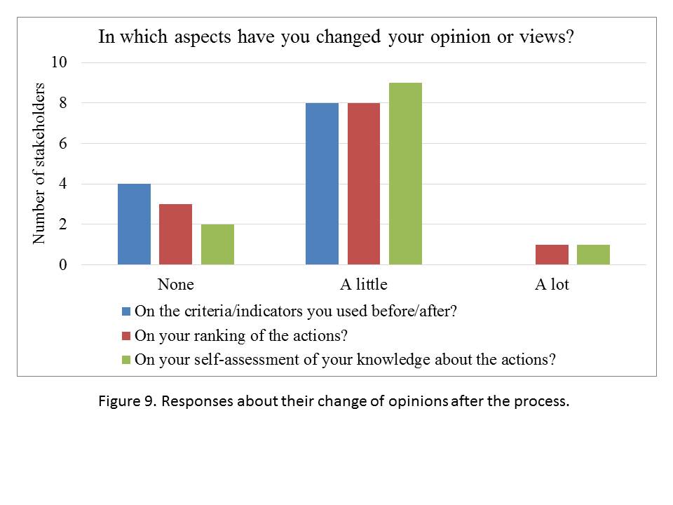
12. Re-evaluation of actions after integrated assessment: Twelve stakeholders participated of a group re-assessment of the actions and rank of assessment criteria. After each result presentation and several interactive activities in which stakeholders had the opportunity to share idea and perceptions, they were asked to run the revised Simos procedure again to prioritize assessment criteria, rate each action (from 1 to 5) and rank all the actions at once in order of their effectiveness to heal the San Simon Watershed. Results showed a change in perspectives after the group evaluation. Half of the participants reduced their extreme preferences between their most and the least important criteria. A smaller group of them increased the gap between the most important criteria for them and what they consider not important in this watershed in a way to stress their views (usually about grazing potential in this watershed). Evaluation of actions also showed a change in their original evaluations and more consensus in the usefulness of certain actions (Table 3), or what can be seen in some cases, as a tactic to focus the support to the action that they consider more important.
Table 3. Ranking of actions during the initial interview and after the group re-assessment.
Actions | Best action | Second best | Third best action | Fourth best | Last action |
| % of stakeholders | ||||
ROT_GZ_initial | 19 | 38 | 15 | 15 | 23 |
ROT_GZ_VEG_initial | 38 | 23 | 19 | 31 | 0 |
REST_GZ_initial | 15 | 35 | 35 | 23 | 4 |
REST_GZ_VEG_initial | 27 | 35 | 23 | 27 | 0 |
STRUC_initial | 27 | 31 | 38 | 8 | 8 |
ROT_GZ_after | 17 | 58 | 17 | 0 | 8 |
ROT_GZ_VEG_after | 42 | 33 | 8 | 8 | 8 |
REST_GZ_after | 17 | 0 | 42 | 8 | 33 |
REST_GZ_VEG_after | 50 | 8 | 8 | 33 | 0 |
STRUC_after | 25 | 8 | 33 | 17 | 17 |
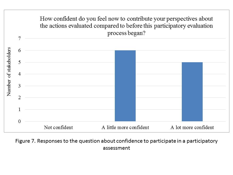
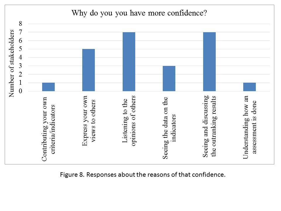
13.Final questionnaire: A post-process survey revealed that 42% of the stakeholders felt a lot more confident in sharing their views with other stakeholders after having participated in the participatory process. The rest of the 12 participants in the re-assessment mentioned being more confident. Stakeholders found that that the overall multi-criteria method was easily understood when explained in simple terms, using examples and stressing how their provided inputs were used in the integration. Over half of these stakeholders (58%) mentioned having more confidence to contribute with their perspectives in a future assessment and/or future planning efforts after seeing and discussing the outranking results of the five land management actions. After the presentation on the method and the outranking assessment results, 83% of the stakeholders also mentioned feeling that their views had been integrated in the assessment. Below some of the answers to the post-survey questionnaire:
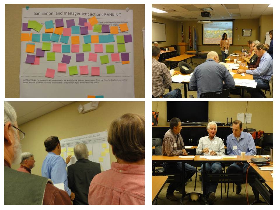
- Photo 1. Stakeholders arranging the indicators in order of importance using the Revised Simos procedure
- Figure 4. Revised Simos procedure
- Figure 5. Criteria weight elicited
- Figure 9. Responses about their change of opinions after the process
- Invitation to participate
- Figure 2. Results for the ratings of land management actions
- Figure 3. Suggested assessment criteria by category of stakeholder
- Photo 2. Final presentation of participatory evaluation results
- Figure 7. Responses to the question about confidence to participate in a participatory assessment
- Invitation final meeting
- Agenda final meeting
- Actions factsheet
- Figure 1. Categories of stakeholder participant in the assessment.
- Figure 6. Outranking graph for the land management actions
- Figure 8. Responses about the reasons of that confidence
Research outcomes
Education and Outreach
Participation summary:
Publications (in progress):
Ocampo-Melgar, A., Orr, B.J. and Brandau, W. Narratives and knowledge integration in participatory integrated post-assessment of land management actions: A case study from the San Simon watershed, Arizona. (in preparation).
Ocampo-Melgar, A. Orr, B.J. Participation and criteria selection: finding conflictive positions in environmental post-assessment of land management and restoration actions (in preparation).
Ocampo-Melgar, A. Orr, B.J., Baustista. S. Participatory outranking multi-criteria assessment of past land management actions in the San Simon watershed, Arizona (in preparation).
Posters and oral presentations:
Ocampo-Melgar, A., Jones, S.A. and Orr, B.J. 2013. Connecting Knowledge for Integrated Assessment of Land Management Actions in the San Simon Watershed. Research Insights in Semiarid Ecosystems. October 12, 2013, Tucson, Arizona, U.S.A. (http://www.tucson.ars.ag.gov/rise/Posters/Ocampo-MelgarPoster.pdf). Poster presentation.
Ocampo-Melgar, A and Orr, B.J. 2013. Enhancing the Potential for Sustainability through Participatory Environmental Assessment. Monthly meeting of the Gila Watershed Partnership. (http://gilawatershedpartnership.com/yahoo_site_admin/assets/docs/March_2013.13363409.pdf), Safford, Arizona. U.S.A. Oral communication.
Orr, B., A. Ocampo-Melgar, D. Garcia, T. Jones, M. Nichols, S. Marsh, M. Crimmins, C. Hutchinson. 2013. San Simon Watershed Assessment Project Status Workshop, February 2013. Tucson: Office of Arid Lands Studies, University of Arizona.
Jones, T., D. Garcia, A. Ocampo-Melgar, W. Brandau, and B. Orr. 2012. San Simon watershed (AZ, USA): Land Degradation and Mitigation Actions. Online: http://practice-netweb.eu/node/712
Ocampo-Melgar, A., 2011. Annual University of Arizona GIDP Poster contest.2011. (https://www.facebook.com/photo.php?fbid=281180618614523&set=pb.265816443484274.-2207520000.1355924916&type=3&theater).
Educational materials and social media:
As the formative process proceeded over the last two years, we refined and tested the participatory protocol to engage stakeholders in the evaluation of past land management and restoration actions. This very detailed protocol and all of the data and information collected during the participatory assessment are educational material for those interested in both the San Simon watershed and the goal of engaging a diverse group of stakeholders/evaluators in an environmental assessment. The outcomes and lessons learned of the participatory environmental assessment have been documented in a Google Site that has evolved over the project period. The first major iteration for this was an internal Google Site (not made public to ensure compliance with the IRB – though no personal information is included, it was still considered part of the larger research project while the research was being conducted). This site is entitled San Simon Watershed Project Intranet (https://sites.google.com/site/sansimonresearch/). The second site, which was completed in February 2014, will be transferred to the Gila Watershed Partnership. It is entitled “Participatory Assessment of the San Simon Watershed (Arizona)” (https://sites.google.com/site/sansimonassessment/). In addition, our work was endorsed by the PRACTICE NetWeb, and we received permission to participate on their website, along with initiatives in 11 other countries. This is a larger network of scientists and local users (PRACTICE NetWeb http://www.ceam.es/practice) interested in evaluating their own land management actions. We contributed to the design of the PRACTICE NetWeb and introduced the concept of making it a place where stakeholders could share success stories and good practices. In 2013, the PRACTICE NetWeb was one of eight knowledge management systems selected by the Secretariat of the UN Convention to Combat Desertification in their effort to develop of “portal of portals,” known as the Scientific Knowledge Brokering Portal (SKBP),
These Google Sites, and ultimately the SKBP, will facilitate content contribution, sharing and co-management among stakeholders that participated in the project and a new interested audience. Through videos, comments and stories, we expect to share this experience with local stakeholders in the San Simon, and ultimately, the larger international group of people concerned about decision making to combat desertification.
We also promoted the work of the P.I. Mary Nichols at the Southwest Watershed Research Center that took charge the Giga pan initiative (http://www.gigapan.org/), using as example the San Simon watershed. Our research was shared as part of meeting with the BLM District office in order to look for future possibilities of collaboration and useful uses of this technology. We expect to keep collaborating with this initiative in the future. To learn more about this initiative, see: http://repository.cmu.edu/cgi/viewcontent.cgi?article=1023&context=gigapixel.