Final report for SW22-937
Project Information
Changing climate, development, and the need for habitat protection is increasing pressure on US farmland. Climate-related changes in precipitation and drainage challenges are leading to areas of formerly productive agricultural lands becoming increasingly saturated, and regulations restrict the addition of new drainage. Meanwhile, the decreasing availability and rising cost of agricultural land is driving new farmers to purchase marginal land that often suffers from hydrologic issues. These factors especially impact socially and economically disadvantaged farmers, limiting their access to well-drained land.
Farming seasonally wet fields presents problems for annual crops and can have negative impacts on nearby water quality, but farmers must maximize land resources to remain economically viable. This makes it difficult to set aside land for conservation or restoration without sufficient financial incentives, yet existing incentive payments are often not large enough to offset production losses.
“Working buffers”–a perennial agroforestry cropping system that can be used on seasonally wet farmland–are a promising approach for farmers to both protect water and soil resources and generate income on marginal areas. To increase working buffer adoption, more research is needed to understand their economic feasibility and their effects on water quality and soil health in the Pacific Northwest.
This proposal is for Snohomish Conservation District (SCD), Skagit Conservation District (Skagit CD), Whidbey Island Conservation District (WICD), Snohomish County, and Washington State University (WSU) Extension to study the water quality effects of working buffers and conduct outreach to producers and agency staff. Our SARE research team aims to attain a picture of the viability of working buffers as a regional BMP by understanding effects on water quality and soil health. It will coincide with a recently awarded Washington State Department of Agriculture (WSDA) Specialty Crops Block Grant (SCBG) that will establish a second set of trial sites and investigate the economic viability of working buffer systems.
The Conservation Districts (CDs) will work with three producers to establish on-farm working buffer trial sites—one in each CD service area—and conduct research on their effects on water quality. Given the extended timeline to establish perennial plantings, further research will be necessary to understand the full impacts of working buffers. This grant will implement trial sites for long-term research and education in the region and provide initial impressions of their effectiveness.
We will offer hands-on learning for stakeholders, including volunteer participation in site planting and establishment, and workshops across western Washington to present our results. Outreach will also include farm tours facilitated by our farmer-partners demonstrating how sites were established and how they function. Lastly, we will develop educational materials, including a training guide and a 5-minute video. By increasing producers’ understanding of working buffers and training agency, CD, and extension staff to provide technical support, we will develop a foundation for producers to draw from as they expand adoption of the practice in our region.
Research Objectives
Objective 1: Measure water quality effects of three newly established working buffer trial plantings.
Objective 2: Identify possible benefits/limitations of young working buffer systems to improve water quality
Objective 3: Identify what changes are observable within the timeline of this grant and where further research is needed.
Education Objectives
Objective 1: Engage agricultural specialists, planners, and professionals who provide technical assistance and guidance to farmers in participatory research on the effects of working buffers on seasonally wet marginal farmland.
Objective 2: Create a farmer friendly guide to aid farmers in designing and establishing working buffer practices on marginal farm lands, and foster peer-to-peer networking and education between farmers.
Objective 3: Create a public outreach campaign providing education opportunities for farmers and consumers in the region on the unique and innovative nature of working buffers to address environmental and production challenges, and to promote specialty crops grown in these buffers as a new and evolving market unto themselves.
This project will take place over three years, from April 2022 to March 2025.
Trial Site Establishment
Our team will establish trial sites in spring of 2023. Establishment of sites, led by producers, with the assistance of planting crews and with involvement from producers and extension/agency staff, should take no more than 2 weeks per site with the possibility for sites to be established simultaneo
This project will take place over three years, from August 2022 to July 2025.
Trial Site Establishment
Our team will establish trial sites in November/December of 2023. Establishment of sites, led by producers, with the assistance of planting crews and with involvement from producers and extension/agency staff, should take no more than 2 weeks per site with the possibility for sites to be established simultaneously. Farmers will be expected to maintain the sites.
Research Timeline
Our team will conduct research throughout the grant. Before beginning research, we will conduct desktop review. We will collect baseline data for one year after desktop review and continue to collect a similar data set until February of 2025.
Water level loggers will run year-round. Soil and Water Laboratory Testing will include periodic and ongoing sampling.
Outreach Timeline
Opportunities for participatory engagement with agency staff and the producer community will continue throughout the life of the grant.
Our team will lead a participatory approach, involving interested stakeholders in site plantings in November/December of 2023. Other outreach efforts to involve the broader community and promote results will begin June 2024.
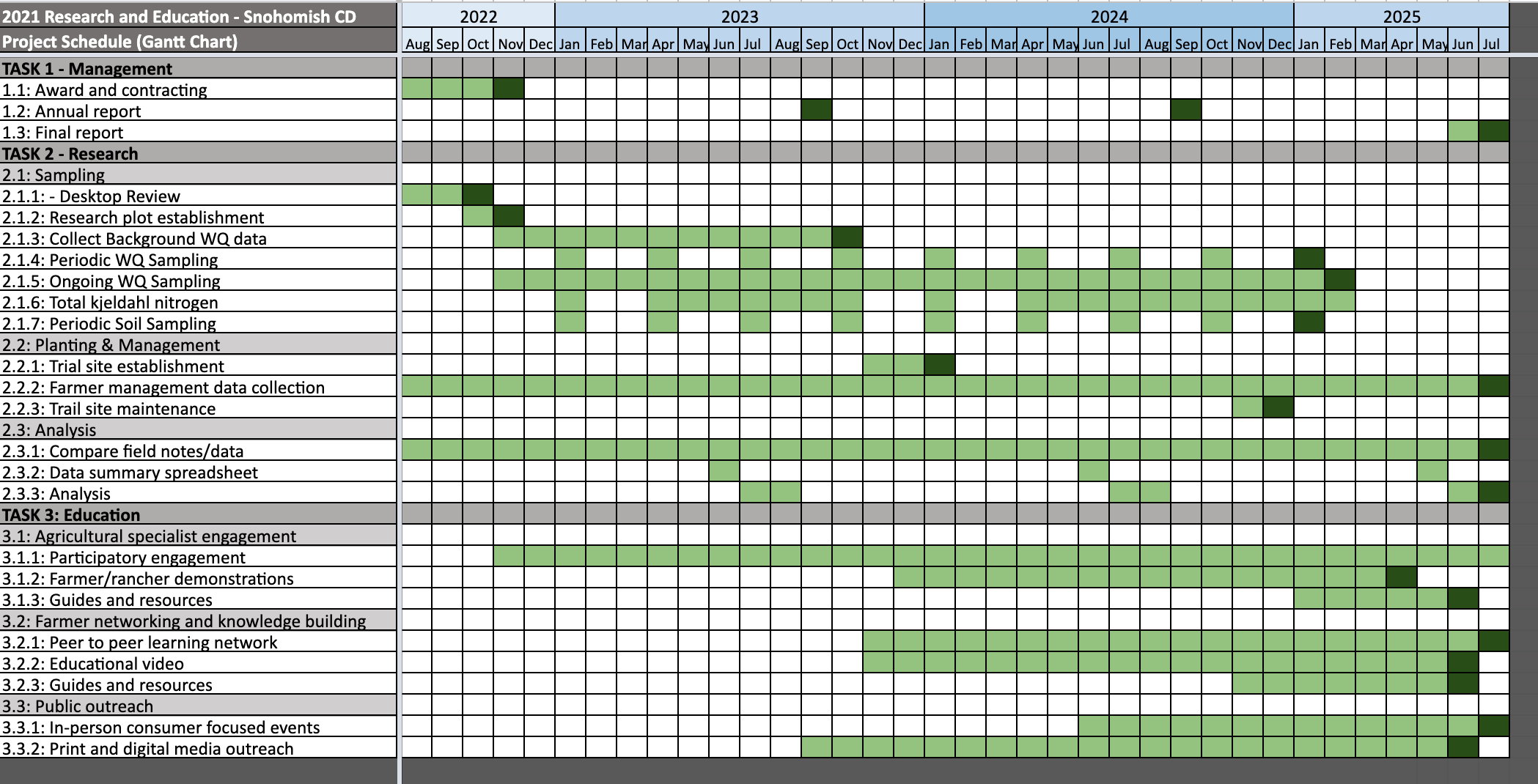
See attached Gantt Chart for more details
Cooperators
- - Technical Advisor - Producer (Researcher)
- - Technical Advisor (Educator and Researcher)
- (Educator)
- - Technical Advisor - Producer (Researcher)
- (Educator)
- - Technical Advisor (Researcher)
- - Technical Advisor - Producer (Researcher)
- - Technical Advisor (Educator and Researcher)
- - Technical Advisor (Educator)
- - Technical Advisor (Researcher)
Research
The use of private land for agricultural production includes regulations governing specified distances from watercourses, waterbodies, wetlands, or tidal shorelines. Most states and localities adopted these practices in the 1960s, calling these specified distances “setbacks” or “buffers”, serving to protect critical areas from pollution, for preservation of habitat, and the protection of structures from flooding or erosion. These buffers are intended to separate waterbodies from potentially polluting activities. For commercial agricultural lands, these distances are typically lesser distances for the purposes of production.
While buffers are quite common in regulations across the United States, very little research has been done regarding the effectiveness of these setbacks in preventing contamination from non-point source pollution.
Measurements of soil and water resources in their existing condition, or quality, are typically collected within the top six inches of soils. These top six inches are the most important indicators for non-point source pollution runoff, where surface waters mix with soil. Runoff becomes more important relative to the nutrient load within seasonally-wet areas and other critical areas, where nutrient loading may be significant for aquifer recharge, transport via subsurface drainage, and/or downstream discharge into waterways.
The scientific efficacy of working buffers is largely unknown due to a lack of scientific research providing soil- and water-quality data. It is the intention of this research to lay the foundation for obtaining the necessary metrics for both policy decision-makers and producers, to find a win-win situation between buffer regulation and production for farmers.
During this three-year grant, we utilized three pilot sites, one within each of the Skagit, Snohomish, and Whidbey Island Conservation Districts’ boundaries. In approximately the first six months of the grant, we performed literature and desktop reviews to establish optimal location placement and equipment type for each individual pilot site, based upon hydrogeography and soil type, to maximize the efficiency of soil- and water-quality data collection. Prior to any field alterations we will install all research-related equipment, take appropriate samples, and collect a year of baseline data. Immediately following we installed agroforestry orchards within known seasonally-wet buffers on the commercial agricultural pilot sites, collect a year’s worth of data downstream of the installed working buffer and continue collecting baseline data upstream of the altered area, as a control. In the last six months of the grant, with the first-ever data set collected, we began compiling data for future analysis at a later stage of research. Our long-term goal was to provide sufficient research in a multi-phased project, to obtain sufficient data and information over many years, to elicit local policy change for the benefit of both the environment and agriculture producers.
Objective 1: Strategy identification
The intention of this objective was to complete an analysis of the conditions of each of the three pilot sites, to ensure that the selection of equipment, sampling locations, quality assurance, and a Quality Assurance Project Plan (QAPP) are thoroughly examined. A hypothesis and null hypothesis was identified for each location, as each site was treated as independent pilot sites.
- We selected three fields for this experiment based on the following criteria: 1) landowner willingness; 2) presence of wet areas; 3) geographic distribution for visibility across all conservation districts. We conducted a desktop review to establish watershed characteristics including topography, drainage patterns, climate data, water table, and available geohydrology data. We analyzed pre-existing soil and/or water quality impairments for each site and highlight noted impairments in relation to current regional standards.
- Through desktop review and on-site visits, we determined the appropriate data collection equipment for purchase and installation at each pilot location. We used both automated samplers and manual sampling for more comprehensive data collection and to keep costs down. The strategy identification intended to clarify:
- Hydrogeology
- Climate data
- Drainage flow
- Water table
- Watershed boundaries
- Soil type
- Anticipated equipment includes water-level loggers and in-situ nutrient collection for water-quality; shovels, containers, and personal protective equipment for soil-quality sampling.
- Field personnel were trained on soil- and water-quality QA/QC methodology, equipment operation, basic hydrology, and safety considerations. Field personnel made monthly trips to the sites to collect data and retrieve soil and water samples.
- We followed USGS runoff methodology and sampling protocol.
- QAPP
- USGS methodologies were followed for each individual pilot site.
Objective 2: Establishing baseline data through the installation of water quality monitoring equipment prior to the installation of working buffers
The intention of this objective was to obtain data upstream and downstream of each buffer prior to any alterations, to provide relative analysis of impacts of installation of the working buffer on soil and water resources. Installation of in-situ temperature and water-loggers, nutrient collection, and ongoing soil and water testing prior to installation of the working buffer allowed for relative analysis of potential benefits of a working buffer and existing buffer
- We established a twelve-month baseline dataset for each site prior to installation of working buffers.
- We supported the Education Team in their video production showcasing the process.
Objective 3: Working buffer installation
The intention of this objective was to install an agroforestry orchard within each working buffer, as the parameter of change to be measured.
- Based upon information obtained in the previous objective, an agroforestry orchard was installed within the buffer of the seasonally wet areas at all three trial sites.
- A desktop review was conducted to ensure that plant selection was suitable for soil and water conditions. Components identified include:
- Best implementation period to suit producer needs, while considering environmental sensitivities, such as the wet-season
- Density of plantings
- Number of plantings
- Types of grafting, if necessary, for suitability in saturated soils
- Mulch and amended soils for increased planting success
- Location of the plantings was carefully considered, to include areas that leave upstream soil- and water-quality sampling locations, that continue to serve as the hypothesis control throughout the grant.
- Success of plantings was identified as a percentage of plants established vs. failed, within the working buffer of each pilot location.
- We collaborated with the Education Team to tie in opportunities for producer and volunteer participation.
- We continued to support the Education Team in their video production showcasing the process.
Objective 4: Measure soil- and water-quality effects of a working buffer at each of the three newly established trial sites
The intention of this objective was to measure soil- and water-quality changes downstream of installed working buffer, to examine the hypothesis.
- We collected samples in waterways, drainage pathways, or points of concentrated flow, with at least two (2) temperature and water-logger stations, one upstream and one downstream, and at least ten (10) soil sampling locations, at each pilot site. Soil-quality sampling stations were located in-field or at drainage outlets, depending on the topography, as assessed in the desktop review. Each of these pilot sites were easily accessible to allow for year-round sampling, and to include at least one storm-event sampling at each pilot site, as well as meteorological data from the nearest WSU weather station.
- Periodic soil sampling included: percent solids, percent water, total phosphorus, Fe-bound phosphorus, Fe-iron, nitrate plus nitrite-N, ammonium-N.
- Soil sampling occurred monthly and included total phosphorus, total nitrogen, total potassium, pH, and alkalinity.
- Water sampling included: total solids, total suspended solids, suspended sediment, dissolved reactive phosphorus, total dissolved phosphorus, total dissolved solids, nitrate plus nitrite-N, ammonium-N, total phosphorus, and specific conductance. Total Kjeldahl nitrogen was also measured.
- Ongoing water sampling will occur monthly and include: total phosphorus, total nitrogen, total potassium, pH, and alkalinity.
- Total working buffer sampling included ~12-18 months’ worth of data for initial analysis
- We supported the Education Team for farm walks.
- We continued to support the Education Team in their video production showcasing the process.
Objective 5: Compile the data
The intention of this objective was to collate and synthesize the data collected into written and visual representation for initial data collection, during the first phase of research attempting to address the hypotheses and null hypotheses identified during Objective 1, for each individual pilot site
- Through data analysis, we identified unexpected results or data gaps that future research may need to address.
- Maps, charts, and a summary of the initial impacts after the installation of each working buffer were developed.
- Success of the research was identified at this stage–e.g, were we able to successfully capture data in soil- and/or water-quality, as a direct result of the working buffer AND were the results repeatable at all three pilot sites.
- Peer review by stakeholders and volunteer scientists
Objective 6: Identify what changes are observable within the timeline of this grant and where further research is needed
The intention of this objective was to review the data to identify what changes are necessary in the next phase of the project, to ensure future success in identifying whether or not working buffers can sustain or improve soil- and water-quality while also increasing production margins for farmers; a check and balance to ensure that the research design is capable of meeting the objectives identified in this grant.
- Data analysis began to show challenges or successes of new in-field buffer systems, but are unlikely to be conclusive.
- The above analysis began to show us a comparison of newly established in-field working buffer systems and initial effects of the first year, on soil- and water-quality.
- Further data collection to observe soil- and water-quality data on agroforestry working buffers as they age, to include more established systems with larger root volumes, will be necessary for a comprehensive look at these systems.
- As this project is the first step in a multi-phased project, no final conclusions about the efficacy of multifunctional working buffers can be identified as a result of the present data set.
- We submitted our findings for peer review stakeholders and volunteer scientists.
- We continued to provide support to the Education Team to promote public awareness of multifunctional working buffers.
Objective 7: Identify “Lessons Learned” with possible benefits/limitations of working buffer systems to improve water-quality
The intention of this objective was to reflect upon the first phase of this multi-phase project to ensure that “lessons learned” are shared and identified throughout its duration, and not just at the end. We anticipate significant interest in this research as it is the first of its kind.
- Analysis of data for outliers identifying potential causes/sources was done by comparing automatic temperature and water-logger equipment data, field notes, sample data sheets, and laboratory data results.
- We organized data by soil- and water-quality, and -quantity by laboratory code constituent concentrations. When we received results, we matched them with time and location data for each individual pilot site. All information was placed in a data-summary spreadsheet for each station, checked, and finalized at the end of each water year.
- Analysis of the weather stations, producer experience, baseline data, and constituent loads were determine whether the first years data represents a “typical” runoff event or is anomalous, potentially influenced by upstream activities. We compared our findings with “typical weather” as defined by an analysis of 10 years worth of data to establish prior information on a “typical” weather year, using the WSU agronomical weather stations, closest to each pilot site location.
- We provided support to the Education Team to promote public awareness through public events and/or webinars.
- Continued to support the Education Team with video production.
- While the overall goal was to assess whether working buffers are efficacious at reducing pollutants, this phase of the grant focused on the collection of baseline data with descriptions of soil- and water-quality to be used statistically during later phases of continued research.
Objective 1: Strategy Identification
The QAPP was completed and is now linked. After desktop reviews of sites, site visits, equipment selection, and installation of monitoring equipment our researcher has continued to collect monitoring data and goes out to each site to collect soils and additional WQ samples for lab testing. The data collection concluded in May 2025. Water quality sampling continued through May 2025. Water and soil analyses were conducted in summer 2025 to evaluate research hypotheses and provide recommendations for future research.
Objective 2: Establishing baseline data through the installation of water quality monitoring equipment prior to the installation of working buffers
We did not anticipate being able to identify any benefits prior to the final analysis as plantings were brand new and plants were still establishing themselves. As discussed below, we anticipate conducting a second round of planting and will analyzed all data in summer 2025 to identify any benefits to soils and water quality that the data can show us in such young perennial plantings. As discussed elsewhere, Such perennial systems take years to reach maturity and have their full impact on soil and water quality, but this project ensures that we will have documented excellent baseline data for these systems.
Soil and water laboratory analyses were conducted between late-2022 and mid-2025. Soil samples were taken from upstream and downstream locations at each of the three farms eight times between February 2023 and May 2025. Water samples were collected from the three farms between December 2022 and May 2025. During this period, Tangled Thicket Farm and Sweetwater Farm were each sampled nine times, while Reinhard Ranch was sampled eight times.
Water temperature data were collected continuously at the three farms between November 2022 and January 2025. Dataloggers in the target streams measured water temperature every 15 minutes.
Objective 3: Working buffer installation
Multifunctional working buffers were installed at each of the three farms. Some plant mortality was observed and therefore additional infill planting occurred. Maintenance activities were conducted at Reinhard Ranch to promote tree health and reduce pressure from pasture grasses and invasive species.
Research Tasks:
Task 1: Desktop review of each site - Completed
Task 2: Research plot establishment - Completed
Task 3: Collect background water quality data - Completed
Task 4: Periodic and ongoing water quality sampling - Completed
Task 5: Periodic soil sampling - Completed
Task 6: Trial planting establishment at 3 sites - Completed
- Reinhard River Ranch (Snohomish County) & Raising Cane Ranch (Snohomish County) - adjacent properties. Because the Reinhard family decided to not participate in additional planting, we sought and received permission from Dr. Marlow to infill plants at Raising Cane Ranch agroforestry project directly adjacent to the Reinhard property. Nick Pate has been working with the District for several years to implement a large-scale farming and agroforestry project.
- Sweetwater Farm (Island County)
- Tangled Thicket (Skagit County)
Task 7: Farmer management and maintenance data collection - Completed. Information about farmer management and maintenance activities is included in the final data analysis, along with recommendations for management and maintenance for future multifunctional working buffers.
Task 8: Data analysis and summary - Completed. Data related to soil, water, and management/maintenance are discussed in a data analysis report included as an information product.
Research outcomes
The soil and water data collected in this study are intended to provide baseline information on the condition of soil health and water quality for future comparison with conditions under the mature buffer plantings. By collecting thorough data over the course of several calendar years (and thus several cycles of rainy and dry seasons) we have established a robust dataset describing baseline soil and water conditions in the study areas. While some differences may be observed between upstream and downstream water quality conditions, we cannot conclude that the implementation of the multifunctional working buffer was responsible for these differences.
For many water quality metrics, conditions in downstream samples may have been more favorable than those upstream. Average (both mean and median) total phosphorus and total nitrogen levels were lower in downstream samples than in upstream samples at all three farms. Average total dissolved solids (TDS) were lower in downstream samples than upstream samples at Reinhard River Ranch and Sweetwater Farm. It is important to note that these differences were not statistically significant.
For some metrics, water quality conditions downstream of the planting may have been more impaired than those upstream. For example, for both post-planting sampling dates at Tangled Thicket Farm, total dissolved solids (TDS) were higher in the downstream sample than in the upstream sample. Average conductivity was higher in downstream samples from Tangled Thicket Farm than in upstream samples. These differences at Tangled Thicket Farm were statistically significant (P < 0.05).
For the Sweetwater and Tangled Thicket sites, water quality samples were collected only twice after the buffers were planted; at the Reinhard site, one post-planting water sampling occurred but a sample was only collected from the upstream site which precludes any comparison between upstream and downstream conditions. Some difficulties were encountered in achieving the desired frequency of water testing. For example, the waterways occasionally ran dry, making it impossible to collect water samples and creating anomalies in the water temperature data. We recommend selecting sites for future research based on the year-round presence of water. We also recommend selecting sites which occupy similar positions within their respective watersheds (e.g., upland or lowland). These sites should be as isolated as possible from contamination sources outside of the farm. Since weather conditions can vary substantially across microclimates, we recommend installing weather monitoring stations at each study site to facilitate the analysis of the impacts of multifunctional working buffers on water quality metrics such as water temperature.
Additional research will be needed to evaluate the impacts of mature multifunctional working buffers on soil health and water quality. This research should be conducted at regular intervals (perhaps every 5 years) as the trees and shrubs planted in these buffers mature, allowing for conclusions to be drawn about the impact of mature buffer plantings before and after canopy closure.
Education and Outreach
Participation summary:
Objective 1: Engage agricultural specialists, planners, and professionals who provide technical assistance and guidance to farmers in participatory research on the effects of working buffers on seasonally wet marginal farmland
We invited professional partners to participate in our planting days at each farm during the spring of 2024. In the spring of 2025, a site tour was given by each farmer allowing partners to connect and hear directly from farmers. An introduction on what "working buffers" are and how they are designed was given by Whit Barrett, Agroforestry and Agriculture Planner. Agricultural stakeholders, including local farmers and staff of relevant government agencies (such as the Washington state Department of Ecology) attended farm walks.
We worked with professional partners on data collection. We collaborated on data analysis to ensure that our findings are statistically robust and presented in a way that allows others to build effectively on the work we completed through the course of this project.
Objective 2: Create a farmer friendly guide to aid farmers in designing and establishing working buffer practices on marginal farmlands, and foster peer-to-peer networking and education between farmers
We convened technical staff in October of 2023- October 2024 to outline a farmer technical guide on designing and establishing buffer systems on marginal farmlands. This technical guide is adapted for the internet and publicized using existing Conservation District websites to ensure that the information remains accessible to farmers throughout the study area and the region. Additionally, in 2025, we worked with a creative design consultant to finalize and print the farmer technical guide. The final print version of the farmer technical guide is included as a final deliverable, and an online version will be posted in the near future to ensure that farmers across the country can access this information. We worked closely with an independent illustrator to develop a practical diagram of a working riparian buffer that can be incorporated into print and web resources.
We conducted 8 Agroforestry workgroup meetings educating and networking professionals and landowners in the agroforestry space. Meetings offered a guest speaker to educate on and relevant agroforestry topic, with time for networking and knowledge sharing at the end. Agroforestry workgroup topics included silvopasture, forest farming, and riparian forest buffers, as well as general discussion of agroforestry Best Management Practices. The purpose of these meetings was both to share knowledge around specific agroforestry practices and also to build a community of agroforestry practitioners in the region. These meetings took place on the following dates:
- April 12, 2023: Indigenous Agroforestry
- June 14, 2023: Economics of Silvopasture
- October 11, 2023: Agroforestry and Land Use Policy
- December 13, 2023: Silvopasture in PNW
- February 14, 2024: Nutshell talks (short presentations on range of agroforestry practices)
- April 10, 2024: Forest Farming
- January 23, 2025: Silvopasture
- April 24, 2025: Riparian forest buffers
SCD and partners fostered peer-to-peer networking and exchange of knowledge through farm walks at agroforestry planting sites. These farm walks were targeted toward farmers and landowners considering implementing working buffers on their properties and provided opportunities for farmers with experience with the method to provide advice and discuss their lessons learned. Several farmers who attended these farm walks have reached out to Conservation District staff to request technical assistance with agroforestry practices.
Objective 3: Create a public outreach campaign providing education opportunities for farmers and consumers in the region on the unique and innovative nature of working buffers to address environmental and production challenges and to promote specialty crops grown in these buffers as a new and evolving market unto themselves
In 2023, the District presented at the Savanna Institute's Perennial Farm Gathering and also at the national agroforestry conference. PFG 2023: Agroforestry Ingenuity in the Pacific Northwest webinar
The Snohomish Conservation District Agroforestry program published a semi-regular agroforestry newsletter "Farm and Forest" with a readership of over 450 across the country. A total of 12 newsletters were published during the grant period.
The spring 2025 issue of the SCD Farm and Forest featured an interview with Carrie Brausieck.
We periodically posted additional social media items which promoted opportunities to learn more about working buffers and highlighted additional educational materials developed.
We have continued engagement with professional partners around building awareness of Bountiful Buffers (Working buffers) and how they benefit both ecosystems and landowners through presentations and planting events at our partnering farms.
We have conducted outreach strategy meetings once a month from April 2023 to October 2023 and then from January 2024 to April 2024. Extensive planning and production meetings related to the farmer friendly guide were conducted in early-2025.
Meetings include farmer guide design, planning engagement events, working on video production, marketing engagement, and more.
We conducted farm tours with all of our cooperating farms in the spring of 2025. We will be disseminating our Farmer Guide online and in-print. One researcher involved in this project attended the 2025 North American Agroforestry Conference and discussed multifunctional working buffers with agroforestry professionals from around the continent.
Education and Outreach Outcomes
Recommendations
We conducted a wide variety of outreach and education events to build awareness of the Bountiful Buffer system. These activities included print outreach (such as newsletters and developing a farmer guide) and in-person activities (primarily farm tours).
The Agroforestry for Wet Soils and Waterways farmer guide was developed through a collaborative effort involving staff at several conservation districts. This approach helped to ensure that practitioners with diverse technical experience were engaged and that the recommendations included in the guide could be applied throughout the Puget Sound region. We recommend continuing this approach in the development of future guides and including group working sessions with CD staff and farmers throughout the process.
The farm walks conducted through this project were very successful in drawing in farmers and land managers interested in implementing working riparian buffers on their own land. These farm walks placed the farmer in the position of sharing their experience with the practice and allowed others to ask practical management questions that CD staff may be less familiar with. These events resulted in multiple requests for assistance from farmers interested in additional technical assistance related to implementing working riparian buffers on their property. We recommend including similar farm tours in future projects and ensuring that the cooperating farmers are the primary speakers at these events.
Results
We have continued engagement with professional partners around building awareness of Bountiful Buffers (Working buffers) and how they benefit both ecosystems and landowners through presentations and planting events at our partnering farms.
We have conducted outreach strategy meetings once a month from April 2023 to October 2023 and then from January 2024 to April 2024. Extensive planning and production meetings related to the farmer friendly guide were conducted in early-2025.
Meetings include farmer guide design, planning engagement events, working on video production, marketing engagement, and more.
We conducted farm tours with all of our cooperating farms in the spring of 2025. We will be disseminating our Farmer Guide online and in-print. One researcher involved in this project attended the 2025 North American Agroforestry Conference and discussed multifunctional working buffers with agroforestry professionals from around the continent.
- appropriate crops for working buffers in our region
- working buffer planting design and implementation
working buffer planting design and implementation
appropriate crops for working buffers in our region