2010 Annual Report for CNE10-078
Enhancing Farmer Access to Sustainable Shellfish Aquaculture Areas: An Ecosystem Approach
Summary
Preliminary mapping of a potential subtidal aquaculture development area (ADA) straddling the boundary between the towns of Provincetown and Truro has been completed. Mapping was conducted using a Geographic Information System (GIS). Local knowledge of other human uses (lobster fishing, etc.), management boundaries, ideal grow-out conditions, and existing shellfish abundance were incorporated using an interactive process by employing the GIS software during group and individual meetings with participants and stakeholders.
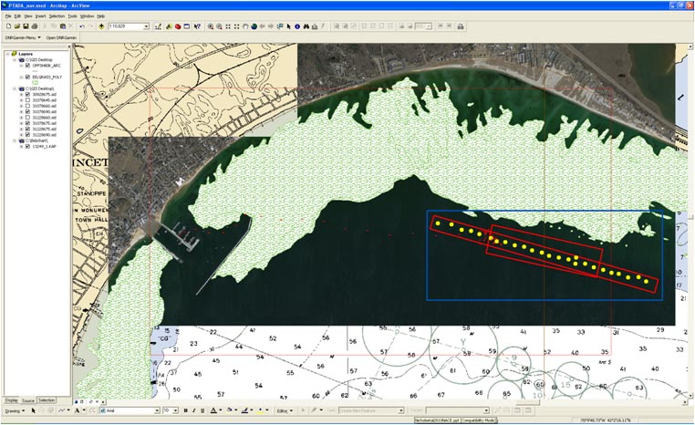
Information on eelgrass distribution and bathymetry was used to delineate a 50-acre ADA site, consisting of two 25-acre sites (the maximum allowed for a municipality) abutting one another across the town line and following the 20’ depth contour (Figure 1). Acoustic backscatter data from an interferometric sonar system was used to classify seafloor habitat type, indicating no eelgrass and a smooth, sandy bottom. One and half days of dive survey work were completed. At each of 25 stations (Figure 1), an underwater transect was surveyed and photographs taken to qualitatively assess bottom habitat type and a 1 meter quadrat was sampled to quantify existing shellfish abundance. The results of the dive surveys corroborated the sonar data, indicating no eelgrass present and a smooth bottom.
The only shellfish species encountered was the surf clam; abundance at all stations was at or below 1 organism per square meter. Additional dive surveys may be conducted to assess storm impacts on the site, based on evidence of a dynamic environment in the eastern section of the side indicated by sand waves. Results of the preliminary mapping were presented at the Northeast Aquaculture Conference and Expo (see Impacts and Contributions/Outcomes).
Objectives/Performance Targets
Outreach has been conducted by all project participants in order to assess the potential utilization of an ADA by local growers and gather local knowledge incorporated into the mapping process.
All of the preliminary data gathering and mapping necessary to delineate a potential ADA has been completed. Pending approval of the shellfish committees of each town, final maps will be drafted and submitted to the Selectmen of each town. It will be up to the towns to proceed with the application process for the necessary state and federal permits for ADA designation.
Accomplishments/Milestones
The outreach and mapping efforts were conducted over the first several months of the project (June-November) and involved an iterative process during which maps were reviewed by participants and stakeholders during individual and group meetings, culminating in a completed preliminary map of a 50-acre potential ADA.
The field components of the project were slightly delayed by weather, which was counterbalanced by the efficiency of the dive team. In November, 25 dive stations were completed in half of the time budgeted (1.5/3 days), leaving the remainder of the allotted survey time for a survey of storm effects on the potential ADA site. The sonar data was incorporated into the project later than anticipated due to a combination of weather and vessel malfunctions – while the sonar data collection was not part of the proposed project, data acquisition was delayed by the problems encountered in the field. The sonar data was deemed too important to proceed without its incorporation into the mapping process.
The delays in the field component of the study and the winter holidays have pushed back the submission of the final report to the towns until January, when the Selectmen of each town will return to session.
Outreach to the community has been successful throughout the project, and presentation of project results to management agency representatives while at the Northeast Aquaculture Conference and Expo in December (see below) has laid the foundation for a smooth transition into the permitting process, should the towns wish to proceed.
Impacts and Contributions/Outcomes
Seven meetings of the Provincetown Shellfish Committee and two meetings of the Truro Shellfish Committee were attended by the project PI and one or more Participants. One of the meetings was a joint assembly of both town committees with the express purpose of discussing this project. The shellfish committee meetings have served as a mechanism for information flow during the mapping process as well as a vehicle for outreach to shellfish farmers and the community.
Results of the preliminary mapping were presented at the Northeast Aquaculture Conference and Expo (presentation attached, December 2-3), generating valuable feedback from conference participants, including growers and state and federal managers. The project PI and one of the participants briefed the lead state management agency representative, gaining positive feedback and laying the foundation for the first steps of the ADA permitting process. Abstracts have been submitted to a local natural history conference and the National Shellfisheries Association annual meeting – both forums will provide platforms for further outreach and feedback from both local and national audiences.
Collaborators:
Shellfish Constable
260 Commercial Street
Provincetown, MA 02657
Office Phone: 5084877000
Farmer
Seafood Divers, Inc.
PO Box 1145
Provincetown, MA 02657
Office Phone: 5082370875