Final report for EW18-018
Project Information
Livestock grazing is an important land use throughout the western US, and ranchers need to make management decisions quickly in response to current conditions. The University of Idaho’s Rangeland Center identified land use policies limiting ranchers’ flexibility to account for annual variations in forage, water, disturbance, and market conditions as a challenge to sustainably managing Idaho’s rangelands. This has led to an effort by the Center to develop an “outcome-based management” paradigm that would give ranchers more flexibility to make management decisions regarding grazing on private and leased public lands. However, the success of such adaptive management will hinge on quickly and accurately assessing condition of rangelands and coordinating monitoring activities between ranchers and public land managers. Outcome-based management will require a new paradigm for monitoring rangelands that adds easy-to-implement quantitative methods to existing monitoring, leverages the ability to combine monitoring data from different sources, and emphasizes cooperative monitoring between ranchers and public agencies. Achieving this in Idaho will require developing significant training and support materials for ranchers and rangeland professionals. This project’s objectives were: 1) consolidate existing training materials for three monitoring techniques (photo monitoring, LandPKS, BLM quantitative monitoring) into consistent formats emphasizing understanding and interpreting monitoring indicators and method implementation; 2) demonstrate the compatibility of the rapid LandPKS method with other methods used by BLM, and illustrate how methods can be used together for monitoring grazing effects in outcome-based management; 3) develop training modules for using the three methods together for management decision making; and 4) host workshops for ranchers and rangeland professionals on the suite of monitoring tools and how they can be used together. The project goal was to increase ranchers’ awareness and use of compatible rangeland monitoring programs in Idaho and increase the success of outcome-based rangeland management.
The goal of this project was to provide training on and demonstration of rangeland monitoring methods that could be used in outcome-based management in Idaho. This project focused on developing training materials for three monitoring techniques (photo monitoring, LandPKS, BLM quantitative monitoring) and illustrating how those techniques can be used together by ranchers and public land managers to support sustainable grazing. Specific project objectives were:
Refactor existing training materials for photo points, LandPKS, and BLM quantitative monitoring into consistent, modular formats that emphasized: 1) understanding the indicators and how to interpret the data, 2) understanding how the techniques work, and 3) learning how to implement the techniques.
Demonstrate the compatibility of the LandPKS methods with a set of quantitative methods used by BLM and illustrate how data from all three methods (photo monitoring, LandPKS, and quantitative indicators) can be used together for monitoring grazing effects for outcome-based management.
Develop training modules for how to use the three different sources of monitoring data together for management decision making.
Develop and host workshops for NRCS Specialists and Extension Educators, ranchers, and agency land managers on the suite of monitoring tools and how they can be used together.
Develop and launch a training hub on the LandPKS website to host video and other online training materials on how to implement and use the LandPKS method.
Throughout the Western U.S. livestock grazing is an important land use, and many ranchers operate on both private and leased public lands. With increasing wildfire and dramatic inter-annual variations in precipitation as well as markets, ranchers need to make management decisions quickly in response to current conditions. However, many ranchers operating on public lands feel that they are passive recipients of decisions from an inflexible administrative system rather than active decision makers regarding their livestock management. The 2016 Strategic Plan for the Rangeland Center at the University of Idaho, a product of public listening sessions throughout Idaho’s rangelands, identified “Land use policies that limit rangeland management flexibility to account for annual variations in forage, water, drought, pests, disturbance, market conditions, etc.” as a challenge to sustainably managing Idaho’s rangelands (University of Idaho Rangeland Center 2016).
These challenges have led to a joint-effort by the Bureau of Land Management (BLM) in Idaho, the University of Idaho’s Rangeland Center and Policy Analysis Group, private ranchers, other federal and state agencies, and NGOs to propose an “outcome-based management” paradigm that would give ranchers more flexibility to make management decisions regarding livestock (e.g., stocking rates and grazing timing) on public lands. This new approach seeks to address the regulatory constraints that have hampered adaptive management historically (Moir and Block 2001, Ruhl 2007). However, the ability of outcome-based management to achieve sustainability of rangeland health and rancher operations will hinge on being able to quickly and accurately assess the condition of rangeland resources, and coordinate monitoring activities between ranchers and public land managers.
Monitoring is a fundamental part of adaptive management (Walters and Holling 1990, Williams et al. 2011) and sustainably producing livestock on western rangelands (Herrick et al. 2012). A basic principle of adaptive management is that a period of observation follows any management action during which time the effects of the action are observed before management is adjusted if necessary. Within the context of outcome-based management, however, management changes happen frequently in anticipation of changes in environmental or market conditions, necessitating continuous collection and interpretation of monitoring data to ensure defined ecological, social, and economic outcomes are met and rangeland resources are protected. Thus, with outcome-based management, a comprehensive suite of monitoring indicators must include the ecological, social, and economic aspects of rangeland systems. This proposal focuses on monitoring ecological indicators for outcome-based management. Parallel efforts are underway to develop social and economic indicators as part of a monitoring framework compatible with ecological indicators.
Traditionally, rangeland condition monitoring by ranchers has consisted of qualitative, easy-to-implement methods like photo points (Hall 2001), whereas public agencies have tended toward more time-consuming quantitative monitoring methods (Coulloudon et al. 1999, Toevs et al. 2011). However, this approach for ecological monitoring may not function for outcome-based management because photo monitoring lacks the rigor to detect fine changes at site-scales, and quantitative approaches are too time-consuming to repeat everywhere on an annual basis. Thus, outcome-based management will require a new paradigm for monitoring rangelands that adds easy-to-implement quantitative methods to existing monitoring, leverages the ability to combine monitoring data from different sources, and emphasizes cooperative monitoring between ranchers and public agencies. Realizing this new monitoring paradigm in Idaho rangelands will require the development of significant support materials and training of ranchers and rangeland professionals.
For outcome-based management to succeed, there is a need for an easy-to-implement, quick, and quantitative monitoring protocol to fill the gap between photo monitoring and more intensive quantitative monitoring. One such method is the Land Potential Knowledge System (LandPKS), a mobile-phone-based application for monitoring the condition of rangelands relative to their potential (Herrick et al. 2013, 2016, https://www.landpotenial.org). Originally developed to aid pastoralists in sub-Saharan Africa make sustainable land management decisions under changing climate and soil conditions, LandPKS could fill the methodological gap between photo monitoring and quantitative monitoring and play a role in helping ranchers monitor the ecological indicators for outcome-based management. The indicators measured by LandPKS were designed to be consistent and interoperable with common quantitative methods used by the BLM (e.g., through the Assessment, Inventory, and Monitoring program and on many long-term trend sites). However, while training resources exist for implementing LandPKS, the knowledge of this system in the U.S. is low, and its value for ranchers as a monitoring tool and how to combine LandPKS data with other data sources has not been demonstrated.
In outcome-based management, decisions about stocking rates and timing need to be made despite incomplete or imperfect information on rangelands. Thus, it becomes important to be able to use information from many different sources to support management decisions. This has been termed a “multiple-lines of evidence” approach (Michalak et al. 2017), and has been demonstrated in environmental risk assessments (Bland et al. 2017, Melcher et al. 2017), and commonly used informally in rangeland management. However, with the increased information demands of outcome-based management, demonstrations of multiple-lines of evidence approach to monitoring are needed to illustrate how data from different methods can be combined and interpreted to support management decisions. While training materials are generally available for individual monitoring methods, there currently exists little in the way of training materials for how these methods can be combined and interpreted to support outcome-based management.
Cooperative monitoring of public grazing lands is a way to obtain necessary monitoring data for outcome-based monitoring and maintain positive working relationships between ranchers and public land managers. The opportunity for cooperative monitoring between the BLM and grazing permit holders (ranchers) was established in a 2004 memorandum of understanding (renewed September 2017) between the BLM and the Public Lands Council (BLM MOU WO20-2001-01). This agreement stipulated that ranchers may participate in monitoring conducted by the BLM related to their grazing leases, and that ranchers may collect and submit additional monitoring data collected with BLM-approved techniques (and that meet BLM data quality standards). However, the quantitative and time-intensive nature of many monitoring techniques used by the BLM may discourage ranchers from implementing them. In Idaho, an agreement between the BLM and Idaho State Department of Agriculture (BLM MOU ID-SO-2014-07) encourages photo monitoring conducted by ranchers on their allotments and establishes a mechanism for those photos to be considered in Rangeland Health Assessments pertaining to those allotments. Both agreements provide the opportunity for rancher-collected data to contribute to management decision-making, which will be necessary given that agency personnel will not be able to collect monitoring data frequently enough to meet the needs of outcome-based management. Rapid, quantitative methods that are consistent with BLM’s quantitative monitoring approaches (e.g., LandPKS) could also be a valuable contribution to this process. Training in monitoring methods that can contribute to cooperative monitoring is necessary for this to succeed.
The goal of outcome-based management is to empower ranchers with the flexibility to be active participants in managing the public lands on which they operate. However, enabling management that is responsive to changing conditions could carry a large information burden for ranchers. Unless ranchers are prepared for what kinds of data to collect to gauge outcomes, how to interpret those data, and how to combine data from different sources, attempts at outcome-based management may fail to improve rangeland and ranch sustainability. This proposed project is unique in that it does not seek to develop or implement new techniques for monitoring, but to take existing programs and weave them together into a framework that can support the information needs of ranchers in outcome-based management. The University of Idaho’s Rangeland Center is uniquely qualified to address this challenge because of its diversity of expertise, years of experience, and close relationships with ranchers, agencies, and NGOs. Through this project, we will increase awareness of monitoring in the context of outcome-based management with rangeland professionals (including NRCS and Extension specialists and public agency staff) so they can advocate its use with ranchers. While not directly addressed in this proposal this project will coordinate with efforts by the University’s Policy Analysis Group to develop social and economic indicators for outcome-based management to ensure compatibility of monitoring frameworks.
This proposed work is unique from previously-funded Western SARE Professional Development Program grants, but draws on aspects of previous successful projects including: EW95-003(developed comprehensive monitoring protocols for riparian monitoring in intermountain west rangelands), EW14-024 (increased awareness of monitoring programs in Colorado), EW02-010 (developed and implemented rangeland monitoring programs for livestock), and EW10-020 (development of monitoring frameworks and implementation via workshops for professionals and ranchers). This project complements USDA-CRIS project (#3050-11210-008-00-D) from the USDA-ARS Rangeland Research Unit in Las Cruces, NM under which the LandPKS project is being developed.
Cooperators
- (Educator)
- (Educator)
- (Educator)
Education
The educational approach of this project is one of hands-on training and demonstration in monitoring techniques using the LandPKS system. Specific pedagogies include presentations and discussions of land potential and how it governs the potential of land to support different vegetation communities and ecosystem services, live demonstrations of the LandPKS app with instructors in the field, practice and coaching for participants implementing the LandPKS app, and follow-up reviews and check-ins on implementation.
Education & Outreach Initiatives
One of the first objectives of this project was to create simplified training materials for LandPKS, other commonly-used methods, and the supporting information needed to successfully use them in rangeland monitoring.
We created a number of training materials for use both in the workshops and for self-guided learning after the conclusion of this project. These included fact sheets for each of the methods we covered in the workshops (LandPKS, ISDA photo monitoring, utilization monitoring) and a fact sheet for the BLM’s AIM quantitative monitoring. We did not formally teach the AIM techniques in our workshops (focusing on the use of LandPKS instead), but did demonstrate the AIM methods and discuss their uses by the BLM so that participants were familiar with data that might be used by the BLM to support management decisions. For the classroom portions of the workshops, we developed multiple presentations relating to 1) the LandPKS application and data portal, and 2) supporting concepts that are important for understanding rangeland monitoring data (e.g., land potential and ecological site concepts, how to find local soils and ecological site information). Examples of these presentations are:
- A Landscape View of Idaho Range
- Finding Idaho Ecological Site Information.20200605
- Interpreting your data
Because COVID-related shutdowns and restrictions affected our planned activities, we put additional consideration into online training resources for LandPKS and how those might be delivered and used. The suite of online training materials for LandPKS which were developed by the USDA-ARS team with assistance from our project team are available at https://landpotential.org/knowledge/one-day-landpks-training-materials-app-v-3-0/ (Figure 1).
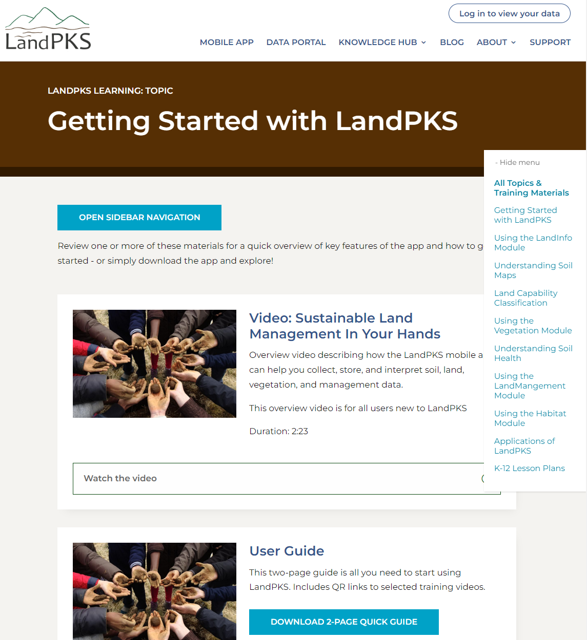
Figure 1. Screenshot of the LandPKS learning hub page with getting started training materials for LandPKS.
We also helped the USDA-ARS develop a suite of additional training videos and resources for the various LandPKS app modules as well as user guides that discuss the use of LandPKS for specific topics. For example, the utilization user guide (https://landpotential.org/knowledge/measuring-utilization/) discusses why utilization monitoring is important and how to record utilization data with the LandPKS app. The rangeland management user guide describes how to use the LandInfo, LandManagement, and LandCover modules in LandPKS to determine land potential, track management activities, and describe vegetation condition (https://landpotential.org/knowledge/rangeland-manager-user-guide/).
The expansion of the LandPKS suite of modules over the past few years has presented a problem. While LandPKS is increasingly capable for data capture and analysis related to a range of farm, ranch, and rangeland management needs, which of the growing suite of modules a rangeland manager would need to use has become challenging to communicate. To address this, we determined that more targeted resources and training materials and a new LandPKS training hub would be needed. The new learning hub, available at https://landpotential.org/learning/ (Figure 2), provide curricula developed around specific applications of LandPKS.
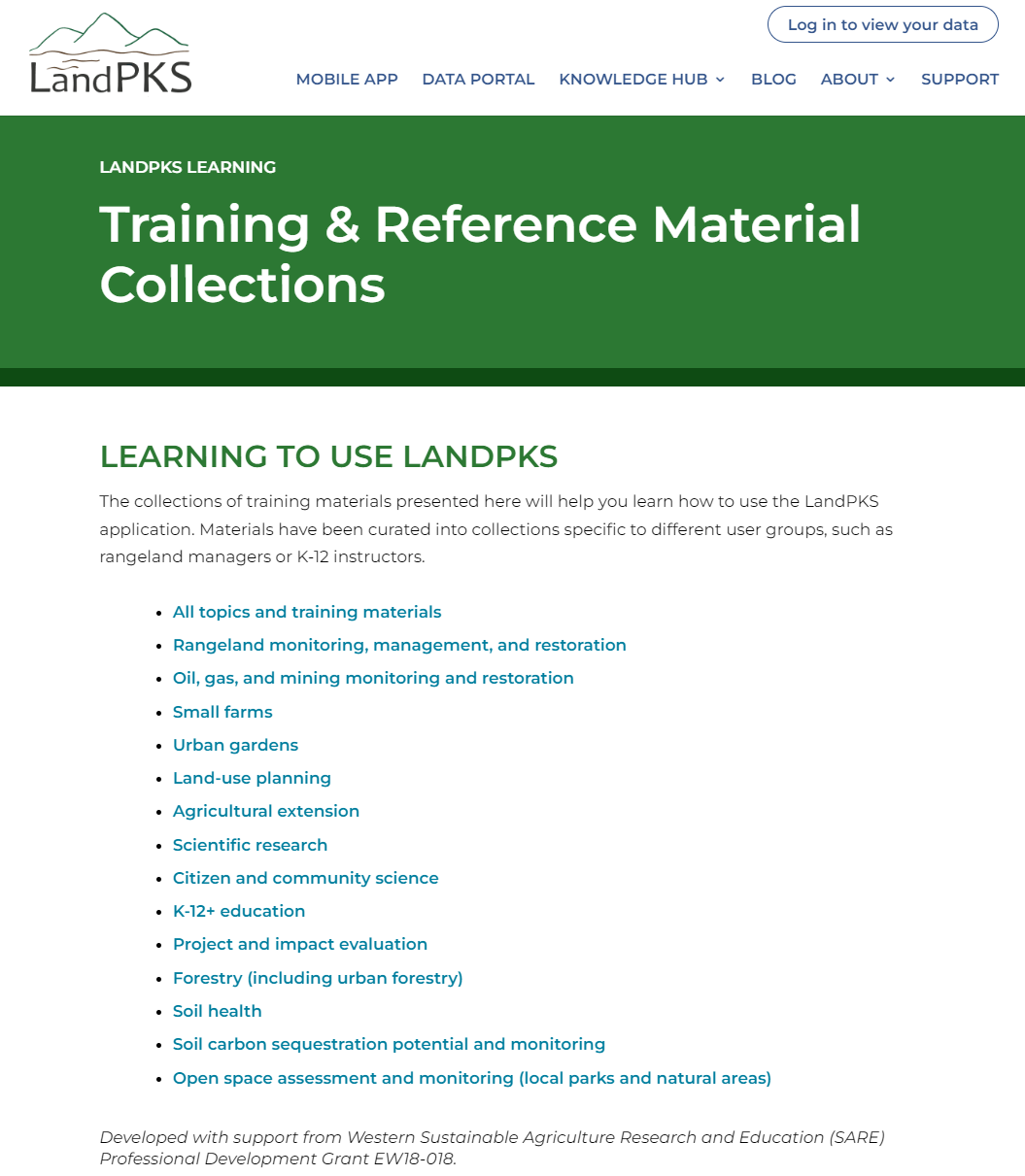
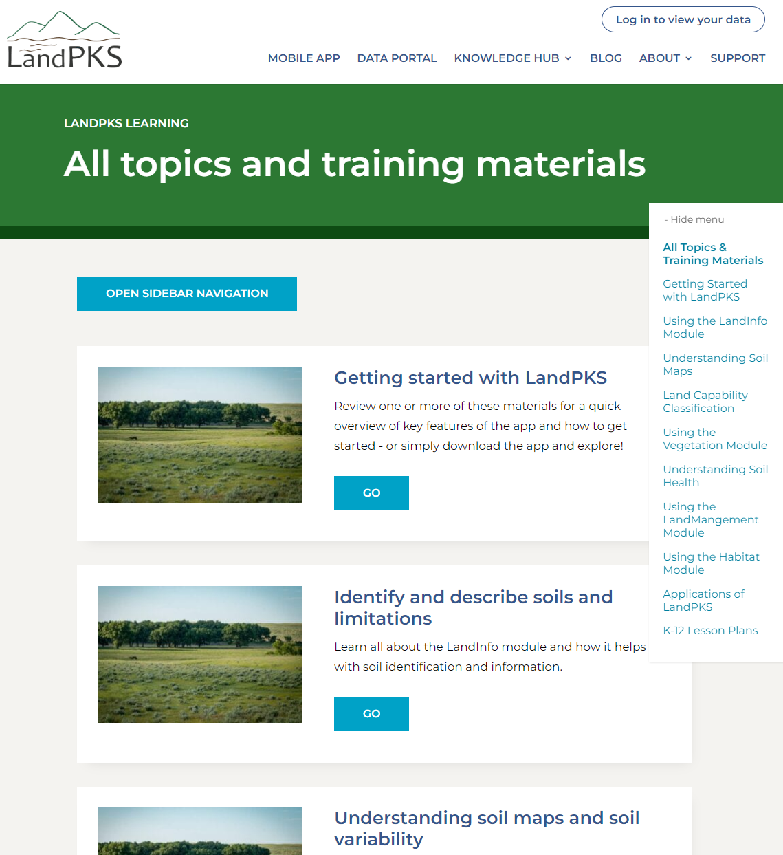
Figure 2. The LandPKS Learning Hub provides access to curricula defined for specific applications of LandPKS.
These curricula compile the various LandPKS videos, LandPKS training resources, and supporting documents related to the topics. The current version of the learning hub has a fixed set of topics for which curricula have been (e.g., rangeland management, agricultural Extension) and are being developed. Future versions of the learning hub will allow users to develop their own curriculum which would be useful for faculty developing materials for classes or Extension Educators developing materials for a workshop.
Screenshots of the LandPKS Training Hub:
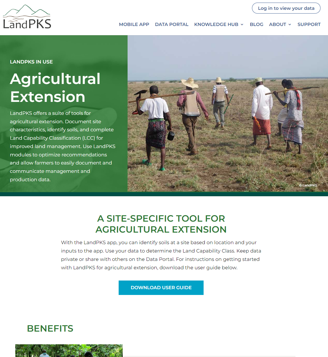
Figure 3. The Agricultural Extension page on the LandPKS Learning Hub is one of several curricula that identify relevant LandPKS modules for that topic and provide targeted training resources (e.g., videos, fact sheets, manuals).
The workshop and online training materials developed either directly as part of this project or through collaboration with project staff and USDA-ARS were effective in increasing the familiarity of workshop participants with LandPKS and its applications. In post-workshop reviews, participants rated their understanding of LandPKS prior to the workshops as, on average, 1.6 on a scale of 1 to 5. Following the workshops, participant understanding of LandPKS was, on average 3.4.
The materials developed through the grant will also provide value beyond the life of this project. We have received requests to host additional monitoring workshops in 2022 and 2023. Furthermore, the LandPKS learning hub and the developed curricula will see extensive use as LandPKS is implemented in more areas and for more agricultural-related topics.
To be successfully adopted in Idaho for rangeland monitoring purposes, the LandPKS app and data need to be compatible with other monitoring data that are being collected. The BLM’s Assessment, Inventory, and Monitoring (AIM) program is used to quantitatively measure and track rangeland condition across all BLM lands. AIM data are increasingly used in the grazing permit renewal process to evaluate land health standards related to vegetation, soils, and wildlife habitat. Ranchers or consultants wishing to track lands within their grazing permits or to contribute data to the BLM for permit renewals, need that data to be compatible with AIM. The objective of this initiative was to evaluate the compatibility of LandPKS and AIM data through a comparison study in southern Idaho.
During summer of 2020, we collected BLM AIM data and LandPKS data on 41 sites in sagebrush (Artemisia spp.) steppe across southern Idaho. AIM data collection consisted of the line-point intercept technique for estimating cover by species, vegetation height, canopy-gap intercept, plot species inventory, and soil stability (see https://www.landscapetoolbox.org for full protocols). LandPKS data collection included all the information required in the LandPKS LandCover module which include cover by plant functional group (e.g., trees, shrubs, perennial grasses), major dominant species, presence of large canopy gaps, and vegetation height by height classes (see https://www.landpotential.org for full protocols). AIM data are generally collected along three transects at a site, and LandPKS data are collected along two intersecting transects (forming a cross pattern). For the purposes of this study, we used two intersecting transects for collecting AIM data. However, even given this pairing of transect layout, observations for AIM and LandPKS do not perfectly align, and this will lead to some disagreement in measurements.
AIM data were summarized to plant functional group using tools provided by the BLM. LandPKS data were downloaded from the LandPKS Data Portal (https://portal.landscapetoolbox.org) already summarized by plant functional group. For this comparison, we considered only foliar vegetation and soil surface cover because these are the most commonly used indicators for rangeland health monitoring.
Results of the BLM-AIM and LandPKS comparison are summarized in the attached fact sheet (LandPKS versus BLM’s AIM Data: what’s the difference). The fact sheet summarizes the similarities and differences between AIM and LandPKS and then shows some results of the comparison. There was general agreement between LandPKS and AIM for cover indicators, though for several indicators there was considerable variability in the agreement. LandPKS tended to overestimate total cover and underestimate the amount of bare ground compared to AIM. LandPKS and AIM gave similar estimates of shrub cover, and there was a strong relationship between the two methods. LandPKS consistently underestimated perennial grass cover and overestimated litter cover. These consistent differences between the methods (and the variability in measures) is likely due to the fact that AIM uses a more rigorous technique for estimating cover, whereas LandPKS asks observers to visually estimate what vegetation might intercept an imaginary line above the measurement stick.
However, it is easy to read too much into method comparisons like what is presented here. While correlations were poor in some cases, differences in where the observations (e.g., LPI pin drops) were made at each site could be the cause. Also, these results are from a single crew working in a limited set of plant communities. Results may be different with a broader set of sites. Regardless, these results show that both methods tend to characterize sites similarly. More importantly, both AIM and LandPKS share common definitions for indicators such as what constitutes vegetation cover, what a rock is, and what plant litter is. This means that both data sets would be valuable as lines of evidence for understanding and documenting rangeland condition and trend.
The results of this comparison were compiled into the attached fact sheet for distribution to workshop participants. Our initial goal was to write up this comparison as a manuscript to be submitted to Rangelands. However, we determined that the comparison study on its own was not strong enough for publication. Instead, we are working with the BLM and the USDA-ARS Jornada Experimental Range on including this comparison study in a larger manuscript that discusses the value of using multiple lines of evidence for supporting land management decisions.
The goal of the Idaho Rangeland Monitoring Workshops is to provide ranchers and state rangeland management professionals with training in techniques for collecting and interpreting monitoring data to support grazing operations. In particular, these workshops focus on implementation of the LandPKS monitoring app and how it can be used with photo monitoring and in coordination with quantitative data collection by land management agencies.
The first Idaho Rangeland Monitoring Workshop was held on July 11-12, 2018 at the University of Idaho's Rinker Rock Creek Ranch near Hailey, Idaho. The workshop had 25 participants including private producers, grazingland consultants, Extension specialists, and representatives from Idaho State Department of Agriculture (ISDA). The workshop for 2018 focused on 3 techniques that could be used in outcomes-based management: photo-monitoring, utilization monitoring using a height/weight method, and the LandPKS system. Participants received training in the LandPKS method and then were able to collect some data at test locations. On the second day of the workshop, participants were introduced to the LandPKS online data portal as a location for viewing and downloading their data, and demonstrations were given on how to use the data portal to analyze and interpret the LandPKS data.
The 2019 Monitoring Workshop was cancelled due to a health emergency for one of the instructors.
Activities in 2020 were significantly disrupted in two ways due to the COVID-19 pandemic. First, when the University suspended in-person operations in spring 2020, we lost the students and interns who were working on the method comparison analysis of this project. Those activities had resumed by late fall 2020. Second, COVID-related shut downs and travel restrictions greatly reduced our ability to host workshops for this project. In June 2020, we were able to hold one workshop in Murphy, Idaho that was well attended (39 participants) and test out some of the new training materials. Workshop participants reported a significant increase in their understanding of and interesting in using the three monitoring techniques presented. 2020 was not a complete loss for the project, however, as many new training modules for LandPKS were developed and work commenced on a redesigned LandPKS website that will make it easier for users (including ranchers) to access training materials and their LandPKS data.
On June 3-4, 2021, we held a single workshop at the UI’s Caldwell Research and Extension Center in Caldwell, Idaho. The workshop was attended by 17 people including private producers, Extension Educators, state and federal agency staff, and graduate students. This workshop focused more on providing an understanding of the importance of monitoring and the basis for using land potential concepts to interpret monitoring data. An initial classroom session was followed by an afternoon of exercises in the field. Participants were instructed in and then given the chance to practice the application of LandPKS, ISDA’s photo monitoring techniques, and utilization monitoring (and the recording of utilization monitoring results in the LandPKS app). We also demonstrated the BLM’s AIM quantitative methods and held a discussion of how AIM related to other forms of monitoring. During the second day of the workshop, we taught how to find and download data through the LandPKS data portal and how to use LandPKS data and other data (e.g., ISDA photo monitoring, utilization measurements) to coordinate with agency staff for managing grazing permits.
Flyers announcing each workshop are below:
Participants in the workshops left with a working knowledge of the LandPKS mobile app and an understanding of how they could use it in management. The primary outcome of the workshops was an increased awareness of the LandPKS app. Based on post-workshop surveys, participants reported a substantial increase in their knowledge of using LandPKS for rangeland monitoring. As trainers, a secondary outcome was a better understanding of how to develop and guide trainings to help participants learn the app and see its potential uses in their operations. As per feedback from participants, workshops were adjusted to include discussions on how to share data with land-management agencies and other users, and how datasets from different sources can be used together (e.g., LandPKS data used with data collected by BLM, or with photo-monitoring).
The LandPKS application and its calculated indicators will not be adopted in Idaho if the data are not compatible with, and accepted by, the land management agencies that administer the grazing leases Idaho ranchers depend upon. One of the primary objectives of this project is to demonstrate that compatibility. The results of the ongoing comparison of techniques will help ranchers adopt the LandPKS tool and will facilitate the BLM in accepting and using rancher-collected monitoring data for grazing permit evaluation and renewal. The new LandPKS training materials and modules will also facilitate adoption and use of the LandPKS protocols and tools.
Educational & Outreach Activities
Participation summary:
Learning Outcomes
Project Outcomes
Project activities have significantly increased the knowledge of and interest in the three monitoring methods presented: LandPKS, Photo monitoring, and height-weight utilization monitoring. Training materials from the project have been distributed and continue to be improved. Interest in the project workshops is high and attendance in workshops has increased over the life of the project. Reception to the LandPKS app for outcomes-based management has been positive.
Interest in the LandPKS app and its use for rangeland monitoring has continued to increase in Idaho. This project has resulted in the formation of a group of professionals from the Idaho Department of Agriculture, Idaho Extension, and the project PIs to develop and implement improved training for rangeland monitoring aimed at ranchers and range management professionals. In 2019, the newly-formed Idaho Rangeland Conservation Partnership signed on to help organize, promote, and sponsor the Idaho Rangeland Monitoring Workshops in 2020. The ongoing comparison of LandPKS to other monitoring protocols in a multiple-lines of evidence approach will help strengthen our case for ranchers to adopt LandPKS. Discussions are underway with the BLM and USFS to include rancher-collected LandPKS data along with Photo Monitoring data in the official record of grazing permits.
5 Agricultural service provider participants used knowledge and skills learned through this project (or incorporated project materials) in their educational activities, services, information products and/or tools for farmers