Final report for FNC19-1176
Project Information
Established in 2008, EarthDance’s 14-acre organic farm school preserves a historic family farm founded in 1883. The farm encompasses 1 acre in annual vegetable and herb production, 1/3 acre in perennial fruit trees and flowers, 4.67 acres in cover crop, three high tunnels, a greenhouse, farmhouse office, an orchard of more than 250 trees, along with poultry, mushrooms, herbs, cut flowers, pasture, prairie, and mixed woodlot.
This project addressed the lack of information available about organic fruit production within the middle-latitudes of the Midwest. The Produce Efficacy Analysis and Recording (PEAR) application was developed to collect and analyze data from Earthdance Organic Farm School’s permaculture orchard.
EarthDance developed and tested a mobile application (“app”) to collect and analyze data about EarthDance Organic Farm School’s permaculture-focused fruit production, to make collection and distribution of such information easier. This project sought to address the perennial problem of record keeping and busy schedule of farmers. The Produce Efficacy Analysis and Recording (PEAR) application simplified the record keeping processes, improved old records, provided a platform for continuous data collection throughout the season. PEAR enabled the collection of crucial data, such as yield amounts, insect pressure, disease, growth measurements, and maintenance practices, to occur in the field. The application has reduced the amount of time spent handling records as it is stored to a database directly from the field and not handled again until reporting. This eliminated the double-handling that occurs during the computer entry process from field journals or other paper records.
Additionally, the data analysis now available will allow for accurate reporting of profitability, variety yield comparisons, and the identification of best practices for midwest organic fruit production. This initial year has established a platform and process for regional research to be conducted should the project be expanded to other sites.
The objective of this project was to develop and test the PEAR Application in order to collect and analyze data about EarthDance Organic Farm School’s permaculture fruit production. The goals of this objective include:
- Reducing labor by eliminating problematic paper documentation and centralizing electronic records.
- Providing a visualization of organic fruit production data through maps and analytical reports.
- Creating a platform that will serve as a launching point for regional system-level research in organic fruit production.
Cooperators
- (Researcher)
Research
Some foundational work was needed prior to the growing season, primarily updating records and application coding. An orchard inventory was conducted to account for any new trees planted or ones that had died since the initial orchard installation. This was done to make the tree tagging process as simple and efficient as possible, it was vital to have complete and current records to start the project. Given it was late winter - early spring, tree identification was somewhat challenging in the absence of fruit or leaves to aid identification. It is recommended to audit orchard records in mid-season, if unfamiliar with the varieties of a specific orchard.
Concurrent with records updating, the first 90 days of the grant period were devoted to application coding and creating a database. Orchard observations began once the database was created and a rudimentary application was available. In the initial project proposal, the team had planned to train the EarthDance farm team on the usage of the application. However it quickly became apparent that a dedicated observer and researcher was needed, given the limited amount of time by the farm team. Data collection began in May and continued throughout the growing season until the final harvest in the fall.
To collect tree-specific data, a waterproof placard printed with a QR code was attached to each tree. Using the mobile application, an observer photographed the QR code, which opened a webpage specific to the tree being examined. This page included text boxes to enter observations collected during the field walks. The observer and researcher conducted regular field walks to examine and record the conditions of the dispersed orchard. A minimum of 2 observations were recorded for each tree during the season as well as harvest yields.
At the end of the season, the data collected was archived for end-of-year analysis. This information will be used to generate reports on the health and productivity of the orchard. Data analysis will allow for general reporting, such as harvest amounts for the entire orchard and specific details including disease and pest rates, which can be categorized by species, orchard location, or a specific tree. End-of-year reports will allow farmers to visualize problematic areas of the orchard, which trees performed best throughout the season, and which trees were most affected by diseases. This information is crucial for deciding which trees to replace in the orchard as well as identifying which, if any, low-performing sections of the orchard require further investigation. Initial data recorded from this first season will not immediately actualize its full value, as several seasons are needed to identify trends present in individual trees, zones of the orchard, or the orchard as a whole.
The main goal of this initial year was to develop the application as a digital platform for data entry and record management. Continued years of usage and data collection will enable research to begin at EarthDance and other participating orchards. Future funding for this work should prioritize research and partnership grant opportunities. Finally, more work is needed to communicate with growers to further determine regional needs, identify labor requirements, and establish a network of participatory orchards.
Application Interface
Below is a screen capture of the application’s user interface. This is the working version of the app used to record findings throughout the season. The page is divided into five sections, general information, timeline, photographs, annotations, site map, and flags.
When the researcher or observer scans the QR code on the tree the first thing they should do is check the general information section to ensure the tree is tagged correctly. This section also includes the age of the tree and condition of its overall health. In this example, a mulberry tree has been scanned and according to the general information section this tree is nearly four years old, in good overall health, and is the best mulberry tree in the orchard.
Next is the timeline, this section is a visualization of the tree’s cycles throughout each year and can be scrolled through from left to right if the researcher needs to quickly source historical information regarding a particular tree.
Early on in the data collection and app testing the team determined that photographic documentation was important. Given that this tool is used on smartphones, cameras are readily available and photos can be uploaded to the database directly from a researcher’s phone. With the addition of the photographs section documentation of pests, disease, physical damage, or evidence of nutrient deficiencies became a necessary step in the field observation process. In the example below photos include, evidence of bagworms, old plastic guard that is restricting trunk growth, ripening fruit, and cross-sectional to show the lack of a prevailing central leader. These photos can assist researchers who may have questions regarding content in the annotations or flags sections.
Annotations are used to record moderate maintenance concerns or general notes the researcher would like to record about the tree itself or the surrounding guild health in the berm. Flags are reserved for priority needs or concerns that should be addressed as soon as possible, with this particular mulberry tree the researcher indicated this tree lacks a central leader to be addressed in future pruning days.
Finally, the site map displays a satellite image of the orchard and the location of the current tree being reviewed. This feature could assist researchers when visiting sites they are unfamiliar with should this project be expanded to other orchards.
Data Visualization
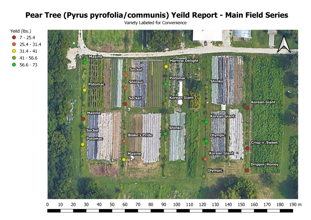
The ability to generate reports and visualization of data collected is the primary output of this project. Beyond typical line graphs or bar charts, the PEAR team is highly interested in geographic information systems (GIS), which enable the presentation and analysis of data layered over a map or satellite images. Below is a report of 2019 pear yields in EarthDance’s Main Field. The legend on the left indicates the categories of yield ranges from lowest to highest harvested that year in pounds (lbs).
This same format can be used for visualization of diseases or pests across the entire orchard or a particular field used in the yield report example. With additional measuring devices, visual observations recorded with the PEAR app can be compared with total sunlight, rainfall, or humidity. One future output of this project could be an analysis of micro-climate conditions (e.g., temperature, humidity, soil moisture) and rates of disease among trees. System level analysis such as this, could provide growers with detailed, valuable information regarding their specific site and inform orchard planning to pursue increased efficiency and tree longevity.
Educational & Outreach Activities
Participation summary:
On-farm demonstrations allowed the team to present the concept behind the project as well as the needs the application and research set out to address. Each demonstration started with a presentation followed up with a field walk through the orchard. During the field walks visitors were led through the process of tree observation to identify any pressures from disease or pests and then shown the steps of how to log findings in the application; scan the QR code, input findings, validate entry, save record.
The tour presented the same information to guests without the hands-on demonstration. While walking the orchard, the project team discussed with guests the importance of fruit tree research in the lower-Midwest and the need for increased local fruit production. A favorite topic during these tours and demonstrations is the pawpaw; typically guests are not aware of this native fruit. Increasing awareness of this delicious native is a perfect intersection of the PEAR application efforts and supporting local fruit production.
Project outreach and communication efforts utilized several different outlets. A project summary and announcements were published in the EarthDance monthly newsletter shared with over 9,000 farm supporters, posts on social media highlighted the work being done and shared event details. Finally, direct email was used to invite regional growers, project supporters, and members from other environmental and agricultural organizations. Thirty people attended the on farm demonstrations and tour. Additionally, a documentary film crew collected introductory video and interviews for a pilot concept about local food efforts. The PEAR application was featured and discussed in this content collection, however at the time of this report the status of the episode is unknown. This is just one example that highlights the excitement and enthusiasm people expressed for this project.
Future communication could include annual reports of the orchard health, changes to the research project as it enters new phases of expansion, and with enough time and input, trends could emerge from the data collected. This information would be included in monthly EarthDance newsletters and social media reports.
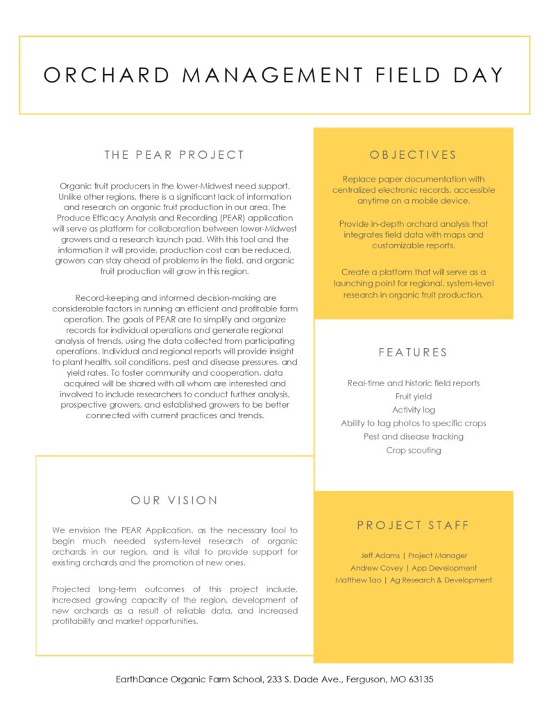
The outreach email inviting attendees to the field day included the project summary in a one-sheet below.
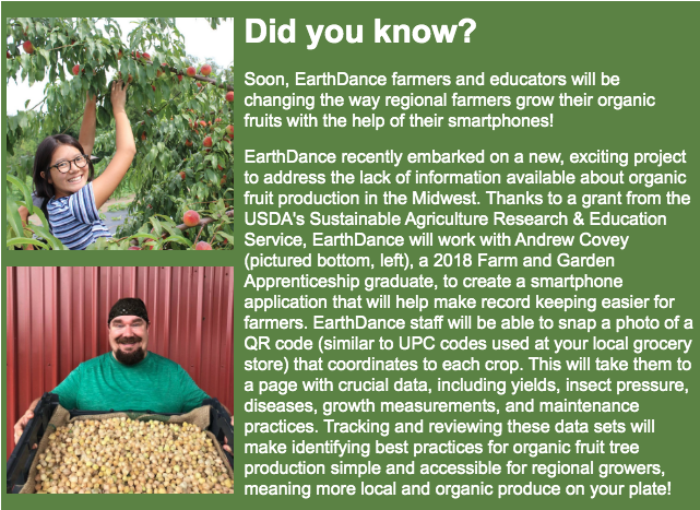
Below is an excerpt from EarthDance's March 2019 newsletter which announced the commencement of PEAR project in collaboration with SARE.
Learning Outcomes
Early steps in the project which included a total inventory of the orchard immediately highlighted erroneous records that had not been updated for a few years. Examples included: dead trees that had not been removed from the inventory, mislabeled trees, and new trees that had been planted but not added. Additionally, the initial inventory allowed the team to identify and tag each tree that required significant maintenance or care. Within the first two months of the project, the records management objective was the primary focus and a rudimentary version of the application was in place. Improved records management was an early advantage of this project and developed into the identification of orchard care needs.
As the growing season began in earnest, it became clear that the plan for the farmers to utilize the application during field walks was not an effective approach to achieve the projects data collection goals or an efficient use of the limited time available to the farmers. This was a significant disadvantage discovered early into the data collection phase of the project. As a market farm, the amount of produce and fruits being cared for by the farmers made it unrealistic for them to commit time to orchard observation and data collection. For this reason it is recommended that future implementation of this project, or projects similar, should be focused specifically on orchards, or market gardens that have the capacity to take on regular, and sometimes lengthy, observations.
Future expansions or adaptations of this project should be regionally focused. Currently the application is only in use at EarthDance but for the full research potential of the project to be realized a network of orchards is needed. In order to collect an accurate and robust data set, fruit producers interested in this project should establish regional partnerships.


