Final report for GNE19-218
Project Information
Managing the agricultural inputs of a functional small farm is often not as complicated as maintaining economic viability. It is imperative for farmers to monitor their net returns, which are directly affected by the costs and efficiency of labor, which can be complicated to manage. In this study, inexpensive, wearable GPS devices were evaluated as a potential system to acquire labor data on a small farm. Data acquired through tracking the movements of farm workers with Garmin Instinct® watches were analyzed in ArcGIS. The spatial analysis revealed discrepancies between labor times tracked with an analogue reference system and the GPS devices. Rates of error ranged from 0 to 83% and varied by crop and size of field. This can potentially limit their viability in tracking labor on small farms where error may result in significant inaccuracies in the acquired data. A labor tracking system that is used at a suitable scale, or utilizes technology, that circumvents the limitations of contemporary GPS and is integrated into a farm management information system in such a manner that removes the need for specialized spatial analysis skills could be a useful decision-making tool for vegetable farmers.
Study Objective:
1. Determine the viability of a relatively inexpensive system for monitoring farm labor expenses, using Garmin Instinct® watches.
Organic farms often have diverse enterprises that provide economic benefits by expanding markets and reducing risk (Kremen and Miles 2012). Diversification presents challenges, including opportunity costs if less lucrative enterprises are chosen in lieu of more profitable ones, or if significant inefficiencies are present therein (Carsan et al. 2014). Farmers may not be aware of the real-time elements that contribute to profit, and expenses associated with individual enterprises because performance is highly context specific (Rosa-Schleich et al. 2019). Ideally, farmers would monitor each of their ventures, adapting them through changes in pricing or the reduction of expenses (Wiswall 2009). Such nimble decision making requires access to reliable and timely data regarding farm assets, including inputs such as fertility, seed, equipment use and labor.
Historically, farmers have recorded and reviewed budget information using pen and paper crop journals, often with spreadsheet software. Today, there are a vast array of digital farm management information systems (FMIS), including dozens designed specifically for diversified fruit and vegetable producers; examples include Granular® (Corteva Agriscience, Wilington, DE, USA), EasyFarm® (Vertical Solutions, Minot, ND, USA), Croptracker® (DragonFly Inc, Kingston, Ontario, Canada), and FarmOS® (farmos.org) that allow farmers to track many assets across their farms. While these tools effectively manage data, expenses and revenue must be manually entered, a task that often is relegated to a “rainy day.”
Tracking labor expenses can be especially complicated. Analyzing payroll records (Wiswall 2009) is straightforward, but it is difficult to differentiate between time spent on disparate farm tasks. Moreover, these records do not allow farm managers to understand inefficiencies in a timely manner. Crop-specific labor is also complicated because activities are temporally sporadic and can span months or even years of work.
Wearable GPS devices, including watches, pendants, and bracelets, are routinely used to locate and monitor individuals, and also for post-hoc tracking of activities (Stopher et al. 2018). GPS tracking has been used to better understand the effects on physical movement of cognitive disorders due to multiple sclerosis (MS) and advanced age (Neven et al. 2012; Williamson et al. 2017). These studies suggest that wearable GPS devices are a viable method of spatial data collection while remaining non-hindering to the wearer. Given this, we speculated that wearable GPS devices could be used to track the time employees spent at particular farm locations throughout the day.
Our objective specifically was to determine the viability of a relatively inexpensive system for monitoring farm labor expenses, using Garmin Instinct® watches. We hypothesized that the use of commercially available GPS technologies would be an improvement upon typical farm labor tracking methods by acquiring farm asset information more efficiently and could potentially be integrated into existing farm management information systems.
Cooperators
- (Researcher)
- (Researcher)
Research
A field experiment was conducted at the University of Maine Rogers Farm (44.93°N, 68.70°W) during the summer of 2020. A “model farm” was established across two fields (54 x 20 m and 70 x 17 m, respectively); soils were a Nicholville very fine sandy loam (coarse-silty, isotic, frigid Aquic Haplorthods). Initial tillage was done with a tandem off-offset disk to control winter annual weeds. Nutri-wave™ 4-1-2 organic fertilizer (Envirem Organics, Fredericton, NB, Canada) was applied at 50.4 kg ha-1 and incorporated using a Perfecta Harrow mounted to a John Deere 6300. Feather meal (13-0-0) was applied by hand at 39.2 kg ha-1 to individual carrot beds and incorporated by hand. Immediately prior to crop planting, the study area was rototilled and culti-packed to firm the beds. Seeds were sourced from Johnny’s Selected Seeds (Winslow, ME). In field A, beds 152 cm on center were established and sown to eight different crops with a Jang Seeder (Jang Automation Co., LTD, Chungcheongbuk-Do, Korea) and, in field B, three beds were prepared similarly and sown to beet (Chioggia Guardsmark) with a Wizard vacuum seeder (Sutton Ag Enterprises Inc., Salinas, CA, USA). To represent a small, diversified vegetable farming operation, nine crops were sown, maintained, and harvested (Table 1).
Labor inputs included planting, fertilizer applications, hand pulling weeds, weeding with scuffle hoes, weeding with wheelhoes, and harvesting. All labor inputs were tracked using Garmin Instinct® watches (Garmin Ltd., Olathe, Kansas, USA). The Garmin Instinct® is a single frequency device, capable of utilizing three global positioning systems – GPS, GLONASS, and GALILEO – which we believed made it well suited to tracking labor in rural locations. The Garmin Instinct® has a noted error margin of about 3 m, typical of commercially available navigational devices (Uradzinki and Bakuła 2020). Therefore, buffer beds of each crop were also planted to minimize overlap in GPS data collection (Figure 1). The GPS tracked data were compared to a reference system in which paper records were kept throughout the season and the data was later uploaded to the online FarmOS® software.
Prior to beginning any farm tasks, participants were asked to note the name of the task and start time in a provided notebook before engaging the GPS function on a provided watch and allowing it to acquire the position, via satellite connectivity. Participants were required to wear the watch, or have it on their person, before engaging the GPS tracking mode. To increase the accuracy of the position data logging, watches were set to record a data point every second, regardless of changes in direction or speed. While the watch tracked their movements, participants were asked not to leave the designated crop area, which included only the bed in which the crop was being grown and the wheel tracks on either side which were used as walking pathways. Upon the completion of each farm task, participants disengaged the GPS and noted the end time for the event.
Data acquired by tracking the spatial movements of workers within the farm, using worker-worn personal GPS receivers, was overlayed onto the time-stamped location data output on a georeferenced, digitized map delineating the different crops and other work areas within the farm (Figure 2). Prior to any analysis, the location of the corners of each crop area were precisely georeferenced using a NET-G5 GNSS reference receiver and an FC-5000 field controller, capable of referencing all GNSS constellations using GPS, GLONASS, and GALILEO (Topcon Electronics, Livermore, CA, USA). The spatial boundaries of individual crops within the farm were defined as separate polygons in a GIS. The intersection of each worker’s location history, stored as points, with the crop polygons was calculated to determine the time spent in each crop. Spatial data manipulation was conducted in ArcGIS (ESRI, Redlands, CA, USA). Labor expenditures within different arenas of farm operations were calculated by quantifying time spent by individual workers on specific activities and multiplying by the relevant labor rates (Table 1). Labor rates were based on farm worker wage estimates by the USDA (USDA 2019).
|
Test crop |
Cropped area (m2) |
Tasks tracked |
Cumulative labor time (min) |
Total labor cost ($) |
|
Arugula |
33.90 |
Planting, weeding, harvesting |
22.95 |
5.42 |
|
Bean |
248.05 |
Planting, weeding |
163.11 |
38.52 |
|
Beets |
90.58 |
Weeding, harvesting |
105.48 |
24.91 |
|
Broccoli |
41.80 |
Planting, weeding, row covering, harvesting |
63.28 |
14.95 |
|
Carrot |
48.77 |
Planting, weeding, fertilizing, harvesting |
76.26 |
18.01 |
|
Chard |
82.68 |
Planting, weeding, harvesting |
49.53 |
11.70 |
|
Kale |
41.80 |
Planting, weeding, row covering, harvesting |
122.05 |
28.82 |
|
Kohlrabi |
18.58 |
Planting, weeding, row covering, harvesting |
35.05 |
8.28 |
|
Radish |
64.10 |
Planting, weeding, row covering, harvesting |
68.91 |
16.28 |
Table 1. Time spent within the boundaries of each crop and the associated cost of labor, as recorded with the paper reference.
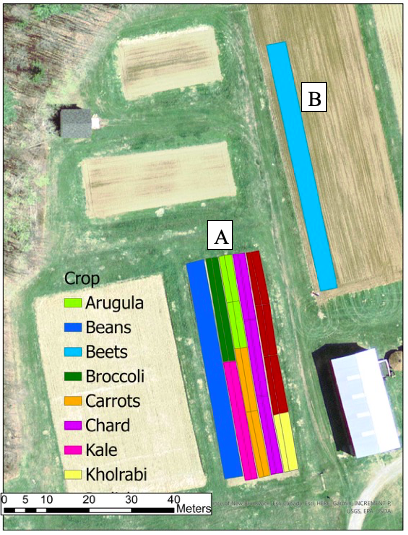
Figure 1. Georeferenced, digitized map of fields A and B, depicting separate polygons for each included test crop, produced from surveyed points, projected with Maine East Mercator NAD (2011 realization) in U.S. survey foot.
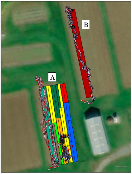
Figure 2. Digitized map of fields A and B overlayed with time-stamped location data acquired with Garmin Instinct® watches for beets, beans, and carrots.
A total of 11.9 hours were recorded using the reference system while conducting farm tasks across all crops grown. Crops exhibited a wide range of labor requirements, from 22 minutes to 2.7 hours of cumulative labor time and labor expenditures that ranged from $5.42 for arugula to $38.52 for beans, respectively. Cumulative labor times were similar to labor rates recorded in vegetable field operations for previous studies (Sørensen et al. 2005). Pen and paper records for each of the 83 farm tasks conducted over the season required approximately 3 minutes to be transferred to farmOS®, resulting in a cumulative 4.15 hours spent digitizing data for the reference system.
While data collected with the GPS receivers were correlated with the reference system (r = 0.9642, P = 0.0001), there was an associated average error rate of 37% across all crops (Figure 3). Rates of error, by crop, ranged from zero for beets to 83% for beans. The noted rates of error may be an inherent problem with using commercially available GPS devices which primarily utilize frequencies from only one satellite constellation at a time. This can potentially limit their viability in tracking labor on small farms where error may result in significant inaccuracies in the acquired data.
Despite this error, the Garmin Instinct® may be a viable GPS receiver on somewhat larger farms where field sizes are proportionally larger than the radius of error. This was apparent in the absence of any deviation from labor tracked with watches and the reference system in the beet plot (Figure 3) where the cropped area was roughly five times that of smaller areas in field A. However, the risk of overlapping labor tracks remains an issue if cropped areas are directly adjacent, as demonstrated by the considerable level of error associated with the relatively large area designated for beans. Alternatively, differentiation through the timing of the crops for which labor is tracked may be a useful method to avoid overlap in GPS tracks. For instance, if a farmer were to plant a crop that is typically harvested later in the season and requires minimal labor inputs earlier in the season directly adjacent to another crop with contrasting labor needs, it would be possible to distinguish GPS pathways and subsequently calculate labor expenditures accurately.
There is potential for the further development of global navigation satellite systems (GNSS) to obviate these limitations as satellite constellations transmitting signals on two or more frequencies become more common (Chen and Chang 2020). Combining satellite constellations, essentially increases the number of visible satellites and therefore improves the precision of positioning systems (Hou et al. 2021). For nearly 20 years, only GPS and GLONASS transmitted dual frequency signals (Johnston et al. 2017), and recently, the use of three or more frequency signal transmitting systems have been shown to provide more robust positioning observations (Zeng et al. 2021). However, while GNSS technology has developed significantly in recent decades, multiple frequency systems have not been available in commercial grade devices, such as smartphones, tablets, or portable navigation systems. Today, dual frequency systems are available in commercially available devices, such as the Mi 8 (Xiaomi Corporation, Beijing, China), the first smartphone capable of utilizing dual frequency technology, and have proven to be viable (Montenbruck et al. 2019). Given these developments, there is potential for this system to be adapted to FMIS which already utilize smartphone applications such as FarmOS Field Kit®.
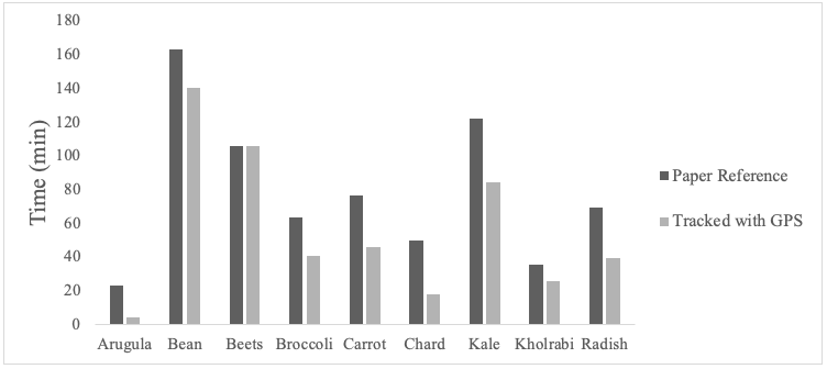
Figure 3. Time spent within the boundaries of each crop bed, as recorded with the paper reference and tracked by Garmin Instinct® watches.
Tracking on-farm assets can be difficult and expensive, making it less likely for farmers to do, and while an FMIS can facilitate data storage and description, data acquisition for labor is often challenging. A labor tracking system that is used at a suitable scale, or utilizes technology, that circumvents the limitations of contemporary GPS and is integrated into an FMIS in such a manner that removes the need for specialized spatial analysis skills could be a useful decision-making tool for vegetable farmers.
References:
- Carsan S, Stroebel A, Dawson I, Kindt R, Mbow C, Mowo J, Jamnasdass R. (2014). Can agroforestry option values improve the functioning of drivers of agricultural intensification in Africa? Curr. Opin. Environ. Sustain. 6: 35-40.
- Chen C, Chang G. (2020). PPPLib: An open-source software for precise point positioning using GPS, BeiDou, Galileo, GLONASS, and QZSS with multi-frequency observations. GPS Solutions. 25:1-7.
- Fountas S, carli G, Sørensen C, Tsiroulos Z, Cavalaris C, Vatsanidou A, Liakos B, Canavari M, Wiebensohn J, Tisserye B. (2015). Farm management information systems: Current situation and future perspectives. Comput. Electron. Agric. 115: 40-50.
- Hoppe RA, Macdonald JM, Korb P. (2010). Small Farms in the United States: Persistence Under Pressure. USDA Economic Information Bulletin Number 63.
- Hou P, Zhang B, Yuan Y. (2021). Combined GPS+BDS instantaneous single- and dual-frequency RTK positioning: stochastic modelling and performance assessment. Journal of Spatial Science. 66: 3-26.
- Johnston G, Riddell A, Hausler G. (2017). The international GNSS service, in Springer Handbook of Global Navigation Satellite Systems, Springer, Cham, 2017, pp. 967-982.
- Kremen C, Miles A. (2012). Ecosystem services in biologically diversified versus conventional farming systems: Benefits, externalities, and trade-offs. Ecology and Society. 17: 40.
- Lin B. (2011). Resilience in agriculture through crop diversification: Adaptative management for environmental change. Bio Science. 61: 183-193.
- Mchugh S, Yarmey K. (2014). Near Field Communication: Recent Developments and Library Implications. Synthesis Lectures on Emerging Trends in Librarianship. 1: 1-93.
- Montenbruck O, Hauschild A, Langley R, Siemes C. (2019). CASSIOPE orbit and attitude determination using commercial off-the-shelf GPS recievers. GPS Solutions. 23: 1-12.
- Neven A, Janssens D, Alders G, Wets G, Wijmeersch BV, Feys P. (2013). Documenting outdoor activity and travel behaviour in persons with neurological conditions using travel diaries and GPS tracking technology: A pilot study in multiple sclerosis. Disability and Rehabilitation. 35: 1718-1725.
- Reynolds, K. (2015). Small Farm Economic Viability. University of Santa Cruz, Center for Agroecology and Sustainable Food Systems.
- Rosa-Schleich J, Loos J, Mußhoff O, Tscharntke T. (2019). Ecological-economic trade-offs of Diversified Farming Systems – A review. Ecological Economics.160: 251-263.
- Ruiz-Garcia L, Lunadei L. (2011). The role of RFID in agriculture: Applications, limitations and challenges. Computers and Electronics in Agriculture. 79: 42-50.
- Sørensen C, Madsen N, Jacobsen B. (2005). Organic farming scenarios: Operational analysis and costs of implementing innovative technologies. Biosystems Engineering. 91: 127-137.
- Stopher P, Daigler V, Griffith S. (2018). Smartphone app versus GPS Logger: A comparative study. Transportation Research Procedia. 32: 135-145.
- Uradzinski M, Bakuła M. (2020). Assessment of static positioning accuracy using low-cost smartphone GPS devices for geodetic survey points’ determination and monitoring. Appl. Sci. 10: 1-22.
- USDA Economic Research Service (ERS). Farm resources, income, and expenses. (2019). Retrieved from https://www.ers.usda.gov/
- Watson H, Caroll A, Mann R. (1991). Information systems for management: A book of readings. Business Publications, 3rd Edition.
- Williamson B, Aplin T, Jonge DD, Goyne M. (2017). Tracking down a solution: Exploring the acceptability and value of wearable GPS devices for older persons, individuals with a disability and their support persons. Disability and Rehabilitation: Assistive Technology. 12: 822-831.
- Wiswall R. (2009). The Organic Farmer's Business Handbook. White River Junction, VT: Chelsea Green Publishing.
- Zeng T, Sui L, Ruan R, Jia X, Feng L, Xiao G. (2021). GPS triple-frequency undifferenced and uncombined precise orbit determination with the consideration of receiver time-variant bias. Measurement. 169.
- Zentner R, Wall D, Nagy C, Smith E, Young D, Miller P, Campbell C, McConkey B, Brandt S, Lafond G, Johnston A, Derksen D. (2002). Economics of crop diversification and soil tillage opportunities in the Canadian prairies. Agronomy Journal. 94: 216-230.
Education & outreach activities and participation summary
Participation summary:
After completing the analysis for this project, we met virtually with the developers of FarmOS® to discuss the viability of integrating GPS labor tracking as a module to their mobile application, FarmOS Field Kit®. Although the system would still need to be refined into a functional algorithm before being adapted to the software, there is strong enthusiasm for a system such as this to monitor on-farm labor among software developers and users. The enthusiasm surrounding the concept evaluated in this study is further exhibited in a news article published in Lancaster Farming, "UMaine Project to use RFID tags & GPS technology to track farm labor efficiency."
Project Outcomes
Organic farmers represent a wealth of knowledge regarding the production of fruits, vegetables, and livestock. However, remaining economically viable can often be the most difficult part of an enterprise. The role of technology designed for farm data management is growing and will continue to be an important component of agriculture in the future. The future sustainability of farms of all sizes will depend on their abilities to adapt to constantly developing technologies. Providing farmers with systems that can facilitate data collection and analysis that can be used to inform data-driven management decisions may offer them an edge in increasingly competitive markets. It is important that these systems do not hinder farmers, making research into the automation of the data collection portion of these systems imperative. Additionally, these systems must be cost effective. To these ends, the inexpensive technologies determined in this project to be potentially viable at suitable scales can inform future research.
Through this study and our consultation with the developers of FarmOS®, we have noted several insights that may be beneficial for future research endeavors. To accomplish creating an automated system to collect data describing the time spent in a particular location on a farm, to replace the need for manual data entry, it might be useful to approach the problem in four steps: 1) creating digitized maps for areas of interest, 2) tracking the locations of workers and other assets, 3) analyzing the movement data with areas of interest, and 4) recording and reporting the results.
Our project provides useful methods to accomplish the first problem and FarmOS® is capable of readily utilizing and creating digitized maps. Moreover, as FarmOS®, and other similar softwares, are designed with the fourth problem in mind, recording and reporting labor data will not be a problem if it is accurately collected. We believe that the second and third problems will be the most substantial moving forward. As we state in the report, the degree of accuracy associated with GPS devices such as Garmin watches may not make them the optimal choice in receivers. Further research into devices capable of utilizing multiple GNSS frequencies, as well as other technologies that were beyond the financial scope of this study, may provide insights into the development of future labor tracking systems. Finally, upon such a time that a system is created that can automatically and accurately collect labor movement data, skills in coding will be paramount as this system would need to be codified into a form readily able to be integrated into new or existing farm management information softwares.