Final report for LNC21-445
Project Information
Riparian systems are essential to maintaining key ecosystem services such as water regulation, biodiversity, wildlife habitat, and forage for grazing livestock. In some instances, removal of natural hydrological features (beaver dams) and heavy livestock utilization has caused degradation, stream bank erosion, channel incisions, and head-cutting. The result is soil erosion, poor water quality, loss of wildlife habitat, and reduced grassland economic potential. Recent research has been conducted on the use of low-cost, low-tech tools (LCLTT) that mimic beaver dams as a method for restoring riparian health. LCLTT such as beaver dam analogs (BDAs) have successfully been implemented in the Western U.S. to restore ecosystem services within degraded small and ephemeral streams and wet meadows. These earthen, natural material structures slow and disperse water, dissipate energy, and restore natural floodplains, improving soil water retention and increasing riparian vegetation. Despite benefits, LCLTT have not been adopted in North Central Region (NCR) grasslands due to lack of knowledge, producer apprehension and skepticism surrounding beavers, and a lack of trained technical experts and producer peer mentors. Thus, without research, extension, and educational programs to teach producers about the benefits of LCLTT and their role in riparian and rangeland health, riparian systems within the NCR will likely continue to see a decline in both environmental quality and profitability.
For this project our objectives are to 1) research the impact of LCLTT on soil moisture, riparian vegetation, and biomass production and 2) develop on-site demonstrations, trainings, and workshops for producers and technical experts on the implementation of LCLTT to improve hydrological function. We will specifically research the impact and efficacy of LCLTT on forage production, plant community composition, and soil moisture at a research field station and on producer ranches. We will test, demonstrate, and monitor practices in local settings with producers, allowing them to implement their grazing plans in conjunction with our work. Our inter-disciplinary team (range ecology and management and riparian health ecology) will work with producer participants to host field tours and workshops throughout the project to highlight successes and any limitations that arise. This will allow for flowing conversations to occur between producers and technical experts about potential adoption of LCLTT and will therefore create a holistic understanding of implementing LCLTT in the NCR. Overall, our long-term goal is to improve watershed health at landscape scales in grassland ecosystems and educate producers about the benefits of LCLTT.
Research:
- Research LCLTT’s impact on forage production, plant community composition, and soil moisture.
Extension:
- Implement LCLTT on cooperating ranches and at a research field station.
- Teach technical experts and producers about LCLTT through trainings and workshops.
Learning Outcomes:
- Learn how to deploy LCLTT on public and private lands.
- Educate producers on riparian health.
Action Outcomes:
- Technical experts construct LCLTT on public lands; assist producers on private lands.
- Producers more widely accept LCLTT and implement LCTT on their operations.
System Outcomes:
- Improved riparian health means less soil erosion, improved wildlife habitat and ranch profitability.
This progress report includes activities from November 1, 2021 to December 31, 2022. Below we provide an overview of activities that occurred during Year 1 of our grant. We have had great success so far, and are excited to see where this project is at the end of the grant's life.
Cooperators
Research
Our hypothesis for this research is that LCLTT structures such as BDAs will increase the following: available soil moisture, forage production, and the prevalence of wetland and facultative wetland plant species such as prairie cordgrass near the stream.
<><><><><><><><><><><><><><><><><><>
<><><><><><><><><><><><><><><><><><>
<><>General Approach<><>
This project builds upon a pilot project implemented by TNC in 2020 to restore riparian health in prairie streams in western South Dakota using LCLTT such as BDAs. The overall goals of our project are to increase awareness and adoption of riparian restoration programs by 1) providing critical research on LCLTT and impacts on forage production, plant community composition, and soil moisture and 2) conducting outreach and extension activities for producers on site selection, materials, and construction techniques for implementing LCLTT restoration techniques on their operation.
Intended Audience: The intended audience for this proposal includes technical experts (federal, state, NGO, university partners) and livestock producers within the NCR.
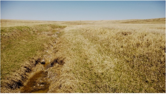
Site Selection: Research for this project will take place on five producer ranches as well as the SDSU Cottonwood Field Station (CFS) located near Philip, SD. The CFS is used primarily for livestock grazing and lies within a Northern Mixed Grass Prairie ecosystem. Topography of the station is gently sloping with long, rolling hills and relatively flat-topped ridges. The CFS lies within the Pierre Shale Plains major land resource area (MLRA) (MLRA 60A). Soils of the mixed-grass prairie research pastures are predominantly Kyle and Pierre clays developed from the Pierre formation (shale). Cottonwood Creek is an intermittent stream within the Bad River watershed and meanders through approximately 3 miles of the CFS boundary across 4 pastures. Long-term (>40 years) livestock grazing within pastures containing Cottonwood Creek has resulted in stream bank erosion, channel incision, and head-cutting, impairing riparian function throughout the property.
In 2019, TNC developed a web-based tool (missouriheadwaterstool.org) to foster collaboration at a watershed scale to enhance riparian health efforts among partners in Western South Dakota, North Dakota, Montana, and Wyoming. The tool aggregates spatial datasets such as ecological sites, rangeland potential, hydrologic data, elevation, slope, and satellite imagery to help identify intactness, erosion potential, drought vulnerability, and resilience of riparian areas. This tool will be used to identify riparian areas on cooperator ranches with the highest potential for enhancement using LCLTT. Cooperator ranches will be located within MLRA 60A to minimize differences in soil type and land potential allowing for comparison of results between sites. Data collection is the same for Research and Demonstration aspects of this project, and for simplicity, is described only once.
1. Research
Hypothesis: LCLTT will increase riparian vegetation, biomass production, and soil moisture content compared to untreated stream reaches.
Restoration Treatments: Six stream reaches suitable for riparian restoration will be identified at each site (CFS and the 5 producer ranches). Stream reaches will be randomly allocated into a control (no restoration) and a LCLTT. This will be a complete randomized block design with producer ranches as blocks and reaches as the experimental unit.
Vegetation Data Collection: Along each of the 6 stream reaches per site, three vegetation transects will be established and measured prior to the LCLTT implementation to collect baseline vegetation data. Vegetation transects (50 m) will be established perpendicular to the stream channel and span the valley bottom width. Along each transect, a pin flag will be dropped every 50cm and all plant species that contact the pin flag will be recorded. Vegetation transects will be measured in the summer of Years 1, 2, and 3. Data from the plant transects will be used to analyze species composition within riparian areas to compute similarity indexes between current vegetation composition and historical states as defined by ecological site descriptions. Data will be statistically analyzed for treatment effects within and between years.
Vegetation biomass will be evaluated using 0.25 m2 permanent plots; 3 plots will be randomly located in each stream reach segment within the floodplain area. Livestock exclusion cages will be used to protect plot vegetation from grazing. Plots will be evaluated once each growing season in Years 1, 2, and 3 during peak biomass production (July-August). Data collected in each plot will include: 1) a complete species list, 2) percent cover for each species, 3) height of each species, and 4) non-destructive biomass estimates of each species using a double sampling technique. Biomass composition (based on biomass and cover), species richness, and a Shannon-Weiner diversity index will be derived from the plot data. Response variables will be statistically analyzed for treatment effects within and between years.
Within each stream reach, two photo monitoring points will be established at opposite ends of the reach. Digital photographs will be taken at each photo point during biomass sampling. Photo monitoring is a valuable qualitative tool for documenting current conditions of a site as well as tracking changes due to treatment or management differences. Photo point data will be used for demonstration and extension materials.
Soil Moisture Data Collection: State-of-the-art sensors for soil water content, soil temperature, and soil electrical conductivity will be used to determine seepage of soil moisture at 0, 6, 12, and 18-inch depths at two locations (1 LCLIT and 1 Control) at each site. Soil moisture will be collected using probes for measuring soil volumetric water content (e.g. HOBOnet Multi-Depth Soil Moisture Sensor, Bourne, MA). Soil probes will be installed 10 m from the edge of the stream channel within the flood plain. Once installed, the sensors will record measurements at 15-minute time intervals for the entire study period. Sensors will be connected to a wireless network to allow data to be received and downloaded from a central location. Differences in soil moisture will be statistically analyzed for treatment effects within and between years.
<><><><><><><><><><><><><><><><><><>
<><><><><><><><><><><><><><><><><><>
<><><><><><><><><><><><><><><><><><>
<><><><><><><><><><><><><><><><><><>
<><>Additional research methods as of grant completion, 11/30/2025<><>
Dawson Uhl was hired as an additional M.S. graduate student on the project. He was supported in part by this SARE project, as well as a USDA AFRI grant with PI Dr. Jameson Brennan. Dawson’s objective was originally to understand how stakeholders view riparian restoration; after several discussions, we decided to seize on the opportunity of using virtual fence (VF) in the riparian area at the SDSU Cottonwood Field Station. This decision was informed by interest by both landowners and partner organizations (NGOs such as The Nature Conservancy, federal agencies such as U.S. Forest Service and NRCS) on how virtual fencing can be leveraged in this management scenario.
The methods used in the virtual fence riparian project are described in brief below. Note that we used the Gallagher eShepherdTM VF system for this research project (Figure 1).

The study was established using three pastures at the SDSU Cottonwood Field Station, in which each of the three pastures contain a riparian zone along Cottonwood Creek. The study utilized Angus heifers (n = 40; 357.3 ± 35.9 kg). Pasture boundaries and virtual fence locations were digitized using georeferenced imagery from Gallagher (Figure 2). Virtual fence polygons included an exclusion zone encompassing most of the riparian corridor and an inclusion zone positioned outside pasture boundaries as a precautionary measure in case cattle escape the physical fences.
Cattle were sequentially grazed in the three pastures for 28 days each, with virtual fencing used to manipulate access to riparian areas within each pasture. Within each pasture, cattle were restricted from the riparian exclusion zone for the first 14 days using an active virtual boundary (Figure 3) followed by 14 days of unrestricted access (Figure 4) during which the exclusion boundary was removed. No fence breaches occurred during the study.
Within each pasture, ten cages, five in each zone; n=30 (riparian and upland, delineated using the NRCS Web Soil Survey) were randomly generated, placed and anchored in the ground from May 2025 to October 2025. Around the middle of each month forage clippings were taken from each caged plot using a 0.25 m² quadrat, then these clippings were dried, weighed, and sent to Ward Labs for quality analysis. Each caged plot was randomly generated and labeled within the Avenza Maps mobile application prior to data collection.
After cattle were taken out of each pasture after 28 days, utilization was assessed using the Landscape Appearance Method as described by the National Research Council and Committee on Rangeland Classification (1994). This method provides a practical and qualitative means of estimating grazing intensity based on the visual appearance of vegetation. In each of the three study pastures, ten 50 meter transects were established, five in upland zones and five in riparian zones. A buffer zone of at least 150 meters separated upland and riparian transects to avoid sampling within the transition area. At each sampling point, a 0.25 m² quadrat was placed at one-meter intervals along the transect, yielding 50 sampling frames per transect and 500 total observations per pasture. Each transect was randomly generated and labeled within the Avenza Maps mobile application prior to data collection.
Data collected included forage biomass/quality, utilization, and GPS data from the virtual fence collars.
Research objective: Research LCLTT’s impact on forage production, plant community composition, and soil moisture.
<><><><><><><><><><><><><><><><><><>
<><><><><><><><><><><><><><><><><><>
<><>Research progress as of 12/31/2022<><>
- We hired a Graduate Research Assistant, James Bolyard. James started January 2022. James was born and raised in southwestern Michigan. After spending several years pursuing medical studies, he graduated from Northern Michigan University in 2015 with a B.A. in Environmental Science, whereupon he spent much of the next six years working with AmeriCorps, NGOs, and various Federal agencies as a seasonal employee in several capacities. James comes to this project with extensive working knowledge of LCLTT for riparian restoration and has been a great addition to the project's team.
- We established 4 sites in 2022; the watershed size above sites varies from 12 km2 to 460 km2. The associated Major Land Resource Area (MLRA) is noted.
- BLM1, Upper Battle Creek - MLRA 60A.
- BLM2, Lower Battle Creek - MLRA 60A.
- PRV1, Newell (SD) Producer - MLRA 60A.
- Cottonwood Field Station, South Dakota State University (SDSU) Cottonwood Field Station - MLRA 63 A.
- Several additional producer sites were identified in 2022, but due to limited access (i.e., producer operations are located on "gumbo" - sticky, high clay soils that make it difficult to access the site unless it is dry) we were unable to complete any LCLTT installation. These sites are now priority for the 2023 field season.
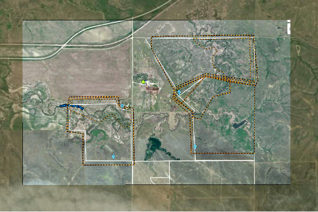
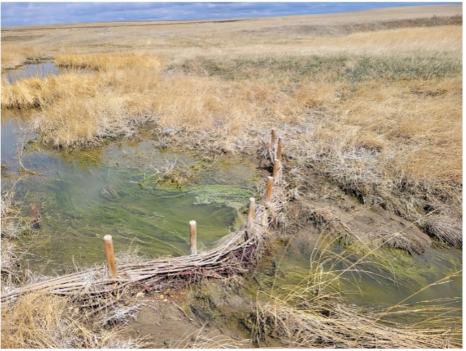
- At each site, the stream width was measured at 20 random points. A stream reach was defined as the stream length equal to 20 average stream widths. Three (3) control reaches were located upstream, and 3 treatment reaches were located downstream. This experimental design was to avoid confounding the effects of the treatment reaches and also included a minimum of 2 reaches as a buffer between the end of the control reaches and the start of the treatment reaches (Figure 1).
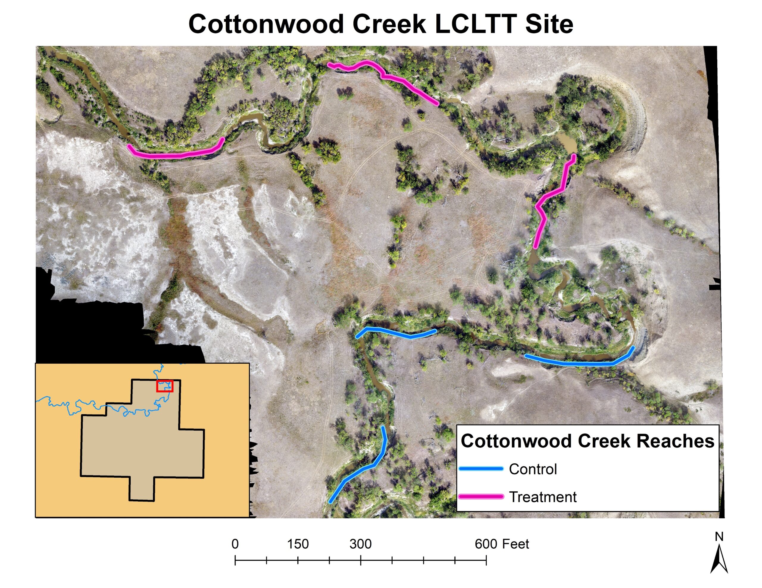
Figure 1, 2022. The SDSU Cottonwood Field Station site. Pink lines indicate treatment stream reaches were structures were installed and blue lines indicate control reaches that lack interference. - 1.08 miles of stream - this includes the stream reach equivalent above each treatment reach that should see at least some improvement from implementation of the structures.
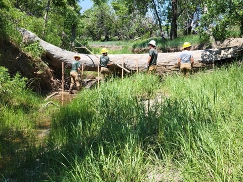
- 28 structures were built across all sites (Figure 2).
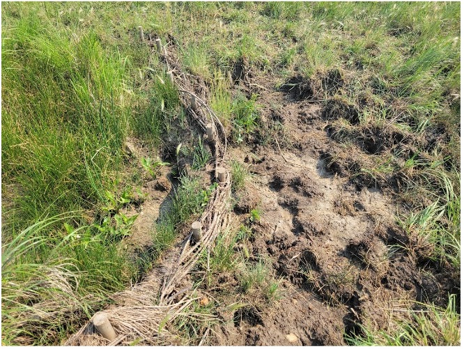
- Structures were installed by AmeriCorps crews in June and July 2022. A mixture of beaver dam analogs (BDAs) and post-assisted log structures (PALs) were used, depending on available materials and site conditions.
- Structures range from <0.3 m to ~ 1.3 m tall and <1 m to >4 m wide.
- Soil moisture probes were installed.
- We are using 45 cm long Hobo Multi-depth soil probes that do soil moisture readings at 0-15 cm, 15-30 cm, and 30-45 cm depths.
- Two probes at each site - 1 probe in a treatment reach and 1 probe in a control reach.
- Readings every 15 min, with broadcast to the cloud every 1 hr.
- Plant community data was collected.
- 50 m transects, 4 transects per reach using the line-point intercept technique
- Non-destructive biomass estimates were collected from 0.5 m2 plots; 3 plots per reach
- We have had notable early success at the SDSU Cottonwood Field Station!!
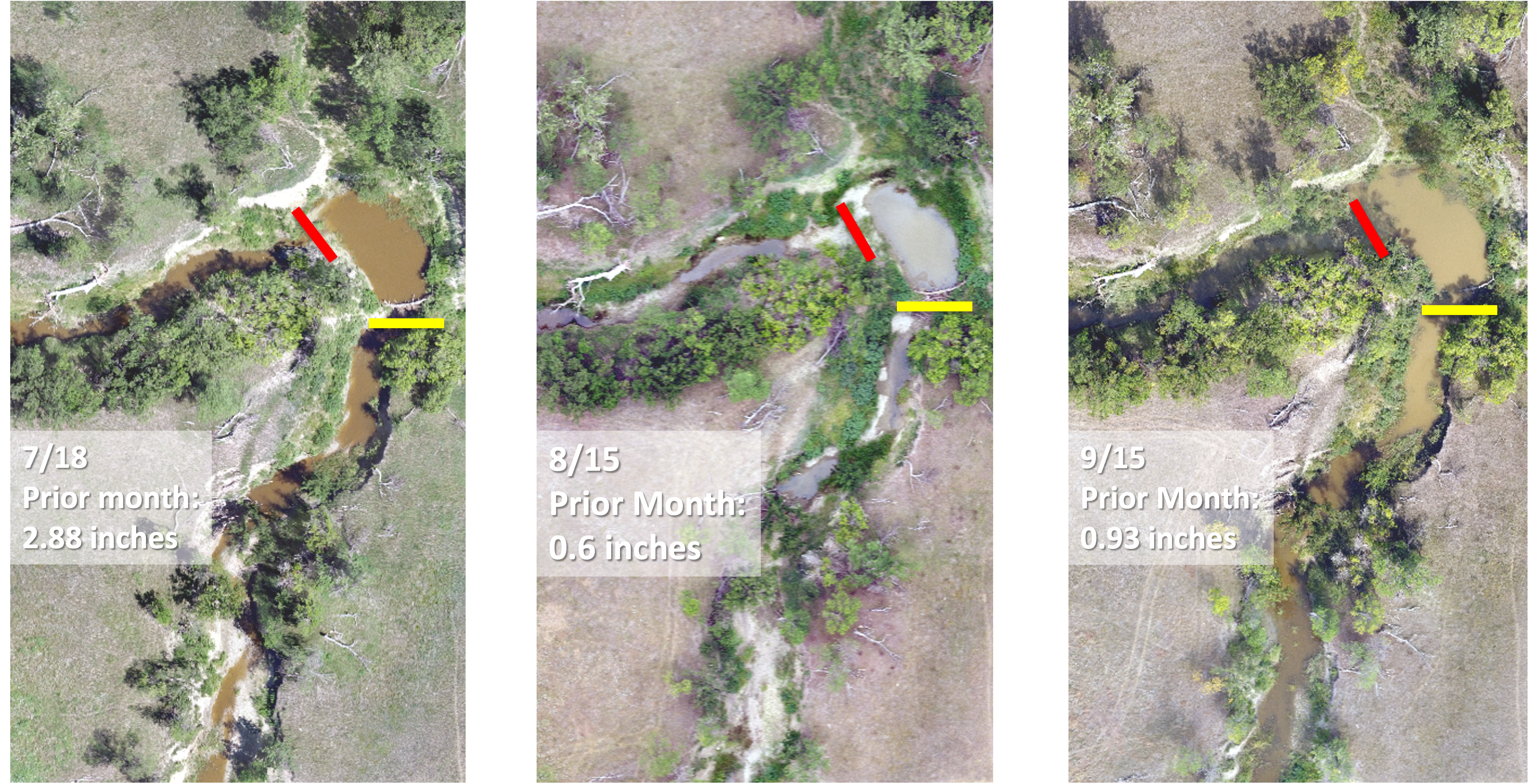
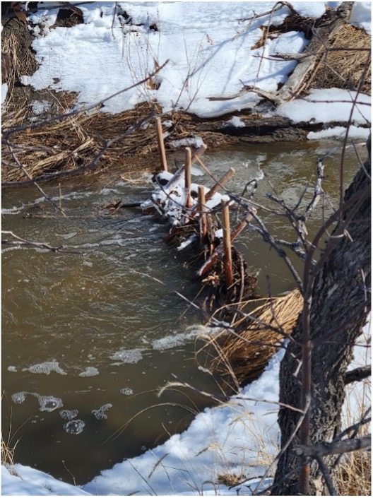
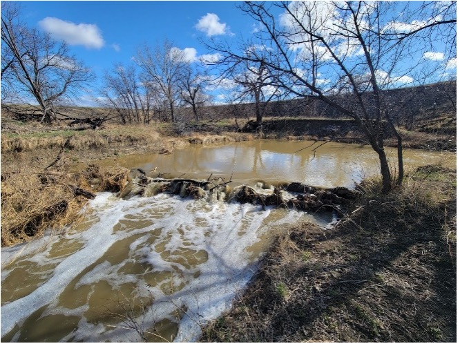
- We installed structures at Cottonwood in July 2022. Figure 3 shows a yellow line, which is where one of our structures was located. We received several inches of rain, causing a few structures - including the one denoted by the yellow line - to blow out. At the same time, we noticed signs of beaver activity on the stream! The beavers reestablished themselves at Cottonwood and built several beaver dams themselves, one of which is noted by the red line in Figure 3 and a close up is provided in Figure 4. Figure 3 clearly demonstrates the benefit of LCLTT such as BDAs in slowing and holding water on the landscape, which is further benefitted by beaver recolonizing the area.
- Of note is that LCLTT structures are not meant to be permanent - instead, they are designed to do exactly what occurred at Cottonwood. The slowing and holding of water on the landscape resulted in water being backed up on Cottonwood Creek further than it has ever been documented before - well into September.
Anticipated research activities in 2023:
- Finish site selection
- Install structures on new sites
- Conduct plant community assessments, including biomass
- Check on soil probe functionality and re-establish connection, if needed
- Structure maintenance on existing sites
<><><><><><><><><><><><><><><><><><>
<><><><><><><><><><><><><><><><><><>
<><>Research progress as of 12/31/2023<><>
Field Work
BLM1
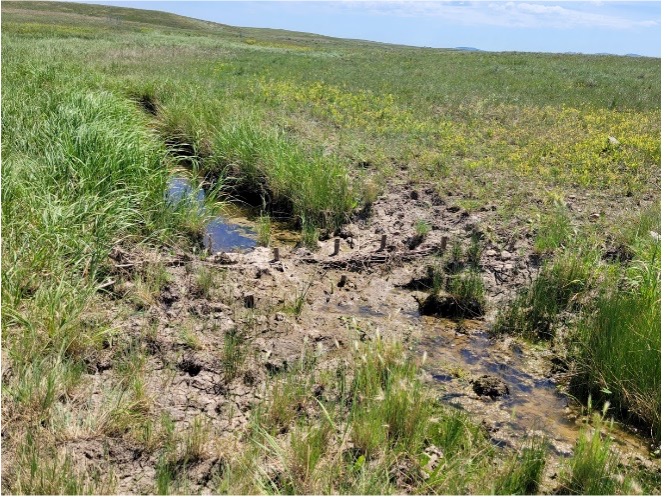
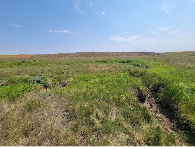
Several of the LCLTT structures at BLM1 suffered damage from high flows and livestock during winter 2022 - spring 2023, but the remaining structures showed considerable signs of success. Surviving structures often had considerable sediment capture on their upstream side, causing stream bed aggradation and improving floodplain connectivity. However, this increased connectivity caused notable erosion issues on side channels, including several headcuts. These issues were addressed by implementing additional LCLTT structures during the planned maintenance in early June 2023, and the structures had largely filled in with sediment within a few weeks, reversing the headcuts and creating a wet meadow area with multiple small pools (Figure 5). While not formally counted, increased numbers of amphibians, reptiles, and nesting/brooding waterfowl were seen in LCLTT treatment areas.
<><><>
BLM2
Structures on the BLM2 site were minimally damaged during winter 2022 - spring 2023. Most structures showed considerable sediment capture and, in less incised locations, considerable improvement in floodplain connectivity (Figure 6). Existing structures were repaired where necessary and expanded either vertically or laterally to continue to improve their results, and new structures were built to capitalize on changes to the stream in the hopes of reconnecting avulsed side channels and meanders. Livestock were present on BLM2 for much of the spring and summer, and as conditions dried animals showed a preference for treatment areas, which maintained surface water longer than untreated areas did. As with BLM1, there was an increased number of amphibians and reptiles on BLM2.
<><><>
Cottonwood Field Station
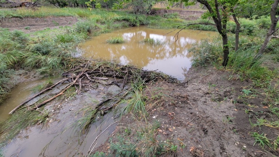
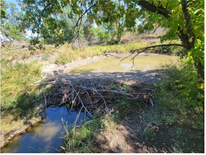
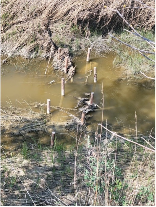
The heavy snows of winter 2022-2023 and the subsequent high flows and debris damaged or destroyed most of the LCLTT structures at Cottonwood Field Station (CFS) (Figure 7) and damaged the naturally occurring beaver dam that was created in one of the treatment areas in 2022. New structures were installed, using coarser heavier materials and lower profile structure designs than were used previously to see if they hold up better to the high flows and debris produced by Cottonwood Creek. A South Dakota State University fisheries biologist did a preliminary survey of the treatment reaches and counted 16 species of fish, including native prairie stream species such as bullhead, sunfish, and redfin shiners, some of which were spawning in the treatment areas. This is a promising indicator of the potential for these areas to serve as production areas and reserves for such species if LCLTT can be used to maintain either continuous surface water or pools that last throughout the year.
By the time LCLTT maintenance and construction could occur, the beavers had largely repaired their dam, and it was decided to have the maintenance crew reinforce the structure with untreated wooden posts (Figure 8). The crew moved piles of flood debris from the bank into the beaver pond, which the beavers then integrated into their dam over the next few days. As water levels in the stream dropped, it became apparent that the dam had captured ~ 1 meter of sediment in the pond above it since its creation, largely filling it. This amount of sediment capture reframes what may be possible with LCLTT on streams of this size and level of incision if structure designs that can hold up to the flows and debris are identified. This could, potentially, make the re-establishment of historic floodplain connectivity a viable option in some areas rather than being limited to creating an inset floodplain.
<><><>
PRV1
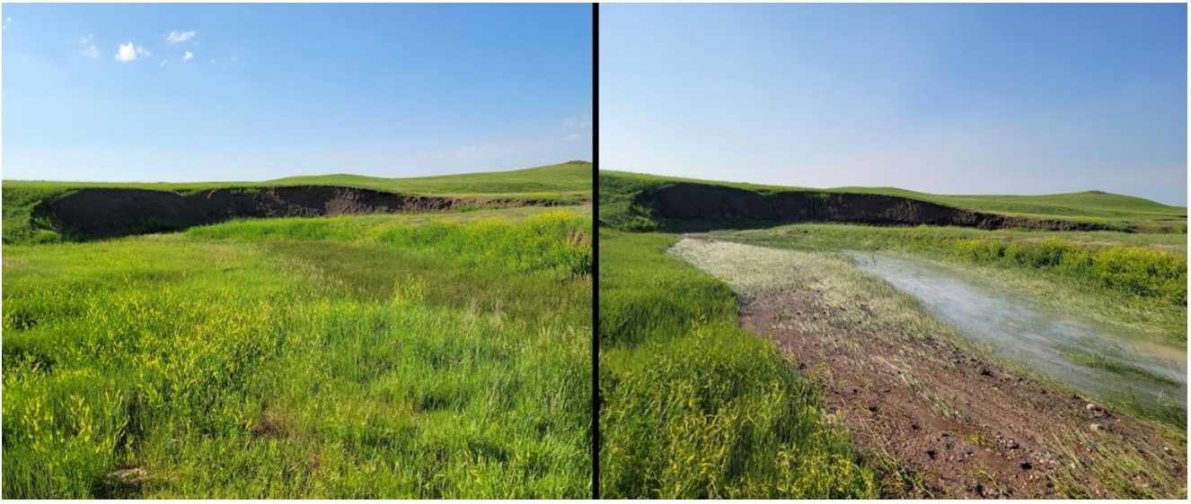
The structures of PRV1 were slightly to moderately damaged during winter 2022-2023 but showed appreciable sediment capture by spring 2024. Before maintenance could be done, a major rain event occurred (>3 inches of rain in 48 hours, according to a local rancher), causing severe flooding. While a few structures were lost in this event, some of the surviving structures filled in with sediment and immediately improved floodplain connectivity, while others caused desired changes to stream and floodplain morphology - which had been anticipated to take years – over the course of a weekend (Figure 9). The remaining structures were repaired and expanded, as needed, and new structures were implemented to take advantage of the changed stream morphology.
<><><>
PRV2
PRV2 is the newly created demonstration site for the project and is located on a private ranch in Butte County, SD (Figure 10). Located on a seasonal to intermittent stream, this site has numerous areas of incision and entrenchment, and it is largely disconnected from its floodplain. LCLTT construction occurred in June of 2023. A wider variety of structures were used on this site compared to others, including wicker weirs, post vanes, and bank-attached PALS. Within weeks of installation, summer rains produced enough flow and sediment transport to fill in many of the smaller structures and notably enhanced some areas.
<><><><><><><><><><><><><><><><><><>
<><><><><><><><><><><><><><><><><><>
<><>Research progress as of 12/31/2024<><>
Field Work
BLM1
Almost all the LCLTT structures at BLM1 suffered damage from livestock during the winter of 2023-2024, and livestock trailing in the creek bed throughout the year caused significant damage. Incision was worsened throughout the site by livestock using LCLTT structures as stream access points, forming several deep pools above and below structures. The remaining structures showed signs of success, with some having sediment capture on their upstream side. The area reconnected by overbank flows caused by structures in 2023 continued to improve relative to other areas in 2024, despite drought, grazing, and the increased incision in the mainstream channel parallel to and below the area (Figure 11).
<><><>
BLM2
Structures on the BLM2 site were minimally damaged during winter 2023-2024 and did show considerable sediment capture (Figure 12). Existing structures were repaired where necessary and expanded either vertically or laterally to continue to improve their results. New structures were built to capitalize on changes to the stream in the hopes of reconnecting avulsed side channels and meanders. Additionally, the area treated with LCLTT was expanded below the study area for this project. Livestock were present on BLM2 for much of the season and as conditions dried animals increasingly utilized the riparian area, leading to overgrazing and significant trampling. Anecdotally, this led to a decrease in usage of the site by amphibians, birds, and small mammals compared to the previous year.
<><><>
Cottonwood Field Station
High flows and debris damaged or destroyed most of the LCLTT structures at Cottonwood Field Station (CFS) in the winter and spring of 2023–2024 (Figure 13). Surviving structures showed significant sediment accumulation, with one structure accumulating almost a meter of sediment. New structures were installed, most of which were built using coarser, heavier juniper material, and utilized lower profile designs than used previously to see if they hold up better to the high flows and debris produced by Cottonwood Creek. Initial results of a structure built early in the season showed that these new structures will likely be better at capturing sediment within and behind the structures than previous designs, which may lead to improved structure retention and integration into the stream’s natural morphology.
The naturally occurring beaver dam created in 2022 and reinforced in 2024 showed minimal signs of damage and continues to cause large amounts of sediment deposit and increased water levels upstream (Figure 14). By the time LCLTT maintenance and construction occurred, the beavers had largely repaired what little damage did occur. The maintenance crew added debris to the pool above the dam, which the beavers then integrated into their dam over the next few days.
As water levels in the stream dropped, it became apparent that the dam had largely filled in the pool above the dam. This leads to questions about the longevity of individual natural beaver dams, which are built to create deep water cover for beavers but also reframes what may be possible with LCLTT on streams of this type. This could make historic floodplain reconnection a viable option in some areas rather than being limited to creating an inset floodplain. The use of natural or reestablished beaver populations to do so could also be viable, though the amount of woody material needed to reconstruct dams of this size regularly as the stream bed aggrades may pose a threat to the remaining riparian gallery forests along Cottonwood Creek.
A survey of Cottonwood Creek on CFS upstream of the project site showed increased beaver activity compared to previous years. Signs of beavers browsing on streamside shrubs and smaller trees are ubiquitous along much of the stream, even in steep banked areas where beaver dams are not immediately present. Several new beaver dams were also located on the stream, beginning roughly ½ mile upstream of the research reaches. This renewed interest by beavers in the area is promising for restoration as many LCLTT practitioners agree that the recolonization by beavers is one of the biggest steps in LCLTT stream restoration, taking the restoration from an artificially maintained effort to a naturally repairing system.
<><><>
PRV1
The structures of PRV1 were slightly to moderately damaged during winter 2023-2024 and showed appreciable sediment capture by spring 2024. The large amounts of sediment washed into the creek by a major rain event in 2023 (Figure 15) have continued to shape the morphology and function of the stream in both treated and untreated stream reaches. The remaining structures were repaired and expanded because many had filled in as sediment continued to shift through the site. New structures were implemented to take advantage of the changed stream morphology. Drought, increased grazing pressure, and large numbers of grasshoppers damaged the vegetation of both the uplands and riparian areas of PRV1 in 2024, and it is expected that there will be a large influx of additional sediment (including topsoil) into the stream during winter 2024-2025, that will likely continue to fill in existing structures. Untreated reaches also showed major responses to the increased sediment, with inset floodplains forming and increased sinuosity of stream channels within the incised channel. How well these new developments will persist is likely dependent on how well vegetation can colonize and stabilize them before the next high-flow event.

<><><>
PRV2
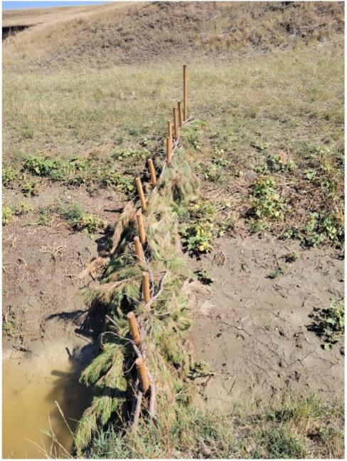
PRV2, located on a private ranch in Butte County, SD, was created in 2023 as a demonstration site for the project. Located on a seasonal to intermittent stream, this site has numerous areas of incision and entrenchment, and it is largely disconnected from its floodplain. A wider variety of structures were initially used on this site compared to others, including wicker weirs, post vanes, and bank-attached PALS. Initial results were promising, with many structures filling in with sediment before the end of summer 2023. However, in 2024, crews focused on building BDAs from pine brought in from the Black Hills (Figure 16). There was insufficient rain in the summer of 2024 to cause sediment movement, so the effectiveness of these new structures is yet to be seen.
Results on this site from 2023 and 2024 were promising, but there were some notable concerns. While the variety of structures built on the site in 2023 was highly effective at aggrading sediment initially, lack of rapid and adaptive maintenance led to scouring and damage in the winter of 2023-2024 when flows were higher. Cocklebur, an invasive and undesirable species, is also increasingly present on the site, especially near the LCLTT structures. Lastly, a few months after structure installation the landowner raised concerns about the safety of using pine (specifically ponderosa pine) to build structures in cattle pastures, after finding that their cattle were eating the needs from the pine boughs. Excessive consumption of ponderosa pine needles has been found to cause severe health issues in pregnant cattle, but the age and amount of needles present and consumed make it doubtful that this will pose an issue in this particular case. However, this does raise a potential issue with the choice of construction materials, timing of construction, and compatibility of BDAs and other LCLTT structures with certain livestock life stages that, to the best of our knowledge, has not been previously addressed.
<><><><><><><><><><><><><><><><><><>
<><><><><><><><><><><><><><><><><><>
<><>Anticipated research actions from 1/1/2025 to 11/30/2025<><>
- Dawson Uhl has been hired as an additional M.S. graduate student on the project. Dawson will be supported in part by this SARE grant, as well as an AFRI grant, with the purpose of further understanding how stakeholders view riparian restoration.
- James Bolyard will be submitting two manuscripts from his M.S. work that was supported by this SARE, both of which are intended for submission to Restoration Ecology (Impact factor = 2.8). We anticipate submitting the manuscripts March/April 2025.
- One manuscript will contain his research results (presented below).
- A second manuscript will present a model for state-and-transition models (STMs) being used for ecological sites that includes cross pollination with low-cost, low-tech techniques such as BDAs.
<><><><><><><><><><><><><><><><><><>
<><><><><><><><><><><><><><><><><><>
<><><><><><><><><><><><><><><><><><>
<><><><><><><><><><><><><><><><><><>
<><>Results and discussion as of grant completion, 11/30/2025<><>
Below we describe the results of the virtual fence riparian project support in part by SARE.
Note that this research project is ongoing, with an additional field season occurring in 2026, after which we will have definitive conclusions of the efficacy of using virtual fencing to manage cattle grazing access to riparian areas.
The following figures (Figures 17, 18, 19, 20) demonstrate the results we observed for average biomass, crude protein, neutral detergent fiber (NDF), acid detergent fiber (ADF), and utilization over the 2025 field season.
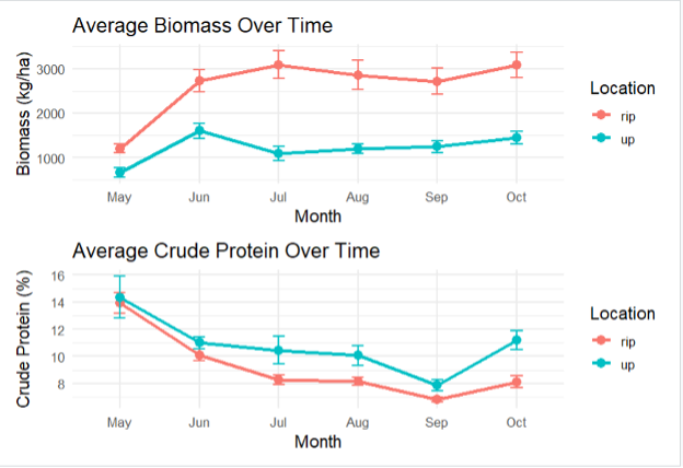
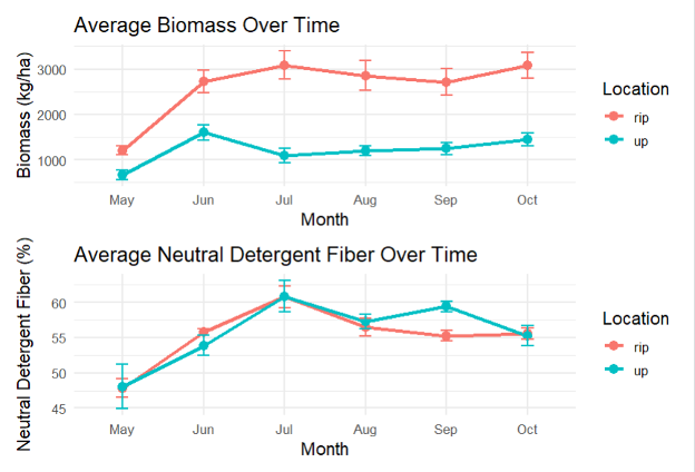
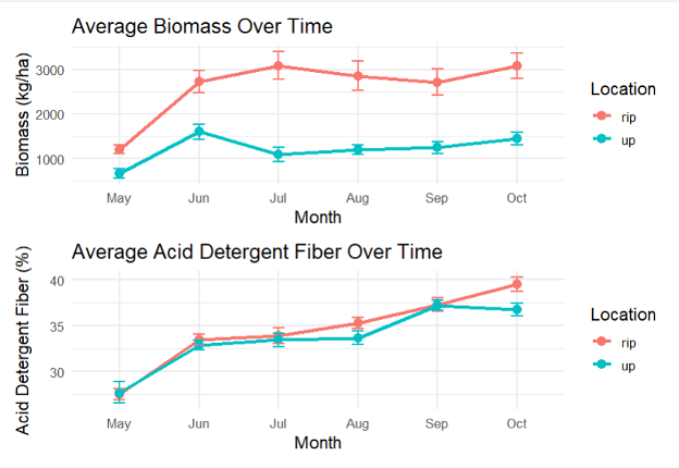
Riparian areas (rip) consistently produced substantially higher biomass than upland areas (up) across the entire growing season, roughly double throughout May–October. Both zones showed peak biomass in July, with riparian areas reaching ~3,000–3,100 kg/ha compared to upland areas peaking around 1,100–1,600 kg/ha. Biomass remained relatively stable from July onward in both zones.
Crude protein (Figure 17) declined sharply over the season in both zones, dropping from ~14–15% in May to ~8–11% by October — a typical seasonal pattern as forages mature. Upland areas maintained slightly higher crude protein than riparian areas through most of the season.
Neutral Detergent Fiber, NDF (Figure 18) increased over the season in both locations, converging near 55–56% by October. Upland areas showed notably lower NDF in May (~48%) compared to riparian areas, but the two zones became indistinguishable by late summer.
Acid Detergent Fiber, ADF (Figure 19) increased steadily across the season in both locations, with riparian areas finishing higher (~40%) than upland (~37%) by October — indicating riparian forage became less digestible later in the season.
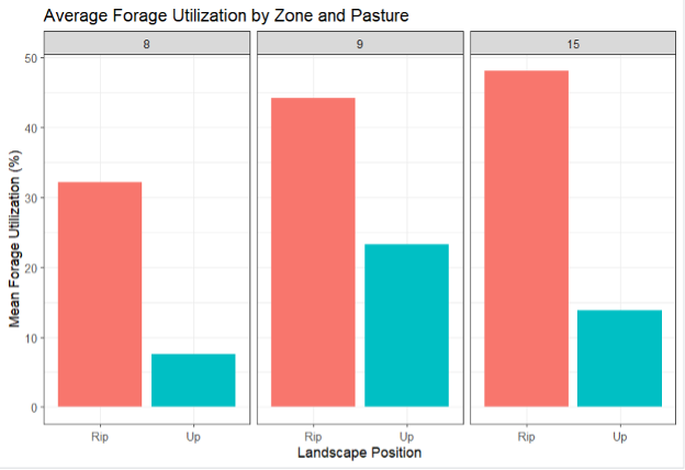
Riparian areas experienced substantially higher grazing utilization than upland areas across all three pastures (Figure 20). Riparian utilization ranged from ~25–48%, while upland utilization remained low at ~8–27%. This pattern was consistent regardless of pasture, suggesting cattle preferentially grazed riparian areas.
Overall, we found from the first year of this additional project that riparian areas offered higher biomass but declining forage quality late in the season, and cattle consistently used them more than upland areas. These findings support the rationale for using virtual fencing as a tool to more equitably distribute grazing pressure and protect riparian vegetation. Further, riparian areas play a disproportionately important role in rangeland forage systems relative to their spatial footprint. These zones benefit from higher soil moisture (as demonstrated), greater nutrient availability, and more moderate microclimates, which together support substantially higher forage biomass compared to adjacent upland areas. This preference grazing results in higher utilization of riparian vegetation (as demonstrated), soil compaction near stream banks, and degraded water quality - outcomes that are well-documented in the literature and clearly reflect the utilization patterns observed in this study. The value of riparian areas becomes even more pronounced during periods of drought, as often occurs in the Northern Great Plains. Managing cattle access to riparian areas - whether through traditional fencing or virtual fencing - is therefore not only a conservation strategy but also a practical management tool, ensuring that these highly productive zones remain resilient and productive across variable climatic conditions.
Overall, we found that low-tech, process-based restoration techniques such as beaver dam analogs (BDAs) have promise as a restoration tool in a semi-arid rangeland system within the Northern Great Plains. We found higher soil moisture and differences in plant community composition in areas that were restored with BDAs compared to areas that were not. Our additional virtual fence riparian project revealed the importance of riparian areas, particularly in drought-prone areas of the NGP, for forage production and quality over the grazing season. Our results also demonstrated that cattle more heavily use riparian areas compared to upland areas, providing a strong argument for leveraging virtual fencing as a management tool to manage cattle grazing on landscape scales.
Since we started this project, several partner entities - state, federal, and NGOs - have combined efforts to create the Black Hills Watershed Collaborative, ensuring a shared vision and planning for riparian restoration projects in western South Dakota. This was due in part, to this SARE project, as well as other riparian projects throughout western SD that have occurred over the last 5-8 years. The positive momentum and results of this project were shared with partner stakeholders and have spurred action for trainings and additional projects.
Education
2. Outreach and Extension Activities
New and unfamiliar practices are difficult to export without allowing ranchers and partners to see the benefits. The 5 producers involved in this project will serve as producer peer mentors (2 of which we have already identified, please see Commitment Letters). Producers will be compensated monetarily for their time and effort, with two payment schedules - one payment at the start of the project and one payment at the completion of the project. Working with producers will benefit the project in several ways. First, these producers own and operate on private and public lands, creating avenues for collaboration among multiple agencies (e.g., BLM and NRCS) and groups (NGOs like TNC, as well as SDSU). Second, new practices are sometimes perceived as high risk and if presented by NGOs, are perceived as threatening. Working with producers who have strong partnerships with TNC and SDSU will remove a layer of skepticism.
Workshops and Trainings: Workshops and trainings will be held at each producer’s ranch. The cooperating producer ranches will serve as an important bridge between the research aspect of the project and adoption of LCLTT to help restore riparian function. The focus of these workshops will be on riparian health education and implementation of LCLTT, and will utilize a new tool developed in cooperation with SDSU Extension, NRCS, and TNC - the Guide to Classification and Management of Western South Dakota Prairie Streams (“Stream Guide”). The Stream Guide provides valuable information to producers and technical staff on stream health metrics, and will serve as a basis for field demonstration days.
Workshops will discuss with livestock producers the importance of riparian health to livestock production, grazing management considerations for riparian areas, and the potential benefits and consequences associated with healthy and unhealthy riparian systems. We will use and point participants to sections of the Stream Guide that walk through how to conduct a stream health assessment. Additional tutorials will demonstrate to attendees how to assess current riparian condition and methods for measuring and monitoring riparian plant communities. During the workshops, we will introduce the concepts behind LCLTT restoration techniques to help dissipate energy from stream runoff and reconnect stream channels to floodplains. A focus of the program will be to highlight which stream reaches are appropriate for LCLTT restoration techniques to maximize success. We will then describe the materials and construction methods for installing BDA type structures within stream beds, as well as provide information for sourcing materials locally. Workshops will conclude by constructing a BDA on site.
Field Days: Field tours will be conducted at the CFS to highlight LCLTT methods for restoring riparian function. A benefit to hosting field days at the SDSU CFS is to demonstrate to producers that the organizations involved on this project (SDSU, TNC) are invested partners in restoring riparian function. A focus of the field days will be to discuss research results from the overall project including differences observed between treatment groups in biomass production, plant community composition, and soil moisture retention. In addition, overall landscape level benefits to implementing these strategies will be discussed.
Publications and Videos: We will use several avenues to disseminate information about this project. Extension publications will be used to communicate project status and findings to general audiences such as the public and producers. Once all data is collected, we will transform it into key takeways that will be shared in an Extension Fact Sheet. We will capture video using GoPros at specific parts of the project, namely during the site selection, material selection, and BDA construction phases. These videos will translate 1,000s of words into an easily digestible format that can be paused and rewatched countless times. Producer peer mentors will be involved in these videos, if they wish, so that their viewpoint can be recognized and shared with their peers. Peer-reviewed journal articles will share information with a wider scientific audience, and expand on the knowledge base of how LCLTT function outside of montane ecoregions.
Project Activities
Educational & Outreach Activities
Participation summary:
-Consultations:
- Bolyard J. Meeting with Newell Producer. 5/2022. Belle Fourche, SD.
- Bolyard J. Meeting with Philip Producer. 5/2022. Philip, SD.
- Bolyard J. Meeting with Belle Fourche Producer. 5/2023. Belle Fourche, SD.
<><><><><><><><>
-Journal articles:
<><><><><><><><>
-Published articles:
- Ehlert K and L Brown. 1/2023. Range Roundup: Riparian Health Project Started in Western South Dakota. https://extension.sdstate.edu/range-roundup-riparian-health-project-started-western-south-dakota
- Ehlert K, J Brennan, and J Bolyard. 1/2023. Ranching and Prairie Streams: Why Riparian Areas Matter. SDSU Extension article. https://extension.sdstate.edu/ranching-and-prairie-streams-why-riparian-areas-matter
- Ehlert K, J Brennan, and J Bolyard. 5/2024. Ranching and Prairie Streams: What Healthy Riparian Areas Mean for Your Ranch. https://extension.sdstate.edu/ranching-and-prairie-streams-what-healthy-riparian-areas-mean-your-ranch
- Ehlert K and J Brennan. 5/2024. Ranching and Prairie Streams: Riparian Vegetation. https://extension.sdstate.edu/ranching-and-prairie-streams-riparian-vegetation
<><><><><><><><>
-Webinars, talks, and presentations:
- Bolyard J, K Ehlert, and J Brennan. 9/19/2022. Low-cost, low-tech tools for riparian restoration. South Dakota Conservation District Annual Meeting. Chamberlain, SD.
- Direct contacts: 50 adults (10 producers)
- Bolyard J, K Ehlert, and J Brennan. 11/18/2022. Low-cost, low-tech tools for riparian restoration. South Dakota State University, Natural Resource Management Department seminar. Brookings, SD.
- Direct contacts: 40 adults.
- Bolyard J, K Ehlert, and J Brennan. 3/10/2023. Beaver biomimicry for stream restoration and rehabilitation. Black Hills Area Botany and Ecology Workshop. Rapid City, SD.
- Direct contacts: 75 adults. (5 producers)
- Bolyard J, J Brennan, and K Ehlert. 10/10/2023. Soil moisture response of the floodplains of intermittent prairie streams to low-cost, low-tech restoration. South Dakota Student Water Conference, Brookings, SD.
- Direct contacts: 60 adults.
- Bolyard J, K Ehlert, J Brennan, and L Brown. 1/29/2024. Low-tech process-based restoration of prairie streams in western South Dakota. Society for Range Management Annual Meeting, Sparks, NV.
- Direct contacts: 45 adults.
- Bolyard J, K Ehlert, and J Brennan. 10/16/2024. Unforeseen events: How natural and human-caused variability can impact process-based restoration outcomes. Prairie PBR Practitioner’s Meeting, Sheridan, WY.
- Direct contacts: 45 adults. (3 producers)
- to 13. Various. 2025. South Dakota State University YouTube playlist - Riparian Restoration: Stronger Together. Videos highlight different partner organizations that are working together as part of the larger riparian restoration effort in western South Dakota.
<><><><><><><><>
-Workshops and field days:
- Bolyard J, K Ehlert, and J Brennan. 10/12/2022. Beavers and low-cost, low-tech tools for riparian restoration. South Dakota Section - Society for Range Management Annual Meeting. Wall, SD.
- Direct contacts: 35 adults. (5 producers)
- Bolyard J. 8/23/2023. Process-based restoration with low-cost, low-tech tools in western South Dakota: Special considerations and lessons learned. Mesic Restoration Workshop with The Nature Conservancy. Hot Springs, SD. (10 producers)
- Direct contacts: 40 adults.
- Bolyard J. 9/5/2023. The importance of riparian areas and an introduction to low-cost, process-based restoration. Riparian Restoration Workshop. Newell, SD
- Direct contacts: 35 adults. (15 producers)
- Riparian Restoration 2.0 Workshop with Anabranch Solutions. Spearfish, SD.
- Direct contacts: 27 adults.
- Ehlert K and D Uhl. 8/15/2025. Riparian restoration and virtual fencing. SDSU Cottonwood Field Station Field Day. Cottonwood, SD.
- Direct contacts: 40 adults. (20 producers)
Learning Outcomes
- Understanding the importance of riparian areas
- How to implement process-based restoration - purpose and placement of structures
- How to implement process-based restoration - structure design
- How to engage landowners and other stakeholders
- Openness to adaptive management for riparian restoration and grazing practices
Project Outcomes
Changing grazing practices to account for riparian areas
Implementing adaptive management
Investigating virtual fencing as a tool for riparian area grazing management
Partnering with a stakeholder group (state, federal, NGO) to learn more about restoration practices or other cost-share methods that can improve grazing outcomes