2012 Annual Report for CNE12-100
Community Farmland Connections through a Targeted GIS Identification and Outreach Approach
Summary
Within a resurgence of interest in local food and farming, accessible farmland remains a key barrier to small-scale beginning farmer enterprises. In Massachusetts, 90% of farmland lost since 1982 is due to residential development concentrated in the 495 belt and Pioneer Valley. These are the same areas where farmland is sought by new farmers today. Building on a 2011 pilot project, New Entry is using local partners, GIS technologies, and our farmland data base and land matching programs to identify smaller parcels of land (2-5 acres each) connected to homeowners or commercial interests in at least six peri-urban communities. Typically, such plots have not been considered part of the farmable land base, yet are well-suited to beginning producers wanting to farm and direct market in their own communities. Land owners will be encouraged to make their land available to interested local producers. Workshops will explain the specifics of leasing land and farming on small plots to all parties. Zoning and other concerns will be addressed by partners to facilitate each community’s approval process. New Entry and local partners will help match landowners to land seekers, addressing access, infrastructure needs, leasing terms, and any factors that arise. Resource Guides will be developed for communities, landowners and new farmers in these and other communities to expand the process statewide. A database will track the land base in each community, interested farmers, and successful matches. This initiative will help solve a key barrier to the development of more sustainable community food systems.
Objectives/Performance Targets
Objective 1. Work with six towns to map available agricultural land
o To date, we have finished the majority of the work in 2 towns in eastern Massachusetts (Topsfield and Concord) and are still working with three other towns (Lincoln, Westport, and Dartmouth). Lincoln is well on their way of having a good inventory and then we will decide the best outreach strategy and educational workshop for these landowners. Westport and Dartmouth are not as far along.
o We have begun work with the agricultural community in Hamden County, which includes 23 towns. We will not work with each town individually, but will have regional meetings and a regional educational/informational workshop.
Objective 2. In each town, work with at least five landowners who wish to make their land available to a farmer.
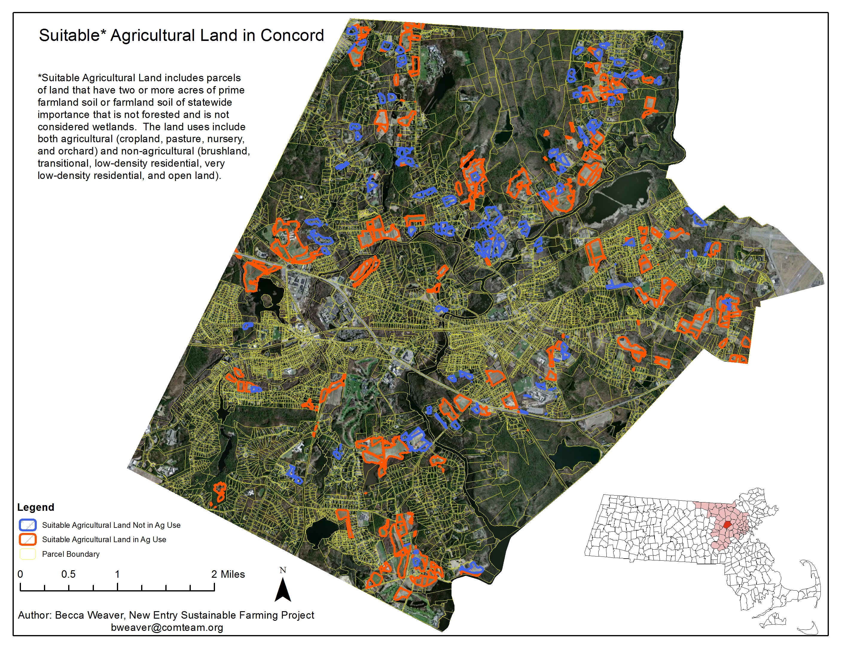
o In Concord, out of the 35 attendees for the land leasing workshop, we know for sure that there were 5 landowners who received the mailing who attended. Other people came to the meeting because they had heard about it from friends, through e-mails, or saw the flyer or poster at Ag Day in Concord. Of those who came to the workshop, only two came forward who were interested in leasing their land. We are currently following up with those landowners to see if a match may materialize. We have plans to repeat the mailing and informational workshop on an annual basis to continue to attract new prospective landowners.
o In Topsfield, out of the 25 attendees to the workshop, there were only two that came because they had received a letter. Others had heard about the workshop through the newspaper, an e-mail from us or Essex County Greenbelt, or because they have friends in the agricultural community. However, both those landowners who came to the meeting were interested in talking about making their land available. We are currently following up with them.
Objective 3. Increase the agricultural land base in each community by 10-50 acres. Status: we are not yet certain how this will develop until we work further with landowners who self-identify as willing to take the next step to lease their property to a new farmer.
Objective 4. Development of a field-tested tool-kit for community organizations wishing to undertake this work. Status: We have been compiling stories and results of the project to develop this tool kit from the beginning and will be working on a draft this spring as the Hamden County Project and the Town of Lincoln are finishing up.
Objective 5. Develop an Enterprise Planning Guide for producers using a small parcel approach. Status: A draft of this guide has been written after interviewing a handful of different farmers from MA and around the country who use multiple small parcels for commercial growing. Final case studies are being written so that we can finalize this guide this spring.
Accomplishments/Milestones
Feb 2012: We presented information at two regional agricultural commission meetings, one in Franklin County and one in Berkshire County. We presented the information about our pilot project (land outreach) in Groton and let other agricultural commissions know that we are looking for more pilot communities. We found that at the meeting, many agricultural commissions seemed interested to work with us because of the map of agricultural land/parcels that they would receive through participation in the project.
March 2012: We presented information at the Massachusetts Association of Land Conservation Trusts annual meeting with two other presenters, Kathy Ruhf and Pete Westover. Kathy talked about different types of lease agreements, Pete showed examples of agricultural enterprises on conservation land, and Becca Weaver (SARE project PI) presented the project with Groton to map agricultural lands and match farmers to under-utilized agricultural land. At that session were the chairs of the Concord Agricultural Committee and the Lincoln Agricultural Commission. They both came forward after the presentation inviting New Entry to work with their communities.
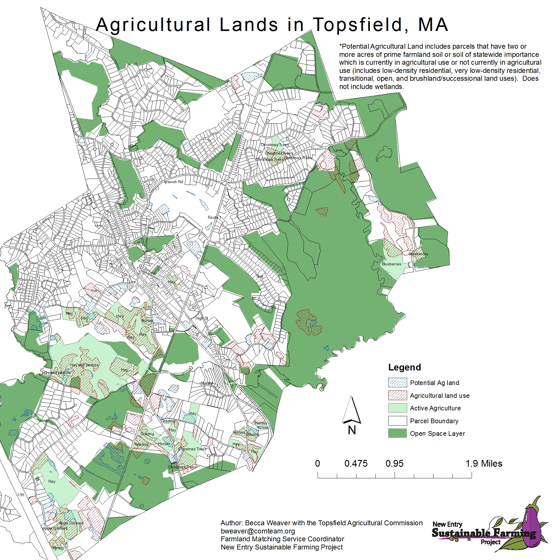
April 2012: The Topsfield Agricultural Commission contacted us because they were interested in learning more about the project. After presenting information at one of their meetings, they were very excited to implement the project in Topsfield. We worked with them for the entire summer, attending one meeting a month with the Ag Commission. We piloted the use of Google Earth with our Arc-Map generated maps in order to have an engaged agricultural inventory process with the agricultural commission.
May 2012: We began to work with representatives from the Southeastern Massachusetts Agricultural Partnership (SEMAP) and The Trustees of Reservations (TTOR) in Southeastern Mass because they were interested in doing this type of project in their region of Massachusetts. They decided that Westport and Dartmouth would be ideal communities to work with because of the dual nature of the high-development pressure and the active agricultural community. During the summer, they tried to figure out times to present the work to key stakeholders in the agricultural community there, but did not find a time, as the agricultural commissions were very busy during the summer.
June 2012: We met with the Concord Agricultural Committee to present the project that we could do with them. They were interested in seeing the map of our agricultural analysis of their town, but were more excited about hosting the agricultural land leasing workshop in their town, rather than the inventorying process itself, which they had already put some effort into in the community and had several land maps already developed.
We also presented the project to the Lincoln Agricultural Commission (at a separate meeting). They were excited about the project, but know that much more mapping has been done in their town of agricultural land and they also have most of it utilized as a result. Therefore, the agricultural commission chair, Becca Weaver, and the conservation commission GIS technician met together to decide on the best way forward. The Ag Commission Chair determined it was best to wait until the new parcel data layer was ready for the Town of Lincoln before a new analysis is conducted. The Lincoln Ag Commission also had resources to hire a student intern to help with outreach work.
Interviews were also done over the summer with farmers who use multiple small plots for agricultural production. A draft of a guide was written up at the end of the summer based on their experiences.
July 2012: We met with the Topsfield Agricultural Commission in the offices of the Topsfield Agricultural Fair Buildings with a projector screen hooked up to the computer processing Google Earth images and zoomed in and out to all the identified properties on the map. The commission members then identified who was doing what where in their community and identified parcels that offered opportunity for new agriculture. In the end, we had a map of available land and active land. We chose to send letters to the landowners of the properties that were not already in active agricultural use.
August 2012: We prepared mailings for the towns of Topsfield and Concord. Concord decided that they wanted to send a letter to everyone in town who was identified with the GIS analysis, conservation easement properties, and people enrolled in the Agricultural Use property tax program. For Topsfield, we used the revised list of landowners that we generated after the Google Earth inventory process.
September 2012: We sent the mailings to the Concord and Topsfield Residents. We invited them for two different workshops, one planned for Topsfield on October 22nd, and one in Concord for October 10th. During September we also tabled at Concord’s Ag day and wrote a blog post for the Concord Sustainable Food Systems Network for outreach purposes. In Topsfield, we sent a press release about the workshop which was picked up in the local paper, the Tri-town Transcript (see http://www.wickedlocal.com/boxford/newsnow/x1826354337/Learn-how-to-lease-your-land-to-a-farmer-at-workshop-Oct-22#axzz2BYF75VdV). The host, Alfalfa Farm, also put the information about their workshop in their newsletter.
Pete Westover also organized a meeting between New Entry and the Pioneer Valley Planning Commission who was working on putting together their food security plan for the Pioneer Valley. After meeting, we all decided that it would be extremely productive to include the mapping project in their food security plan as an implementation step for one of their goals, “Grow more food.” We decided that we would map all of Hamden County and get all the towns involved at once to look over their respective maps and hold a regional workshop. The meeting with the agricultural community is scheduled for January and the workshop on leasing land to a farmer is scheduled for March 2013.
We continued to work with our partners in Southeastern Massachusetts and attended two agricultural commission meetings in the region, one in Westport and one in Dartmouth. The Town of Dartmouth let us know that they had a good inventory of agricultural land and had already worked a lot on matching new farmers with land, but that they would be happy to work on this project with us as a way to continue the work that they already do. Westport had not done anything like this in the past, and they were interested, yet not so enthusiastic about working on the project. The staff at SEMAP and TTOR seem to be very busy and they have not been able to organize any other meetings (as of year end) with these two communities.
October 2012: We held two workshops on “leasing your land to a farmer”, one in Concord and the other in Topsfield. The Topsfield workshop was attended by a reporter from the Tri-town Transcript who wrote another article about the workshop (see http://www.wickedlocal.com/boxford/newsnow/x1745959353/Local-landowners-and-farmers-learn-about-leasing-land-at-Alfalfa-Farm-seminar#axzz2CmbfIb8y)
November 2012: We generated a new map for Topsfield of their land in agriculture that they can put on their Town’s website. During our follow up meeting the commission members also decided that they would like to host a regional meeting of agricultural commissions for the spring in order to share this project with their neighbors and see if other towns’ agricultural commissions would also like to get involved. Their hope is to host a workshop on leasing land to farmers next fall that will have a regional pull, rather than just include residents from their town.
In Lincoln, we got the updated parcel information and completed the GIS analysis for Lincoln. We then worked with the intern they hired and the Conservation Commission GIS employee to look at how our analysis compares to the agricultural field layer they already have. The intern is now working on combining the two data sets and making more exact analyses so we can present the information to the Lincoln Ag Com and see how they would like to proceed with activities and outreach.
December 2012: We met with staff from Nuestras Raices, an immigrant farming program based in Holyoke, MA about the need for new agricultural land for their project and for their farmers that are graduating from their program. They excitedly let us know that they are looking for land for their program participants and would love to work with us on outreach and education in Hamden County in order to find land for their farmers. Additionally, a feature article (front page) of the 12/3/12 Boston Globe featuring the innovative land matching program and one of our successful Groton matches was published. Additional inquiries have been received as a result of the article. http://www.bostonglobe.com/business/2012/12/03/for-would-mass-farmers-matchmaker-that-knows-land/YkcV3I8H5iR92o92xlbQGK/story.html?camp=newsletter
Impacts and Contributions/Outcomes
Because we have not yet completed all the project steps to finalize the process of outreach, communications, and the continual process of following up with landowners or matching farmers to land, it seems that the biggest beneficiaries of this project to date have been the agricultural commissions and the existing agricultural communities that we have worked with thus far. Working on an inventory project and holding an educational meeting in an individual town gives a towns’ agricultural commission a reason to come together to work for a common goal. They are able to put together an inventory of their agricultural lands and soil resources that they can look to when other new farmers come to their community and inquire about possible open agricultural land. We have worked with them to get articles in the paper written about the work and the landowner workshop which gives positive press to agriculture in a particular community. In Topsfield and Concord, the agricultural commissions want to put on a workshop every year, as they see it will be vital for educating their community about the importance of agriculture and how to support it. In addition, the commission recognizes that the value of land is increasing in their town, and for new farmers to join the community it will probably be necessary for them to rent land from some of the more wealthy landowners, at least in the beginning.