Final Report for OW10-310
Project Information
In order to accomplish the project’s purpose of studying sustainable alternatives to the Conservation Reserve Program, we discovered that the ability to adapt to unanticipated changes is a key component of sustainability, along with the three legs of sustainability: environmental, economic and social. In moving this project forward, we had to adapt in order to find landowners with expired or expiring CRP-contracted land who were willing to forego the economic benefit of re-enrolling in the CRP program and allow grazing as a restorative practice of the degraded CRP lands. Ultimately, we had to rely on public CRP-like lands.
Introduction
Background of Problem:
This country has over 29 million acres of idle land that by contractual restraints under the Conservation Reserve Program is non-productive, often unmanaged, and is part of the cycle of government spending that results in questionable benefits, as pertaining to the ecosystem or local economies. Our project purpose was to research and educate others about sustainable alternatives for idle lands.
Literature Review:
The Conservation Reserve Program (CRP) began in 1985. Since then, this government program has been identified as a key subsidy program for the conservation of highly erodible lands and to benefit wildlife. Washington state currently has over 1.46 million acres of land enrolled in the program, with over $83 million paid out to landowners each year. In the next three years, over 497,000 acres of CRP land will be expiring (Conservation Reserve Program statistics, 2013). Over the past 15 years or more, the CRP has tightened limits on options to manage enrolled lands; the result is old, decadent stands of oxidizing, dying bunchgrasses. Grazing, in particular, has been restricted as a management tool, even though many of our grassland ecosystems co-evolved with herbivores (Stebbins, 1981). Livestock grazing is not only a valuable conservation method but is oftentimes the best method.
References
Conservation Reserve Program Statistics. United States Department of Agriculture, Farm Service Agency. Available online at http://www.fsa.usda.gov/FSA/webapp?area=home&subject=copr&topic=rns-css. Accessed 3/25/2013.
Herrick, J. E., Van Zee, J.W., Havstad, K.M., Burkett, L.M., Whitford, W.G., 2005. Monitoring manual for grassland, shrubland and savanna ecosystems. Volume II : Design, Supplementary Methods and Interpretation. USDA-ARS Jornada Experimental Range. Las Cruces, NM. 200p.
Land EKG, (1994). Rangeland monitoring tool. Online at http://www.landekg.com/index.html.
Stebbins, G.L. (1981). Coevolution of Grasses and Herbivores. Annals of the Missouri Botanical Garden. 68(1), 75-86.
On-Farm Research:
1. Develop criteria to evaluate the suitability of expiring CRP tracts for grazing, cropping, outdoor recreation and/or wildlife habitat (Timeline: summer 2012)
2. Evaluate methods of rejuvenating or inter-seeding into existing CRP stands to improve pasture quality (Timeline: fall 2010-2013)
3. Mob grazing with dry cows during the fall dormant season, followed by grazing of yearling cattle during the spring growing season
4. Mob grazing during the dormant season with broadcast of seed for grasses, forbs and legumes
5. Mob grazing, followed by seeding with a rangeland drill
6. Small plot trials of seed mixtures for pasture
Demonstration:
7. Demonstrate through on-farm field days and two multi-farm tours (Timeline: summers 2012 and 2013)
8. Complimentary agriculture and recreation enterprises
9. Farmer-friendly ecosystem monitoring system
10. Effective use of temporary electric fence and portable animal watering systems
11. Demonstrate through traditional Extension in-person training and webinars (Timeline: Spring 2012)
12. On-farm research design and analysis
Cooperators
Research
Changes since submitting original project proposal - How adaptation is part of sustainability:
Initially we were to conduct the Sustainable Alternatives to Conservation Reserve Program Project on G & L Farms (Gregg Beckley; Benge, WA). Beckley is the owner/lessee of 6,000 acres (5,000 acres in CRP) of cropland. Plans and economic analyses were made to convert 1,162 acres of leased ground to a managed rotational grazing system. Progress was being made to use the Environmental Quality Incentive Program (EQIP) to cost share fence and water development.
Beckley also diversified his operations to gain revenue from outdoor sporting activities, including recreational horseback riding and hunting, which expanded to 40,000 acres through a cooperative agreement (Blue Ridge Ranch) with adjacent landowners. An economic analysis of cow-calf to grass-finished beef on CRP-like range ground was completed and published (see EM 010).
In 2010 the Farm Service Agency (FSA) announced a new CRP sign-up. Beckley decided to retire so he pursued the CRP enrollment of his improved pasture and the 1,162 acres of expiring CRP land. Cattle producer-collaborator Dick Coon, who had been the proposed cattle manager and was to be a collaborator on this project, decided he no longer wanted to participate due to other demands on his time. Robert and Janet Phinney, who were also listed as producer-collaborators in our original project proposal, also opted out. Thus we have had to revise our plans and recruit new producer-collaborators. As a result, we obtained two new producer-collaborators, John Pearson (Colfax, WA) and James Wahl (Lind, WA).
John Pearson
John Pearson is a cattleman and the owner of Pearson Farm and Fence (Colfax, WA), a business that contracts fence building, as well as sells K-Line irrigation systems, fencing supplies and farm equipment.
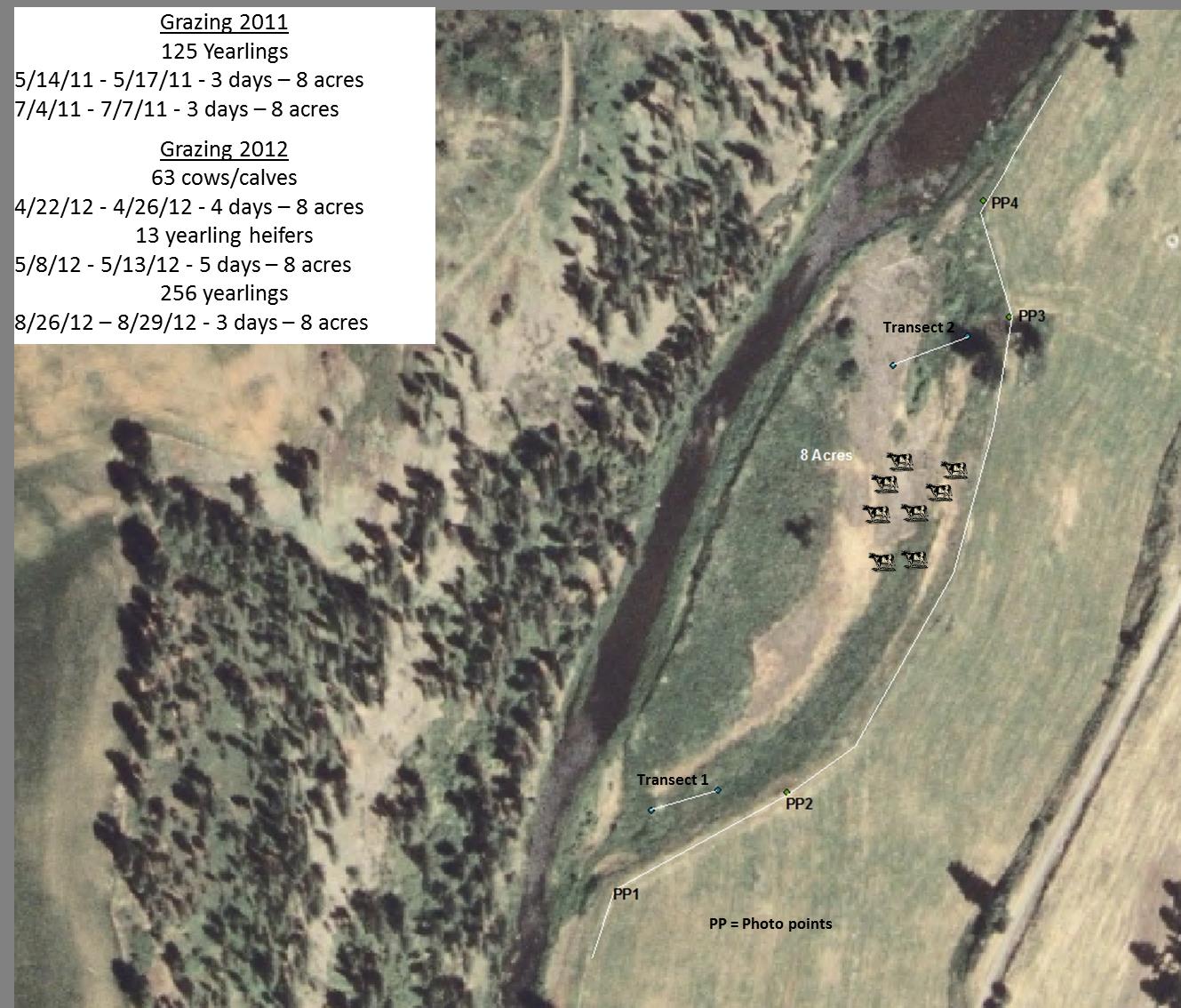
The project team developed a demonstration study on eight acres (Figure 1) of riparian pasture owned by Pearson on the north fork of the Palouse River that had been in continuous CRP since September 1999 (contract expired September 30, 2010).
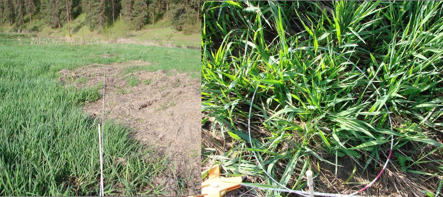
The primary vegetation on the CRP site included common tansy, reed canary grass, willows, annual grasses and patches of spotted knapweed. Pearson implemented short duration, high intensity grazing on this site in the spring and summer of 2011 and 2012 (Figure 1). Data prior to and after grazing was collected. Vegetation and biomass changes were monitored via two 100 foot transects and four permanent photo points using the Land EKG monitoring system (Land EKG, 1994). All vegetation cover data was collected on a percent cover basis along transects using 4.7 foot two sampling hoops every 25 feet. (Figure 2).
James Wahl
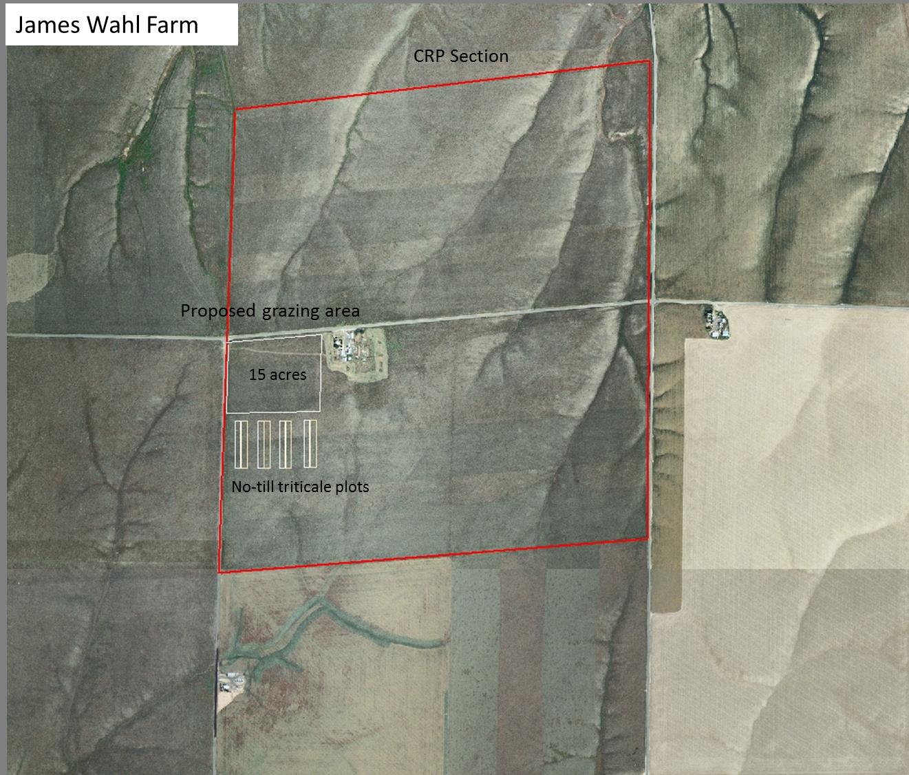
A demonstration study area was designed for approximately 20 acres within a 294.8-acre field (Figure 3) that is currently under CRP contract with James Wahl, a Lind, WA farmer, on October 26, 2010. We seeded five acres of triticale (four forage varieties) at 80 lbs/acre, which was intended for rotational grazing within the 20-acre site. The project team applied to the USDA Farm Service Agency (FSA) for a research exemption to graze the study area with cattle; however, our request was denied. We then followed up with a request to the FSA for approval to graze between July and October, 2011, which was approved, although it would entail paying a 25% CRP payment penalty of about $15/acre (Appendix 1 & 2). This study was intended to investigate and demonstrate the agronomic, economic and environmental benefits of cattle grazing and triticale over-seeding on CRP ground; we were to further assess triticale grain and forage varieties and seeding rates for optimum production. In the spring of 2011 (March/April), the FSA approved another re-enrollment of CRP. During this time James Wahl pursued re-enrollment of his expiring CRP contract, thwarting our plans to begin grazing in the fall of 2011. Once again, we had to pursue other cooperators for grazing CRP land. As a result, we enlisted the support of Frank Garrett as a cooperator.
Frank Garrett
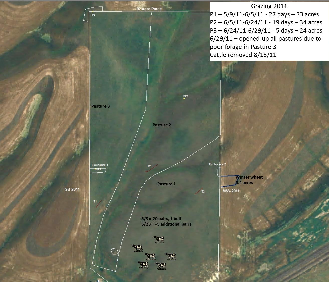
Upon acquiring Frank Garrett as a cooperator, we developed yet another CRP grazing project specifically designed to fit his situation. Frank was leasing from his daughter-in-law a 92-acre parcel of land (Figure 4) that had expired from a CRP contract in September 2009. Frank had grazed the parcel from May 6 through October 3, 2010, with 28 pairs and 1 bull. In the spring of 2011, we set up the study area in order to graze three rotation pastures throughout the 2011 growing season. To monitor and evaluate the grazing impacts, we established and have been using three EKG transects and three permanent photo points. We also established two grazing exclosures as a check area without grazing utilization. We also fenced off a small area (0.4 acre) in the neighboring winter wheat crop to demonstrate the effects of grazing on crop production; 20 head were allowed to graze the crop area for four hours on May 23, 2011.
After collecting data throughout the 92-acre block during the grazing season in 2011, we were advised that the landowner was signing up the 92 acres into CRP starting September 2011. We were able to access the site and collect the resulting data from the site in 2012 but could not continue to graze the area. Once again we had to scramble to find another cooperator.
During this time Western SARE collaborator/investigator Steve Van Vleet was conducting a grazing study at the Dalles Mountain Ranch. As with the Western SARE project, the goal of the Dalles Mountain Ranch project was, and continues to be, restoration of degraded grassland to return it to healthy and productive land.
Dalles Mountain Ranch-Columbia Hills State Park
The Dalles Mountain Ranch, located near Dallesport, WA, is a historic ranch dating back to the 19th century. Within the ranch is a 180-acre parcel of rangeland that had been used for livestock production for decades before being acquired by Washington State Parks in 1994. In 1992, while still privately owned, the pasture and native range were tilled and planted to Secar bluebunch wheatgrass and Sherman big bluegrass and then left idle, ultimately becoming a monoculture of Secar bluebunch wheatgrass with patches of invasive weeds. This exemplifies what has occurred with idle CRP land throughout Washington State. Since acquiring Dalles Mountain Ranch, the State Parks officials aspired to manage the historic ranchlands in a sustainable and ecologically conscious manner, but were without the knowledge and means to move forward. A team of research scientists was assembled to accomplish this objective.
The State Park’s objectives for operating the ranch were and remain as follows:
• Maintain the ranch as a historical site
• Showcase the ranch as a learning site (to include the training of public and state park employees on proper management methods and to validate desirable methods of managing public lands that have been unfairly dismissed)
• Identify, assess, monitor, protect and restore plant and animal communities associated with grasslands, oak woodland, and spring-fed riparian areas
• Publicly promote the ranch (much like central Idaho’s “Running of the Sheep”)
• Incorporate limited livestock production using state-of-the-science management
• Demonstrate techniques to hold family ranches together
• Manage invasive weeds entering park land
The project team had determined that managed grazing using cattle during the dormant season was the optimal tool to restore the idle grassland. To diffuse the concerns of the environmental community about allowing livestock to graze public land, the project team conducted several on-site sessions with members of the Native Plant Society and Friends of the Columbia Gorge to jointly evaluate and document the plant ecosystems of the degraded grassland. A proposed plan to rehabilitate the idle grassland using managed rotational grazing was submitted, circulated, revised and fine-tuned over a period of nearly a year before it met with the approval of State Parks, Friends of Columbia Gorge and the Native Plant Society (Appendix 3). A cooperative work permit between WSU and Washington State Parks was secured in 2009 and the plan was put into play.
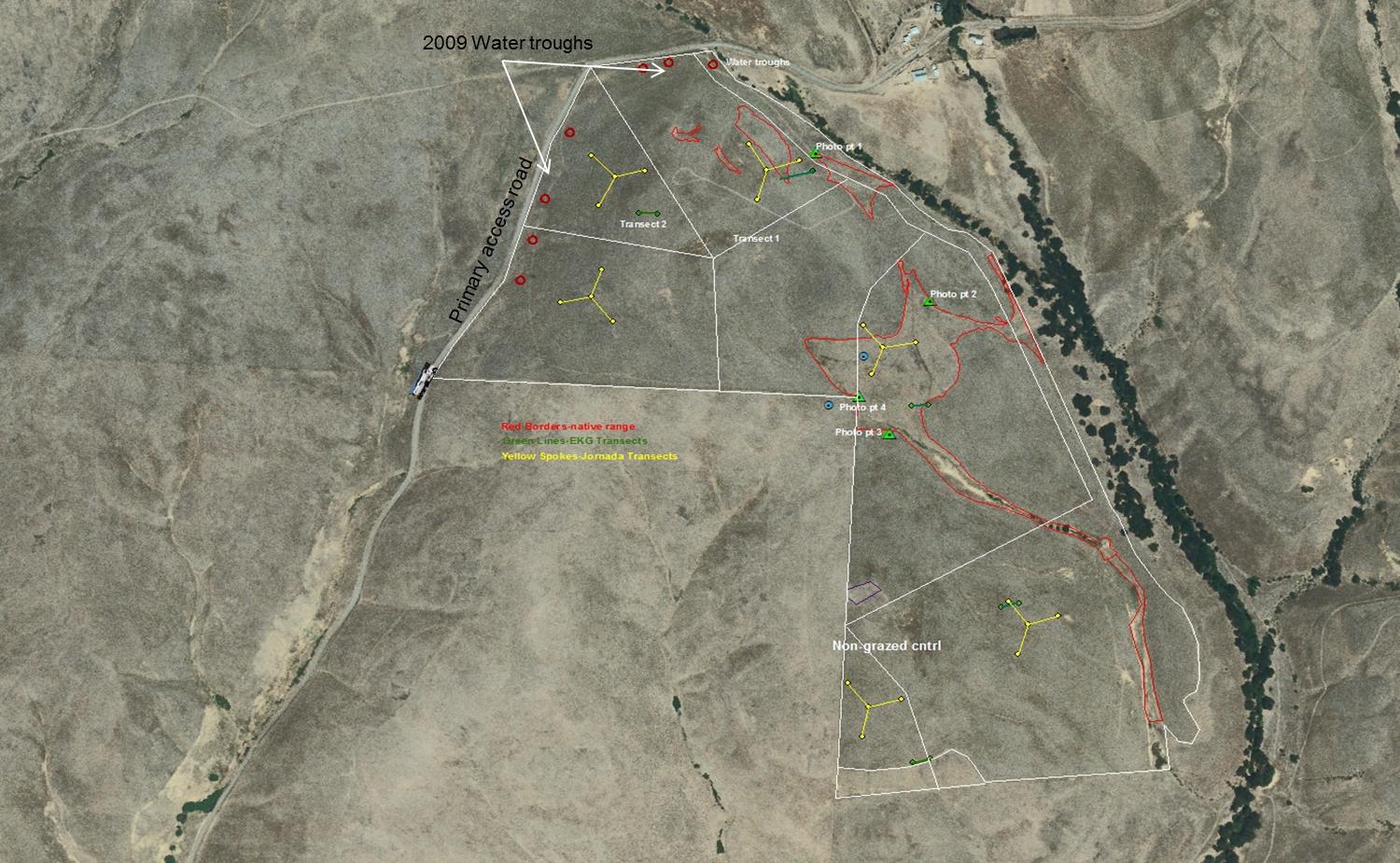
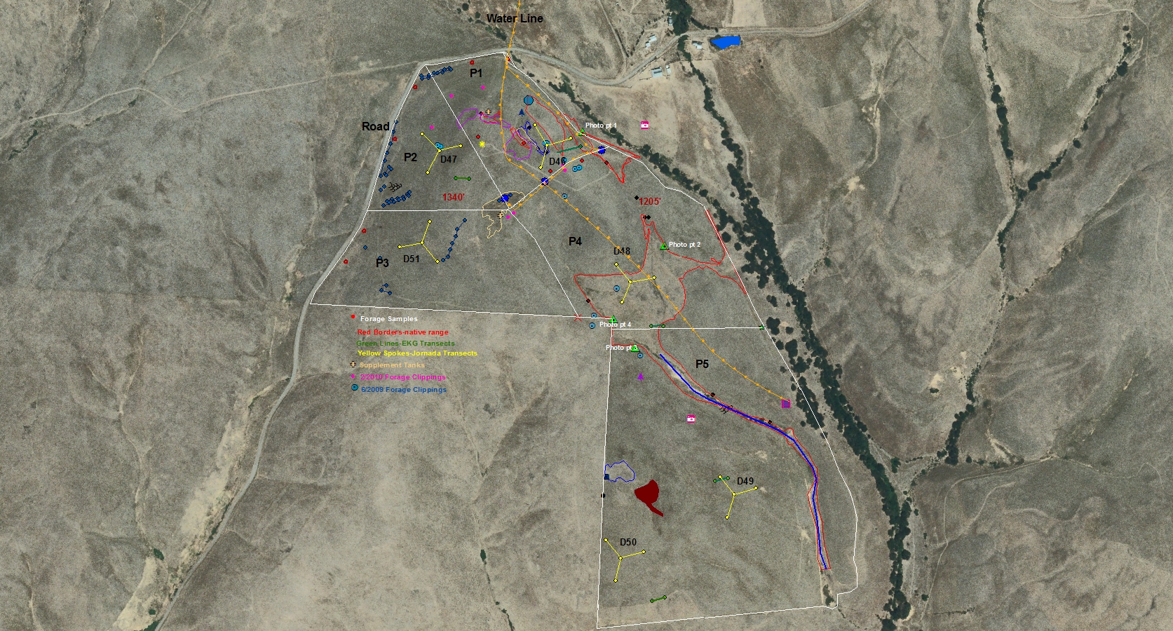
Prior to introducing livestock onto the project site, various data-collecting mechanisms were set in motion. Jornada sampling transects (Herrick, et al 2005) were placed in each pasture, while Land EKG transects and five permanent photo points were established throughout the project area. Biomass clippings were taken to estimate stocking density, forage availability and forage utilization throughout the duration of the study. All fence locations, sampling points, biomass clippings, invasive plant populations, watering areas, native plant habitat and revegetation areas were mapped via GPS (Figure 5). Annual precipitation data was collected on site from October to September of each year for the duration of the study.
In 2009, the trial was setup to have water delivered by truck to tanks in each pasture targeted for grazing. Entrance into the field became impassible and the study was redesigned to have water delivered directly to water tanks along the primary access road. This setup was also not ideal: water distribution was difficult to manage and pasture utilization was limited (Figure 6).
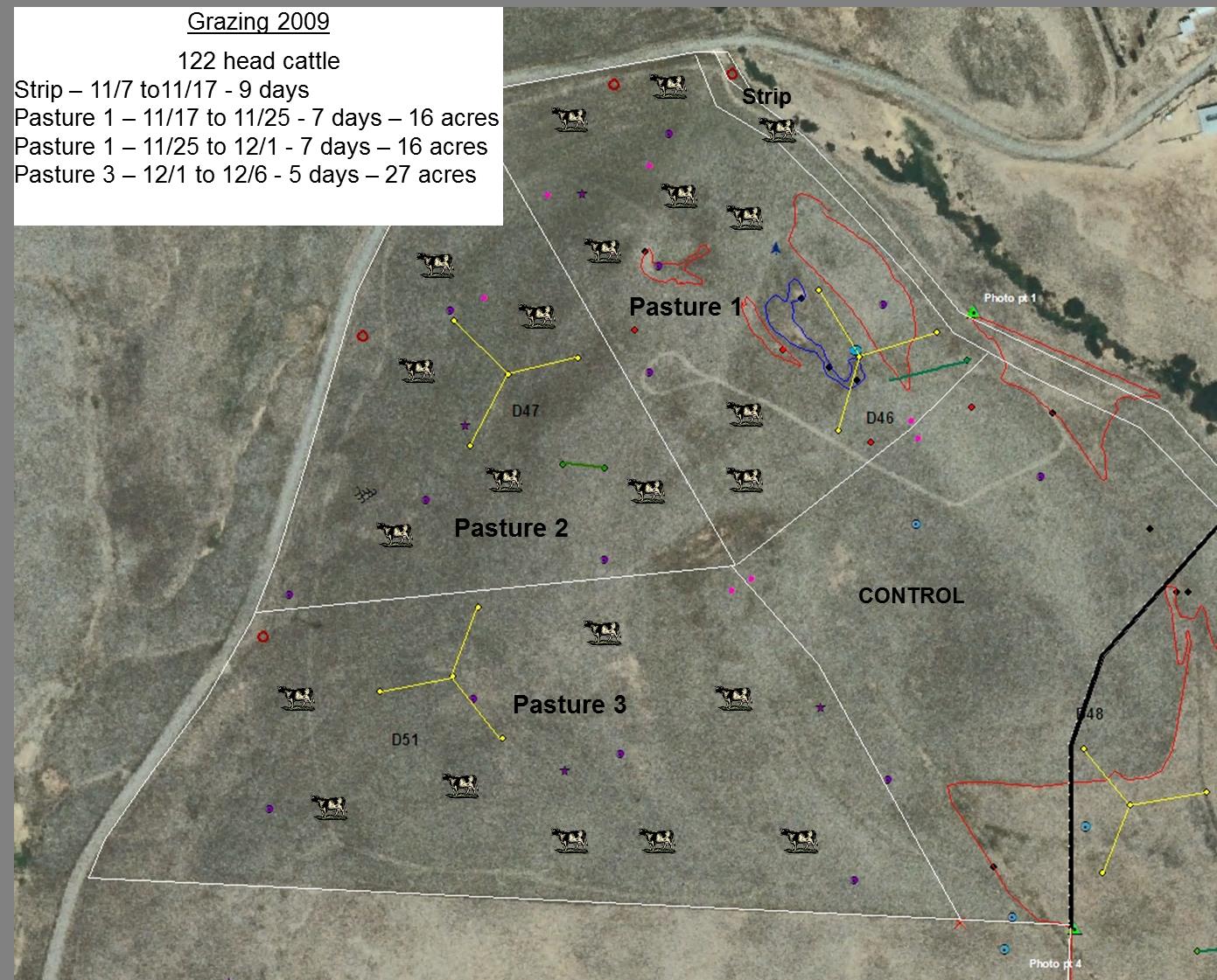
The managed rotational grazing portion of the project began in November 2009 (the dormant season) and lasted one month (Figure 7). Initially, 122 cows were placed in a strip that accessed 55 acres of pasture (pasture 5).
Although not originally scheduled, the cattle grazed continually within the strip which was not the objective; however this turned out to be a good comparison area for high intensity mob grazing. The cattle were then rotated through pastures 1-3 from November to December. Grazing was cut short in pasture 3 due to inclement weather.
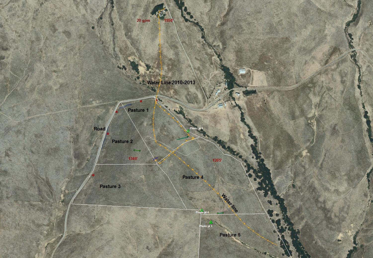
Over the summer and early fall of 2010, a watering system for the livestock was developed. In cooperation with State Parks, a water line was installed from the ranch house to the pastures (Figure 8). Grazing was scheduled to begin in early November; however, a snow storm came through and the weather remained problematic, so the grazing was suspended for 2010. The loss of the 2010 grazing year did, however, allow us to look at how the grasses recovered after a year of rest.
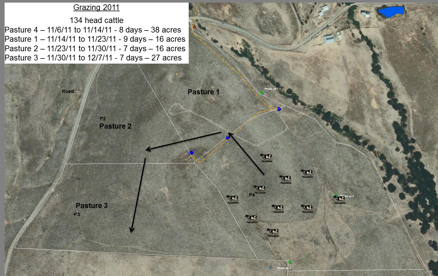
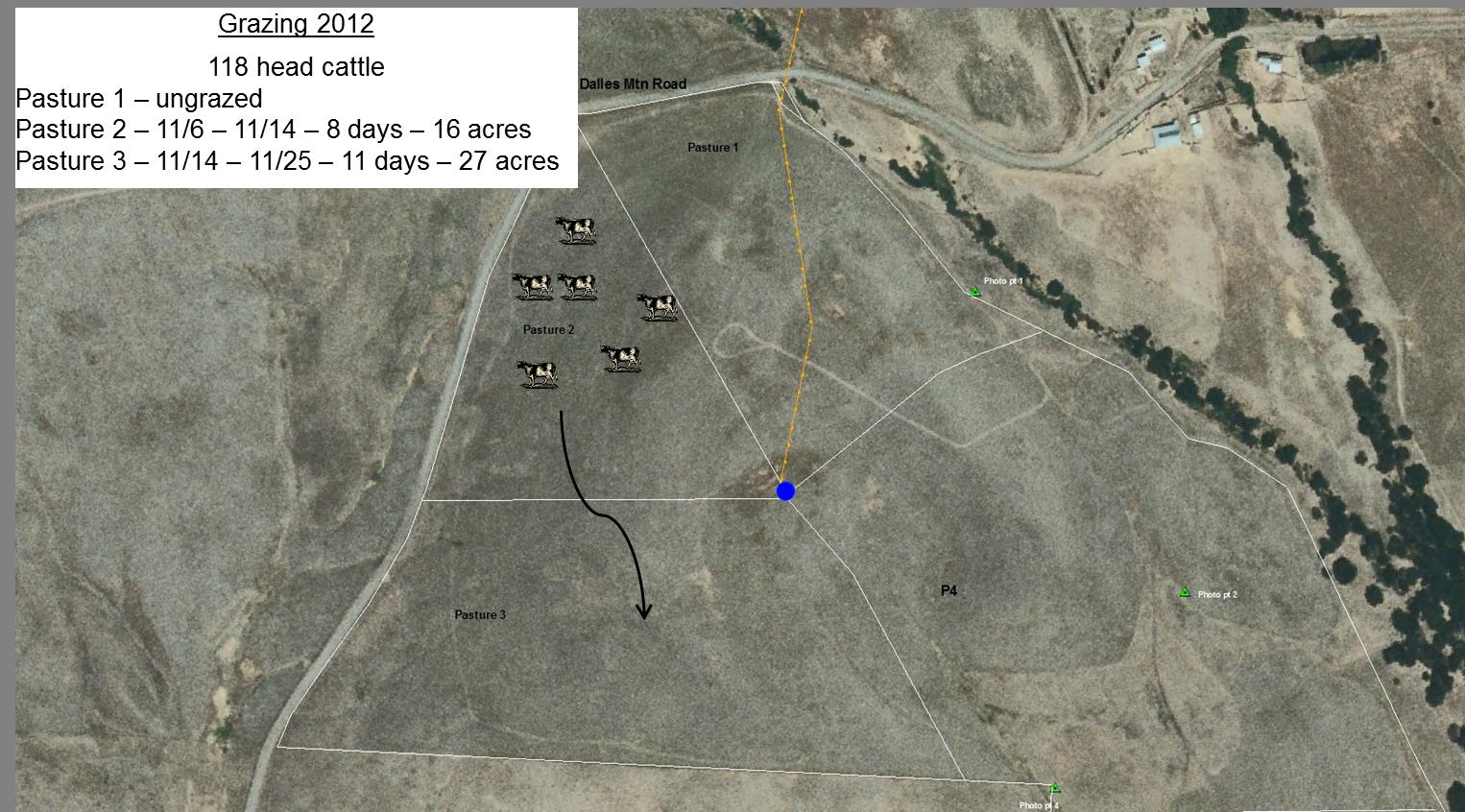
On November 6, 2011, we initiated grazing by releasing 134 head of cows into pasture 4. The cattle were rotated through pastures 1-3 and removed on December 7. We would have liked to have seen additional grazing pressure on pasture 3 in 2011, but grazing was ceased somewhat early amid concerns of the livestock producer about the state of his livestock due to the poor weather conditions. In 2012, grazing began on November 6 with 118 head cattle placed in pasture 2. The cattle were removed from the study site on November 25 (pasture 3), earlier than planned due to cattle getting out of the fenced pasture. The grazing schedules for 2011 and 2012 can be seen in (Figures 9 & 10).
We also wanted to examine the effects of spring grazing, so on April 24, 2012 we implemented grazing in pasture 5 on the heavy bluebunch wheatgrass and a small native area of grasses and forbs (native areas composed primarily of lupine and arrowleaf balsamroot). We allowed the spring grazing to continue for 15 days using 57 cows and calves. Photos, biomass clippings and ground cover data were collected and will continue to be collected from this area in 2013 and 2014 to determine the impacts of the 2012 spring grazing.
Data was collected each year from all grazed pastures on ground cover (Land EKG transects), dry matter feed analysis and photos were taken from permanent photo points. The primary data collection period for gaining the most relative data on grazing impacts was determined the first week of May (peak vegetative production/cover for the grasses and peak production/cover/bloom for a majority of forbs). Upon collecting the data from the Jornada transects, we determined that Jornada transect sampling did not provide us with relevant data when evaluating changes within the large scale ecosystem of the Dalles Mountain Ranch. The reason for discarding the Jonada transect evaluation is due to each sampling point along the transect having such a large degree of variability at each evaluation time. The Land EKG transects with percent cover sampling areas, photo points, pre- and post-grazing biomass clippings and dry matter feed analyses provided us with the most relevant data.
Revegetation studies
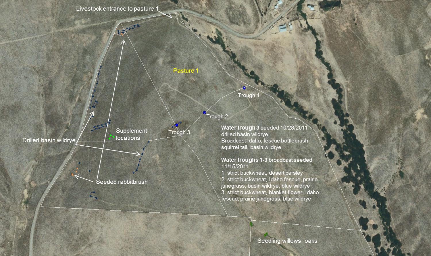
Rehabilitation of this grassland ecosystem is part of our goal and in collaboration with the Native Plant Society we re-vegetated some areas within the project site. We drilled approximately an acre of basin wildrye with an Aitchison grass seed pasture drill in relatively bareground patches of pastures 1-3 at 10, 15 and 20 lbs/acre on October 28, 2011. We also broadcast seeded basin wildrye, Idaho fescue and bottlebrush squirrel tail grass in areas that would have high animal impact (water trough, supplement and salting locations) during the 2011 grazing period. During the 2011 grazing period, we again broadcast seeded high impact areas with a combination of blanket flower, Idaho fescue, native bluebunch wheatgrass, strict buckwheat, desert parsley, prairie junegrass, basin wildrye and blue wildrye. After the cattle were removed from the site on 12/16/2011, we broadcast seeded strict buckwheat, desert parsley, basin wildrye, blue wildrye, prairie junegrass and bottlebrush squirrel tail in the high impact livestock entrance area to pasture 1 (Figure 11). We are monitoring the establishment of the seeded species but were not able to quantify results in 2012. The Native Plant Society wanted to include some shrubs and trees into the re-vegetation process. On November 14, 2012, we seeded six rabbitbrush plants, and on December 3, 2012 we planted 100 willow tree and 60 oak tree seedlings. We will continue to monitor the establishment of our re-vegetation efforts throughout the study site in 2013-2014.
- Transect line and sampling hoop along transect line
- Proposed grazing study on Wahl farm
- 2011 number cattle, grazing location and grazing period
- 2011-2012 Revegetation at Dalles Mountain Ranch
- Initial FSA Research proposal for Wahl farm
- Dalles Mountain Ranch Rehabilitation Proposal
- 2012 number cattle, grazing rotation, grazing period
- Second FSA Research Proposal for Wahl Farm
- Livestock watering setup 2009
- Grazing study on Garrett farm
- Developed livestock watering delivery system
- Grazing at Pearson farm
- Dalles Mountain Ranch grazing study 2009-2012
- 2009 number cattle, grazing location and grazing period
Through the collaborative efforts of different groups and individuals and with Western SARE’s funding, this project will continue for several years beyond what the Western SARE funding allowed. The Native Plant Society, Washington State Parks, livestock producers and key WSU faculty have raised awareness of this project and similar projects are currently being developed in regions throughout Washington State.
Research outcomes
Education and Outreach
Participation summary:
• May 2010: Wagons and Wildflowers Event, Dalles Mountain Ranch
• September 2010: Land EKG Training and Seeding Trial Evaluation, G & L (Beckley) Farms
• April 2011: Oregon/Washington Native Plant Society Seminar, Columbia Gorge Community College, The Dalles, WA
• May 2011: Wagons and Wildflowers Event, Dalles Mountain Ranch
• July 2012: Tools & Techniques used for Grassland Rehabilitation Workshop, Dalles Mountain Ranch
• July 2012: Range Management Team Workshop, Pullman, WA
• March 2013: Society for Ecological Restoration Program, Seattle, WA
• April 2013: Native Plant Society Ranch Walk and Video Data Gathering Workshop (Appendix 5)
• May 2013: Native Plant Society Dalles Mountain Ranch Walk
Education and Outreach Outcomes
Areas needing additional study
From this longer-term project, we have determined that it takes over three years to obtain reliable results from ecosystem restoration studies using managed grazing. We have also encountered the impacts of simple passage of time (e.g., aging of cooperators, shifting of financial resources and voicing of environmental concerns), all while adapting to the inputs of various stakeholders. This adaptability and cooperation with Western SARE’s support has enabled projects such as the Dalles Mountain Ranch to move forward and evolve, which is the essence of sustainability. To acquire better results on the impact of managed grazing on idle grasslands, studies like these should continue for 5-10 years.
Restoration of idle grasslands through managed grazing has shown improvement of grass/forb diversity and cover; we expect that grass/forb diversity and health will continue to improve, so as to outcompete invasive plants. We further expect that this improved habitat will increase wildlife diversity and numbers and will improve carbon sequestration, water infiltration and quality.
For those proposing similar projects, we would recommend that they be prepared to adapt to unforeseen changes and change course if necessary, so long as the integrity of the project remains intact. We would also caution that when enlisting project collaborators and cooperators, it is important to determine the individual’s sincere interest and availability so that you have people on board who will devote themselves to completion of the project. As stated before, projects like this must be long-term in order to determine the overall impacts of implementing managed grazing systems. Additional research and funding is necessary for producers to learn to monitor vegetation changes effectively, not only for the benefit of the producers but for the benefit of the ecosystems.